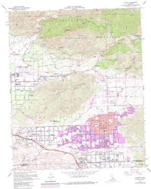
Yucaipa Topo Map California
To zoom in, hover over the map of Yucaipa
USGS Topo Quad 34117a1 - 1:24,000 scale
| Topo Map Name: | Yucaipa |
| USGS Topo Quad ID: | 34117a1 |
| Print Size: | ca. 21 1/4" wide x 27" high |
| Southeast Coordinates: | 34° N latitude / 117° W longitude |
| Map Center Coordinates: | 34.0625° N latitude / 117.0625° W longitude |
| U.S. State: | CA |
| Filename: | o34117a1.jpg |
| Download Map JPG Image: | Yucaipa topo map 1:24,000 scale |
| Map Type: | Topographic |
| Topo Series: | 7.5´ |
| Map Scale: | 1:24,000 |
| Source of Map Images: | United States Geological Survey (USGS) |
| Alternate Map Versions: |
Yucaipa CA 1954, updated 1955 Download PDF Buy paper map Yucaipa CA 1954, updated 1963 Download PDF Buy paper map Yucaipa CA 1967, updated 1968 Download PDF Buy paper map Yucaipa CA 1967, updated 1975 Download PDF Buy paper map Yucaipa CA 1967, updated 1980 Download PDF Buy paper map Yucaipa CA 1967, updated 1988 Download PDF Buy paper map Yucaipa CA 1996, updated 1999 Download PDF Buy paper map Yucaipa CA 2012 Download PDF Buy paper map Yucaipa CA 2015 Download PDF Buy paper map |
| FStopo: | US Forest Service topo Yucaipa is available: Download FStopo PDF Download FStopo TIF |
1:24,000 Topo Quads surrounding Yucaipa
> Back to 34117a1 at 1:100,000 scale
> Back to 34116a1 at 1:250,000 scale
> Back to U.S. Topo Maps home
Yucaipa topo map: Gazetteer
Yucaipa: Airports
Crafton Hills Airport (historical) elevation 690m 2263′Yucaipa: Canals
Bear Valley High Line Aqueduct elevation 654m 2145′Redlands Aqueduct elevation 550m 1804′
Yucaipa: Crossings
Interchange 83 elevation 623m 2043′Interchange 85 elevation 626m 2053′
Interchange 86 elevation 676m 2217′
Interchange 87 elevation 722m 2368′
Yucaipa: Dams
Yucaipa Number 1 2009 Dam elevation 789m 2588′Yucaipa Number 2 2009-002 Dam elevation 819m 2687′
Yucaipa Number 3 2009-003 Dam elevation 840m 2755′
Yucaipa: Parks
Thurman Flats Picnic Area elevation 1049m 3441′Yucaipa Regional Park elevation 807m 2647′
Yucaipa: Populated Places
Calimesa elevation 729m 2391′Crafton elevation 535m 1755′
Dunlap Acres elevation 646m 2119′
Greensport elevation 593m 1945′
Greenspot (historical) elevation 560m 1837′
North Bench elevation 939m 3080′
Yucaipa elevation 798m 2618′
Yucaipa: Post Offices
Yucaipa Post Office elevation 798m 2618′Yucaipa: Ranges
Crafton Hills elevation 1005m 3297′Yucaipa: Reservoirs
Crafton Reservoir elevation 593m 1945′Yucaipa: Ridges
Yucaipa Ridge elevation 1517m 4977′Yucaipa: Springs
Hot Springs elevation 689m 2260′Hot Springs elevation 710m 2329′
Yucaipa: Streams
Deep Creek elevation 585m 1919′Mill Creek elevation 514m 1686′
Mountain Home Creek elevation 1099m 3605′
Oak Glen Creek elevation 586m 1922′
Wilson Creek elevation 804m 2637′
Yucaipa: Summits
Cram Peak elevation 1269m 4163′Morton Peak elevation 1406m 4612′
Zanja Peak elevation 1077m 3533′
Yucaipa: Trails
Morton Ridge Trail elevation 1212m 3976′Santa Ana Divide Trail elevation 1064m 3490′
Yucaipa: Valleys
Government Canyon elevation 632m 2073′Green Canyon elevation 1022m 3353′
Mill Creek Canyon elevation 899m 2949′
Morton Canyon elevation 580m 1902′
Sand Canyon elevation 586m 1922′
Spoor Canyon elevation 1010m 3313′
Warm Springs Canyon elevation 691m 2267′
Water Canyon elevation 910m 2985′
Wildwood Canyon elevation 838m 2749′
Yucaipa Valley elevation 724m 2375′
Yucaipa digital topo map on disk
Buy this Yucaipa topo map showing relief, roads, GPS coordinates and other geographical features, as a high-resolution digital map file on DVD:


