San Dimas Topo Map California
To zoom in, hover over the map of San Dimas
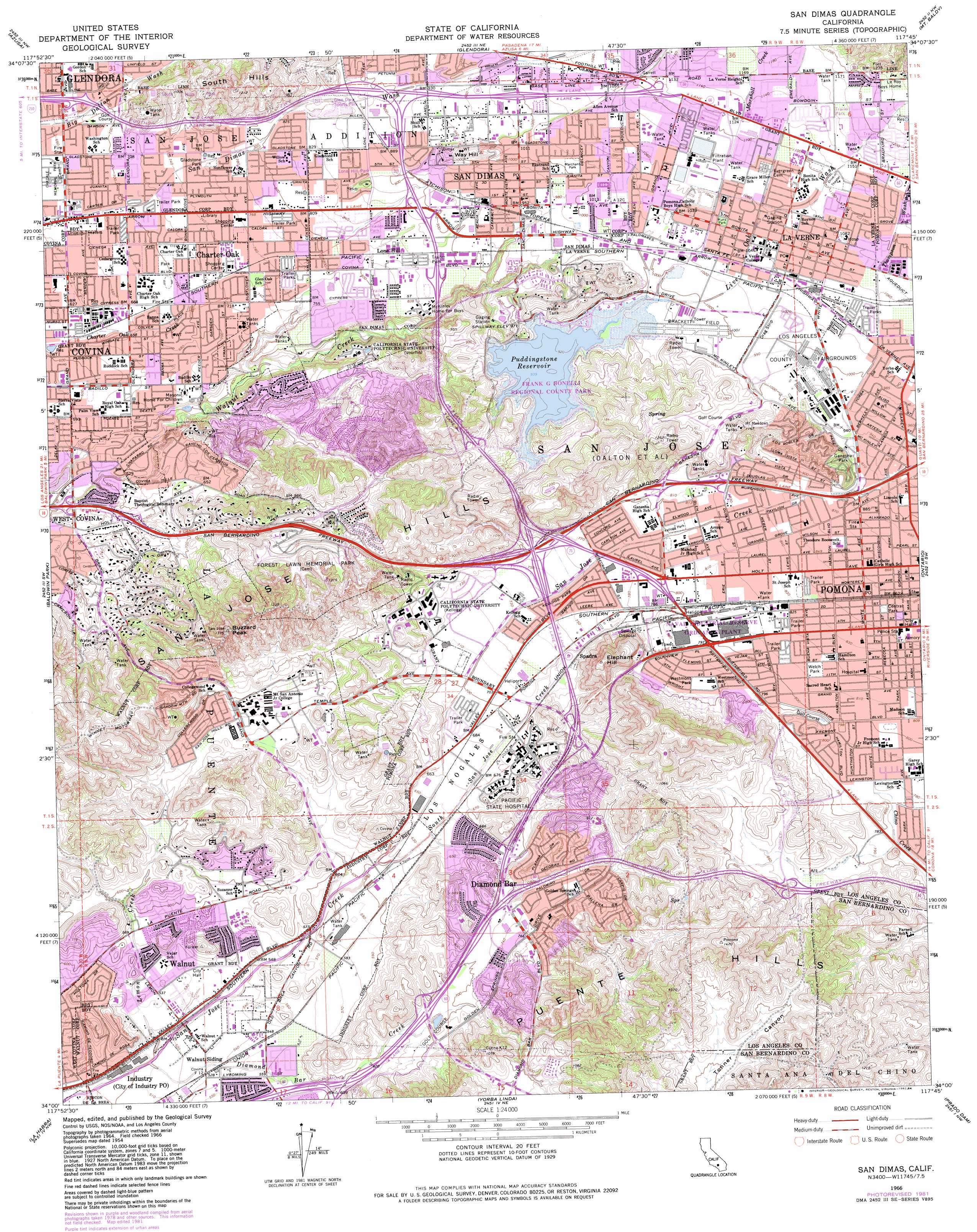
USGS Topo Quad 34117a7 - 1:24,000 scale
| Topo Map Name: | San Dimas |
| USGS Topo Quad ID: | 34117a7 |
| Print Size: | ca. 21 1/4" wide x 27" high |
| Southeast Coordinates: | 34° N latitude / 117.75° W longitude |
| Map Center Coordinates: | 34.0625° N latitude / 117.8125° W longitude |
| U.S. State: | CA |
| Filename: | o34117a7.jpg |
| Download Map JPG Image: | San Dimas topo map 1:24,000 scale |
| Map Type: | Topographic |
| Topo Series: | 7.5´ |
| Map Scale: | 1:24,000 |
| Source of Map Images: | United States Geological Survey (USGS) |
| Alternate Map Versions: |
San Dimas CA 1954, updated 1956 Download PDF Buy paper map San Dimas CA 1954, updated 1963 Download PDF Buy paper map San Dimas CA 1966, updated 1967 Download PDF Buy paper map San Dimas CA 1966, updated 1975 Download PDF Buy paper map San Dimas CA 1966, updated 1984 Download PDF Buy paper map San Dimas CA 2012 Download PDF Buy paper map San Dimas CA 2015 Download PDF Buy paper map |
1:24,000 Topo Quads surrounding San Dimas
Chilao Flat |
Waterman Mountain |
Crystal Lake |
Mount San Antonio |
Telegraph Peak |
Mount Wilson |
Azusa |
Glendora |
Mount Baldy |
Cucamonga Peak |
El Monte |
Baldwin Park |
San Dimas |
Ontario |
Guasti |
Whittier |
La Habra |
Yorba Linda |
Prado Dam |
Corona North |
Los Alamitos |
Anaheim |
Orange |
Black Star Canyon |
Corona South |
> Back to 34117a1 at 1:100,000 scale
> Back to 34116a1 at 1:250,000 scale
> Back to U.S. Topo Maps home
San Dimas topo map: Gazetteer
San Dimas: Airports
Brackett Field elevation 302m 990′Pomona Police Department Heliport elevation 335m 1099′
William Archibald Heliport elevation 299m 980′
San Dimas: Crossings
Exit 13 elevation 241m 790′Exit 14 elevation 243m 797′
Exit 15 elevation 235m 770′
Exit 18 elevation 242m 793′
Exit 20 elevation 251m 823′
Exit 21 elevation 228m 748′
Exit 22 elevation 313m 1026′
Exit 23 elevation 176m 577′
Exit 24A elevation 263m 862′
Exit 24A elevation 184m 603′
Exit 24B elevation 207m 679′
Exit 24B elevation 273m 895′
Exit 25 elevation 217m 711′
Exit 25A elevation 275m 902′
Exit 25B elevation 279m 915′
Exit 26 elevation 220m 721′
Exit 28 elevation 274m 898′
Exit 38A elevation 163m 534′
Exit 38B elevation 178m 583′
Exit 40 elevation 281m 921′
Exit 41 elevation 230m 754′
Exit 42 elevation 208m 682′
Exit 42A elevation 226m 741′
Exit 42B elevation 232m 761′
Exit 43 elevation 246m 807′
Exit 43 elevation 250m 820′
Exit 44 elevation 252m 826′
Exit 44 elevation 272m 892′
Exit 45A elevation 275m 902′
Exit 45B elevation 287m 941′
Exit 46 elevation 304m 997′
Exit 47 elevation 339m 1112′
Exit 48 elevation 356m 1167′
San Dimas: Dams
Live Oak Reservoir 35-013 Dam elevation 323m 1059′Puddingstone 32-009 Dam elevation 287m 941′
Weymouth Memorial Reservoir 35-011 Dam elevation 332m 1089′
San Dimas: Parks
Arroyo Park elevation 210m 688′Butterfield Park elevation 178m 583′
Carlton Peterson Park elevation 251m 823′
Central Park elevation 260m 853′
Charter Oak Park elevation 214m 702′
Civic Center Park elevation 296m 971′
Dawson Park elevation 212m 695′
Doctor Martin Luther King Junior Memorial Park elevation 239m 784′
East Shore Recreational Vehicle Park elevation 339m 1112′
Edison Historic District elevation 261m 856′
Emerald Park elevation 352m 1154′
Frank G Bonelli Regional County Park elevation 287m 941′
Ganesha Park elevation 302m 990′
Gladstone Park elevation 232m 761′
Glen Dora Sports Park elevation 254m 833′
Hamilton Park elevation 259m 849′
Happy Town Park elevation 226m 741′
Hilmer Lodge Stadium elevation 223m 731′
Kellogg Park elevation 245m 803′
Kellogg Park elevation 224m 734′
Kuns Park elevation 319m 1046′
La Verne Recreation Park elevation 314m 1030′
Ladera Serra Park elevation 299m 980′
Las Flores Park elevation 331m 1085′
Lemon Creek Bicentennial Park elevation 167m 547′
Lincoln Mini Park elevation 328m 1076′
Loma Vista Park elevation 248m 813′
Lone Hill Park elevation 257m 843′
Madison Park elevation 250m 820′
Marchant Park elevation 310m 1017′
Parque Xalapa elevation 183m 600′
Pelota Park elevation 327m 1072′
Phillips Ranch Park elevation 266m 872′
Pioneer Park elevation 282m 925′
Puddingstone Reservoir State Recreation Area elevation 296m 971′
Rancho Park elevation 212m 695′
Rhoads Park elevation 288m 944′
Snow Creek Park elevation 191m 626′
South Hills Park elevation 265m 869′
Spartan Stadium elevation 316m 1036′
Suzanne Park elevation 186m 610′
Sycamore Canyon Park elevation 224m 734′
Via Verde Park elevation 246m 807′
Walnut Creek Park elevation 190m 623′
Walnut Ranch Park elevation 232m 761′
Weber Street Park elevation 257m 843′
Welch Park elevation 249m 816′
Westmont Park elevation 241m 790′
Wilderness Park elevation 204m 669′
Wingate Park elevation 197m 646′
San Dimas: Populated Places
Charter Oak elevation 232m 761′Charter Oak Mobile Estates elevation 252m 826′
Diamond Bar elevation 212m 695′
La Verne elevation 323m 1059′
Lone Hill Manor Mobile Home Park elevation 240m 787′
North Pomona elevation 318m 1043′
Pomona elevation 259m 849′
Pomona Islander Mobile Home Park elevation 212m 695′
San Dimas elevation 291m 954′
Spadra elevation 227m 744′
Walnut elevation 171m 561′
Walnut Hills Mobile Home Park elevation 209m 685′
San Dimas: Post Offices
La Verne Post Office elevation 321m 1053′Pomona Post Office elevation 260m 853′
San Dimas Post Office elevation 296m 971′
Walnut Post Office elevation 160m 524′
Yorba Station Pomona Post Office elevation 309m 1013′
San Dimas: Ranges
San Jose Hills elevation 405m 1328′South Hills elevation 364m 1194′
San Dimas: Reservoirs
Puddingstone Reservoir elevation 287m 941′San Dimas: Streams
Diamond Bar Creek elevation 151m 495′Lemon Creek elevation 151m 495′
Live Oak Wash elevation 288m 944′
Marshall Creek elevation 341m 1118′
South San Jose Creek elevation 184m 603′
Thompson Wash elevation 285m 935′
San Dimas: Summits
Buzzard Peak elevation 402m 1318′Elephant Hill elevation 349m 1145′
Way Hill elevation 327m 1072′
San Dimas digital topo map on disk
Buy this San Dimas topo map showing relief, roads, GPS coordinates and other geographical features, as a high-resolution digital map file on DVD: