Glendora Topo Map California
To zoom in, hover over the map of Glendora
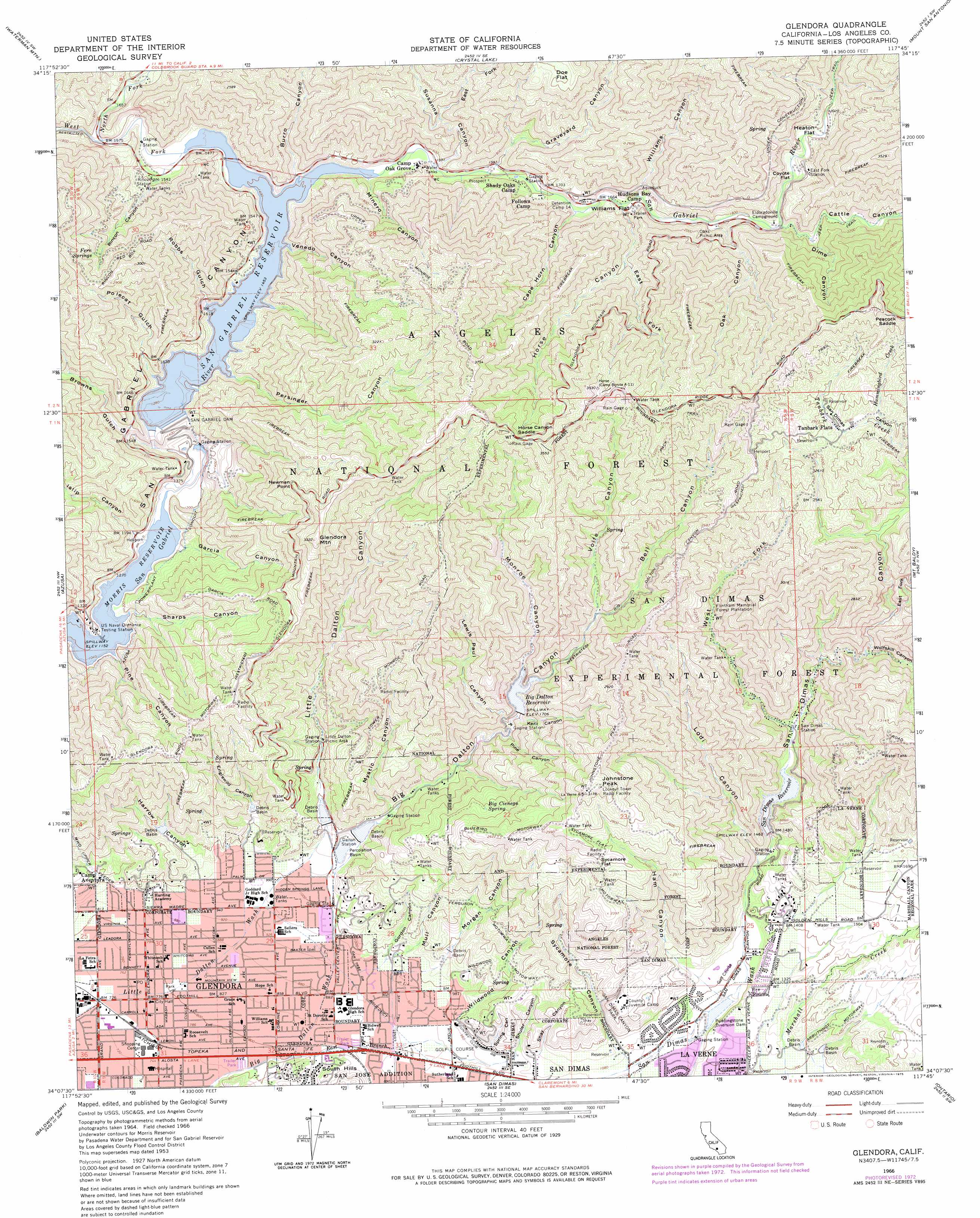
USGS Topo Quad 34117b7 - 1:24,000 scale
| Topo Map Name: | Glendora |
| USGS Topo Quad ID: | 34117b7 |
| Print Size: | ca. 21 1/4" wide x 27" high |
| Southeast Coordinates: | 34.125° N latitude / 117.75° W longitude |
| Map Center Coordinates: | 34.1875° N latitude / 117.8125° W longitude |
| U.S. State: | CA |
| Filename: | o34117b7.jpg |
| Download Map JPG Image: | Glendora topo map 1:24,000 scale |
| Map Type: | Topographic |
| Topo Series: | 7.5´ |
| Map Scale: | 1:24,000 |
| Source of Map Images: | United States Geological Survey (USGS) |
| Alternate Map Versions: |
Glendora CA 1953, updated 1955 Download PDF Buy paper map Glendora CA 1953, updated 1957 Download PDF Buy paper map Glendora CA 1953, updated 1964 Download PDF Buy paper map Glendora CA 1966, updated 1968 Download PDF Buy paper map Glendora CA 1966, updated 1975 Download PDF Buy paper map Glendora CA 1995, updated 1999 Download PDF Buy paper map Glendora CA 2012 Download PDF Buy paper map Glendora CA 2015 Download PDF Buy paper map |
1:24,000 Topo Quads surrounding Glendora
Pacifico Mountain |
Juniper Hills |
Valyermo |
Mescal Creek |
Phelan |
Chilao Flat |
Waterman Mountain |
Crystal Lake |
Mount San Antonio |
Telegraph Peak |
Mount Wilson |
Azusa |
Glendora |
Mount Baldy |
Cucamonga Peak |
El Monte |
Baldwin Park |
San Dimas |
Ontario |
Guasti |
Whittier |
La Habra |
Yorba Linda |
Prado Dam |
Corona North |
> Back to 34117a1 at 1:100,000 scale
> Back to 34116a1 at 1:250,000 scale
> Back to U.S. Topo Maps home
Glendora topo map: Gazetteer
Glendora: Airports
Foothill Presbyterian Hospital Heliport elevation 224m 734′Glendora: Capes
Newman Point elevation 930m 3051′Glendora: Dams
Big Dalton 32-000 Dam elevation 510m 1673′Big Dalton Debris Dam elevation 344m 1128′
Little Dalton Debris Dam elevation 352m 1154′
Puddingstone Diversion 32-016 Dam elevation 354m 1161′
Puddingstone Diversion Dam elevation 354m 1161′
San Dimas 32-010 Dam elevation 434m 1423′
San Gabriel Dam elevation 446m 1463′
Glendora: Flats
Berry Flat elevation 359m 1177′Coyote Flat elevation 577m 1893′
Doe Flat elevation 876m 2874′
Heaton Flat elevation 601m 1971′
Hoot Owl Flats elevation 536m 1758′
Sycamore Flat elevation 783m 2568′
Tanbark Flats elevation 814m 2670′
Williams Flat elevation 508m 1666′
Glendora: Forests
San Dimas Experimental Forest elevation 751m 2463′Glendora: Gaps
Horse Canyon Saddle elevation 1009m 3310′Peacock Saddle elevation 1041m 3415′
Glendora: Mines
Davis Mine elevation 473m 1551′Glendora: Parks
Finkbiner Park elevation 246m 807′George Manooshian Park elevation 301m 987′
Heritage Park elevation 383m 1256′
Los Encinos Park elevation 357m 1171′
Lowell Brandt Park elevation 448m 1469′
Mills Park elevation 394m 1292′
Ole Hammer Park elevation 264m 866′
San Dimas Canyon Nature Center elevation 332m 1089′
San Dimas Canyon Park elevation 412m 1351′
Willow Springs Park elevation 290m 951′
Glendora: Populated Places
Glendora elevation 236m 774′Glendora: Post Offices
Glendora Post Office elevation 234m 767′Glendora: Reservoirs
Big Dalton Reservoir elevation 510m 1673′San Dimas Reservoir elevation 434m 1423′
San Gabriel Reservoir elevation 446m 1463′
Glendora: Springs
Big Cienega Spring elevation 635m 2083′Fern Springs elevation 734m 2408′
Glendora: Streams
East Branch Big Dalton Wash elevation 244m 800′Hummingbird Creek elevation 780m 2559′
North Fork San Gabriel River elevation 473m 1551′
Tanbark Creek elevation 676m 2217′
West Fork San Gabriel River elevation 449m 1473′
Glendora: Summits
Glendora Mountain elevation 1016m 3333′Johnstone Peak elevation 966m 3169′
Glendora: Valleys
Bell Canyon elevation 581m 1906′Big Dalton Canyon elevation 330m 1082′
Browns Gulch elevation 390m 1279′
Burro Canyon elevation 447m 1466′
Cape Horn Canyon elevation 496m 1627′
Cattle Canyon elevation 568m 1863′
Dime Canyon elevation 590m 1935′
East Fork Horse Canyon elevation 606m 1988′
East Fork San Dimas Canyon elevation 562m 1843′
East Fork Susanna Canyon elevation 522m 1712′
Englewild Canyon elevation 345m 1131′
Garcia Canyon elevation 368m 1207′
Gordon Canyon elevation 301m 987′
Graveyard Canyon elevation 486m 1594′
Ham Canyon elevation 386m 1266′
Harrow Canyon elevation 341m 1118′
Horse Canyon elevation 530m 1738′
Islip Canyon elevation 367m 1204′
Keril Canyon elevation 502m 1646′
Lewis Paul Canyon elevation 489m 1604′
Little Dalton Canyon elevation 346m 1135′
Lodi Canyon elevation 410m 1345′
Minero Canyon elevation 462m 1515′
Monroe Canyon elevation 511m 1676′
Morgan Canyon elevation 347m 1138′
Mull Canyon elevation 304m 997′
Mystic Canyon elevation 380m 1246′
Oak Canyon elevation 549m 1801′
Peacock Canyon elevation 667m 2188′
Persinger Canyon elevation 444m 1456′
Pine Canyon elevation 352m 1154′
Pine Canyon elevation 467m 1532′
Polecat Gulch elevation 444m 1456′
Rincon Canyon elevation 473m 1551′
Robbs Gulch elevation 444m 1456′
San Dimas Canyon elevation 676m 2217′
Sharps Canyon elevation 352m 1154′
Shay Canyon elevation 339m 1112′
Shuler Canyon elevation 314m 1030′
Spring Canyon elevation 306m 1003′
Susanna Canyon elevation 471m 1545′
Sycamore Canyon elevation 346m 1135′
Venedo Canyon elevation 444m 1456′
Volfe Canyon elevation 581m 1906′
West Fork San Dimas Canyon elevation 456m 1496′
Wildwood Canyon elevation 302m 990′
Williams Canyon elevation 568m 1863′
Wolfskill Canyon elevation 527m 1729′
Glendora digital topo map on disk
Buy this Glendora topo map showing relief, roads, GPS coordinates and other geographical features, as a high-resolution digital map file on DVD: