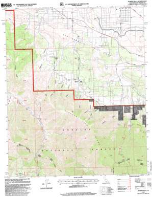
Juniper Hills Topo Map California
To zoom in, hover over the map of Juniper Hills
USGS Topo Quad 34117d8 - 1:24,000 scale
| Topo Map Name: | Juniper Hills |
| USGS Topo Quad ID: | 34117d8 |
| Print Size: | ca. 21 1/4" wide x 27" high |
| Southeast Coordinates: | 34.375° N latitude / 117.875° W longitude |
| Map Center Coordinates: | 34.4375° N latitude / 117.9375° W longitude |
| U.S. State: | CA |
| Filename: | o34117d8.jpg |
| Download Map JPG Image: | Juniper Hills topo map 1:24,000 scale |
| Map Type: | Topographic |
| Topo Series: | 7.5´ |
| Map Scale: | 1:24,000 |
| Source of Map Images: | United States Geological Survey (USGS) |
| Alternate Map Versions: |
Juniper Hills CA 1959, updated 1960 Download PDF Buy paper map Juniper Hills CA 1959, updated 1965 Download PDF Buy paper map Juniper Hills CA 1959, updated 1975 Download PDF Buy paper map Juniper Hills CA 1959, updated 1988 Download PDF Buy paper map Juniper Hills CA 1995, updated 1999 Download PDF Buy paper map Juniper Hills CA 2012 Download PDF Buy paper map Juniper Hills CA 2015 Download PDF Buy paper map |
1:24,000 Topo Quads surrounding Juniper Hills
> Back to 34117a1 at 1:100,000 scale
> Back to 34116a1 at 1:250,000 scale
> Back to U.S. Topo Maps home
Juniper Hills topo map: Gazetteer
Juniper Hills: Basins
Juniper Bowl elevation 1193m 3914′Juniper Hills: Canals
Fort Tejon Siphon elevation 1047m 3435′Juniper Hills: Flats
Pinyon Flats elevation 1625m 5331′Juniper Hills: Gaps
Burkhart Saddle elevation 2118m 6948′Juniper Hills: Parks
Juniper Hills Park elevation 1211m 3973′Juniper Hills: Populated Places
Juniper Hills elevation 1324m 4343′Longview elevation 982m 3221′
Juniper Hills: Ridges
Alimony Ridge elevation 1506m 4940′Pleasant View Ridge elevation 2419m 7936′
Winston Ridge elevation 2017m 6617′
Juniper Hills: Springs
Moss Spring elevation 2190m 7185′Juniper Hills: Streams
Cruthers Creek elevation 1210m 3969′Holmes Creek elevation 1171m 3841′
South Fork Little Rock Creek elevation 1217m 3992′
Watkins Creek elevation 1231m 4038′
Juniper Hills: Summits
Bare Mountain elevation 1937m 6354′Clima Mesa elevation 1215m 3986′
Pallett Mountain elevation 2359m 7739′
Will Thrall Peak elevation 2387m 7831′
Juniper Hills: Trails
Burkhart Trail elevation 1940m 6364′Juniper Hills: Valleys
Bare Mountain Canyon elevation 1098m 3602′Brainard Canyon elevation 1068m 3503′
Hutak Canyon elevation 1211m 3973′
Indian Bill Canyon elevation 1184m 3884′
John Bird Canyon elevation 1184m 3884′
Matay Canyon elevation 1211m 3973′
McClure Canyon elevation 1220m 4002′
Miller Canyon elevation 1218m 3996′
Pechner Canyon elevation 1319m 4327′
Squaw Canyon elevation 1413m 4635′
Juniper Hills digital topo map on disk
Buy this Juniper Hills topo map showing relief, roads, GPS coordinates and other geographical features, as a high-resolution digital map file on DVD:


