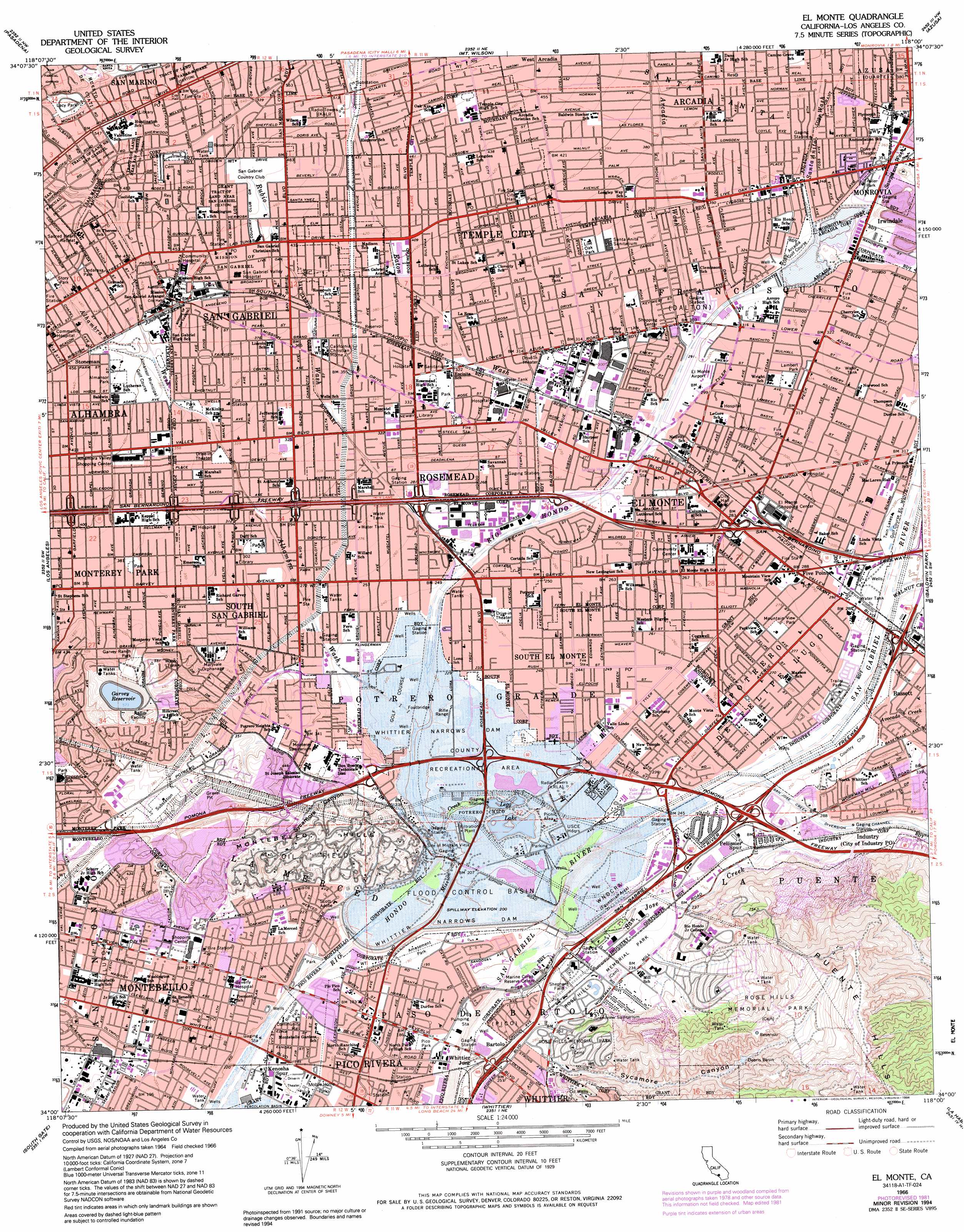
El Monte Topo Map California
To zoom in, hover over the map of El Monte
USGS Topo Quad 34118a1 - 1:24,000 scale
| Topo Map Name: | El Monte |
| USGS Topo Quad ID: | 34118a1 |
| Print Size: | ca. 21 1/4" wide x 27" high |
| Southeast Coordinates: | 34° N latitude / 118° W longitude |
| Map Center Coordinates: | 34.0625° N latitude / 118.0625° W longitude |
| U.S. State: | CA |
| Filename: | o34118a1.jpg |
| Download Map JPG Image: | El Monte topo map 1:24,000 scale |
| Map Type: | Topographic |
| Topo Series: | 7.5´ |
| Map Scale: | 1:24,000 |
| Source of Map Images: | United States Geological Survey (USGS) |
| Alternate Map Versions: |
El Monte CA 1953, updated 1955 Download PDF Buy paper map El Monte CA 1953, updated 1963 Download PDF Buy paper map El Monte CA 1966, updated 1968 Download PDF Buy paper map El Monte CA 1966, updated 1968 Download PDF Buy paper map El Monte CA 1966, updated 1975 Download PDF Buy paper map El Monte CA 1966, updated 1982 Download PDF Buy paper map El Monte CA 1966, updated 1985 Download PDF Buy paper map El Monte CA 1966, updated 1994 Download PDF Buy paper map El Monte CA 1966, updated 1994 Download PDF Buy paper map El Monte CA 2012 Download PDF Buy paper map El Monte CA 2015 Download PDF Buy paper map |
1:24,000 Topo Quads surrounding El Monte
Sunland |
Condor Peak |
Chilao Flat |
Waterman Mountain |
Crystal Lake |
Burbank |
Pasadena |
Mount Wilson |
Azusa |
Glendora |
Hollywood |
Los Angeles |
El Monte |
Baldwin Park |
San Dimas |
Inglewood |
South Gate |
Whittier |
La Habra |
Yorba Linda |
Torrance |
Long Beach |
Los Alamitos |
Anaheim |
Orange |
> Back to 34118a1 at 1:100,000 scale
> Back to 34118a1 at 1:250,000 scale
> Back to U.S. Topo Maps home
El Monte topo map: Gazetteer
El Monte: Airports
Alhambra Airport (historical) elevation 120m 393′El Monte Airport elevation 85m 278′
Rosemead Airport (historical) elevation 79m 259′
SCE Headquarters Heliport elevation 70m 229′
SCE Rosemead Heliport elevation 71m 232′
Shepherd Field (historical) elevation 63m 206′
Wells Fargo-El Monte Heliport elevation 83m 272′
El Monte: Canals
San Jose Creek Diversion Channel elevation 76m 249′El Monte: Crossings
Exit 10A elevation 68m 223′Exit 10B elevation 68m 223′
Exit 11 elevation 74m 242′
Exit 12 elevation 80m 262′
Exit 13 elevation 91m 298′
Exit 16 elevation 67m 219′
Exit 17 elevation 67m 219′
Exit 18 elevation 72m 236′
Exit 19 elevation 79m 259′
Exit 21 elevation 92m 301′
Exit 23B elevation 123m 403′
Exit 24 elevation 110m 360′
Exit 25A elevation 95m 311′
Exit 25B elevation 92m 301′
Exit 26A elevation 87m 285′
Exit 26B elevation 86m 282′
Exit 27 elevation 81m 265′
Exit 28 elevation 86m 282′
Exit 29A elevation 86m 282′
Exit 29B elevation 92m 301′
Exit 29C elevation 92m 301′
Exit 31A elevation 92m 301′
Exit 6 elevation 96m 314′
Exit 8 elevation 105m 344′
Exit 9 elevation 83m 272′
El Monte: Dams
Garvey 35-006 Dam elevation 175m 574′Whittier Narrows Dam elevation 59m 193′
El Monte: Gaps
Whittier Narrows elevation 64m 209′El Monte: Lakes
Legg Lake elevation 60m 196′El Monte: Parks
Acuna Park elevation 87m 285′Almansor Park elevation 127m 416′
Arceo Park elevation 84m 275′
Baldwin Stocker Park elevation 129m 423′
Bicentennial Park elevation 111m 364′
Camino Grove Park elevation 123m 403′
Community Center Park elevation 96m 314′
Fletcher Park elevation 81m 265′
Garvey Park elevation 90m 295′
Garvey Ranch Park elevation 128m 419′
Grant Rea Park elevation 56m 183′
Jess Gonzales Sports Park elevation 74m 242′
Joslyn Adult Recreation Center elevation 145m 475′
Klingerman Park elevation 70m 229′
La Loma Park elevation 125m 410′
Lacy Park elevation 169m 554′
Lambert Park elevation 96m 314′
Lindaraka Park elevation 145m 475′
Live Oak Park elevation 111m 364′
Longden Avenue Park elevation 111m 364′
Mary Van Dyke Park elevation 75m 246′
Montebello Park elevation 62m 203′
Mountain View Park elevation 84m 275′
New Temple Park elevation 72m 236′
Peck Road Park elevation 103m 337′
Pico Park elevation 58m 190′
Pico Rivera Bicentennial Park elevation 67m 219′
Pioneer Park elevation 82m 269′
Potrero Heights Park elevation 100m 328′
Reggie Rodriguez Park elevation 65m 213′
Rio Hondo Park elevation 55m 180′
Rod Marinelli Stadium elevation 102m 334′
Rosemead Park elevation 99m 324′
Sally Tanner Park elevation 112m 367′
San Angelo Park elevation 89m 291′
Santa Anita Park elevation 116m 380′
Shepherd Field elevation 63m 206′
Shiveley Park elevation 71m 232′
Sierra Vista Park elevation 117m 383′
Smith Park elevation 129m 423′
Story Park elevation 148m 485′
Streamland Park elevation 59m 193′
Temple City Park elevation 122m 400′
Tierra Verde Park elevation 121m 396′
Vincent Lugo Park elevation 108m 354′
Whittier Narrows Dam County Recreational Are elevation 68m 223′
Whittier Narrows Nature Center elevation 70m 229′
Zamora Park elevation 94m 308′
Zapopan Park elevation 83m 272′
El Monte: Populated Places
Bartolo elevation 62m 203′Bartolo (historical) elevation 68m 223′
Clayton (historical) elevation 72m 236′
East Arcadia elevation 101m 331′
East San Gabriel elevation 115m 377′
El Monte elevation 91m 298′
Five Points elevation 88m 288′
Hayes elevation 90m 295′
Maxson elevation 96m 314′
Mayflower Village elevation 112m 367′
Montebello elevation 61m 200′
Monterey Park elevation 117m 383′
North El Monte elevation 101m 331′
Ramona Park elevation 123m 403′
Rosemead elevation 97m 318′
San Gabriel elevation 128m 419′
San Marino elevation 172m 564′
Savannah (historical) elevation 84m 275′
Sibagna (historical) elevation 131m 429′
South El Monte elevation 76m 249′
South San Gabriel elevation 83m 272′
Stoneman elevation 138m 452′
Temple City elevation 122m 400′
Whittier Junction elevation 67m 219′
Wilmar elevation 110m 360′
El Monte: Post Offices
El Monte Post Office elevation 87m 285′Montebello Post Office elevation 62m 203′
Rosemead Post Office elevation 99m 324′
San Gabriel Post Office elevation 134m 439′
San Marino Post Office (historical) elevation 170m 557′
South El Monte Post Office elevation 77m 252′
South San Gabriel Station Rosemead Post Office elevation 83m 272′
Temple City Post Office elevation 127m 416′
El Monte: Reservoirs
Garvey Reservoir elevation 178m 583′Whittier Narrows Reservoir elevation 59m 193′
El Monte: Streams
Alhambra Wash elevation 61m 200′Arcadia Wash elevation 84m 275′
Avocado Creek elevation 80m 262′
Eaton Wash elevation 74m 242′
Mission Creek elevation 61m 200′
Rubio Wash elevation 66m 216′
San Jose Creek elevation 59m 193′
Santa Anita Wash elevation 98m 321′
Sawpit Wash elevation 100m 328′
Walnut Creek elevation 84m 275′
El Monte: Summits
Montebello Hills elevation 172m 564′El Monte: Valleys
San Gabriel Valley elevation 69m 226′Sycamore Canyon elevation 93m 305′
Sycamore Canyon elevation 71m 232′
El Monte digital topo map on disk
Buy this El Monte topo map showing relief, roads, GPS coordinates and other geographical features, as a high-resolution digital map file on DVD: