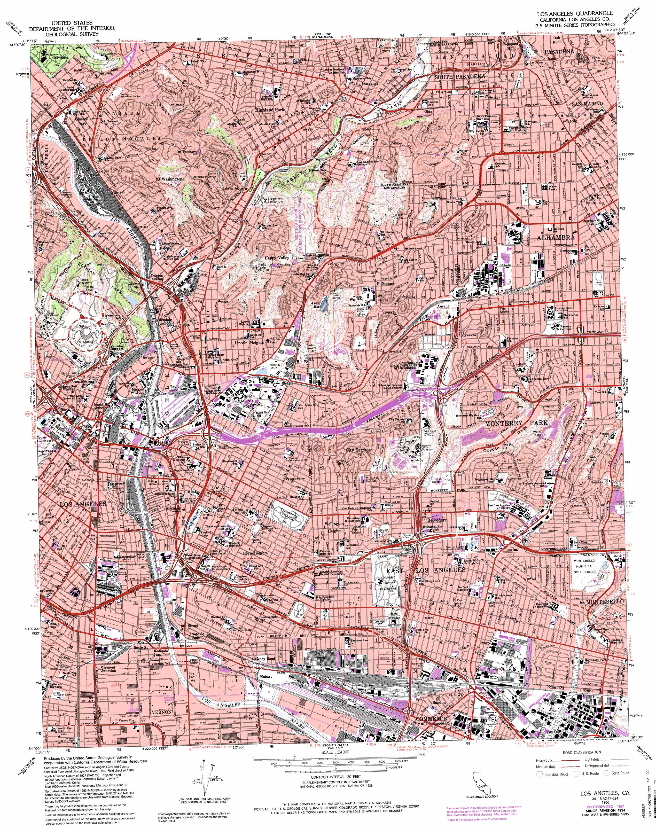
Los Angeles Topo Map California
To zoom in, hover over the map of Los Angeles
USGS Topo Quad 34118a2 - 1:24,000 scale
| Topo Map Name: | Los Angeles |
| USGS Topo Quad ID: | 34118a2 |
| Print Size: | ca. 21 1/4" wide x 27" high |
| Southeast Coordinates: | 34° N latitude / 118.125° W longitude |
| Map Center Coordinates: | 34.0625° N latitude / 118.1875° W longitude |
| U.S. State: | CA |
| Filename: | o34118a2.jpg |
| Download Map JPG Image: | Los Angeles topo map 1:24,000 scale |
| Map Type: | Topographic |
| Topo Series: | 7.5´ |
| Map Scale: | 1:24,000 |
| Source of Map Images: | United States Geological Survey (USGS) |
| Alternate Map Versions: |
Los Angeles CA 1953, updated 1956 Download PDF Buy paper map Los Angeles CA 1966, updated 1968 Download PDF Buy paper map Los Angeles CA 1966, updated 1975 Download PDF Buy paper map Los Angeles CA 1966, updated 1982 Download PDF Buy paper map Los Angeles CA 1966, updated 1987 Download PDF Buy paper map Los Angeles CA 1966, updated 1994 Download PDF Buy paper map Los Angeles CA 2012 Download PDF Buy paper map Los Angeles CA 2015 Download PDF Buy paper map |
1:24,000 Topo Quads surrounding Los Angeles
San Fernando |
Sunland |
Condor Peak |
Chilao Flat |
Waterman Mountain |
Van Nuys |
Burbank |
Pasadena |
Mount Wilson |
Azusa |
Beverly Hills |
Hollywood |
Los Angeles |
El Monte |
Baldwin Park |
Venice |
Inglewood |
South Gate |
Whittier |
La Habra |
Redondo Beach |
Torrance |
Long Beach |
Los Alamitos |
Anaheim |
> Back to 34118a1 at 1:100,000 scale
> Back to 34118a1 at 1:250,000 scale
> Back to U.S. Topo Maps home
Los Angeles topo map: Gazetteer
Los Angeles: Airports
California Title Building Heliport elevation 231m 757′City Hall Heliport elevation 95m 311′
District 07 Helistop elevation 89m 291′
Hotel New Otani Los Angeles Heliport elevation 86m 282′
Jay Stephen Hooper Memorial Heliport elevation 86m 282′
LAPD Central Facilities Heliport elevation 77m 252′
Los Angeles County Mens Detention Center - Main Jail Heliport elevation 89m 291′
Los Angeles County Sheriffs Department Heliport elevation 82m 269′
Los Angeles Times-Los Angeles Heliport elevation 86m 282′
Parker Center Heliport elevation 86m 282′
Santa Fe International Corp Heliport elevation 141m 462′
SCE Energy Control Center Heliport elevation 145m 475′
SFI-Vernon Heliport elevation 59m 193′
Sheriffs Headquarters - Temple and Grand Heliport elevation 119m 390′
Telegraph Atlantic Airport (historical) elevation 49m 160′
Terminal Annex Heliport elevation 86m 282′
Transamerica Center Heliport elevation 75m 246′
USC University Hospital Heliport elevation 111m 364′
Vail Field (historical) elevation 52m 170′
Los Angeles: Areas
Paseo De Los Pobladores elevation 106m 347′Los Angeles: Basins
Los Angeles Basin elevation 84m 275′Los Angeles: Crossings
Exit 129 elevation 46m 150′Exit 130A elevation 47m 154′
Exit 130B elevation 52m 170′
Exit 130C elevation 51m 167′
Exit 131A elevation 58m 190′
Exit 131B elevation 62m 203′
Exit 132 elevation 61m 200′
Exit 133 elevation 73m 239′
Exit 134A elevation 86m 282′
Exit 135A elevation 87m 285′
Exit 135B elevation 103m 337′
Exit 135C elevation 97m 318′
Exit 136A elevation 97m 318′
Exit 136B elevation 97m 318′
Exit 137A elevation 104m 341′
Exit 137B elevation 131m 429′
Exit 138 elevation 112m 367′
Exit 139A elevation 118m 387′
Exit 15A elevation 71m 232′
Exit 15B elevation 71m 232′
Exit 17 elevation 93m 305′
Exit 17C elevation 49m 160′
Exit 18A elevation 50m 164′
Exit 18B elevation 55m 180′
Exit 19 elevation 62m 203′
Exit 1A elevation 84m 275′
Exit 1B elevation 88m 288′
Exit 1B elevation 92m 301′
Exit 1C elevation 95m 311′
Exit 1D elevation 90m 295′
Exit 1D elevation 92m 301′
Exit 1E elevation 83m 272′
Exit 2 elevation 91m 298′
Exit 20A elevation 127m 416′
Exit 20A elevation 86m 282′
Exit 20B elevation 125m 410′
Exit 20B elevation 86m 282′
Exit 20C elevation 92m 301′
Exit 21 elevation 135m 442′
Exit 21 elevation 101m 331′
Exit 22 elevation 129m 423′
Exit 22 elevation 116m 380′
Exit 23A elevation 126m 413′
Exit 24A elevation 104m 341′
Exit 24B elevation 102m 334′
Exit 24C elevation 110m 360′
Exit 24D elevation 141m 462′
Exit 25 elevation 130m 426′
Exit 26A elevation 101m 331′
Exit 26B elevation 105m 344′
Exit 27 elevation 122m 400′
Exit 28A elevation 141m 462′
Exit 28B elevation 142m 465′
Exit 29 elevation 154m 505′
Exit 2A elevation 84m 275′
Exit 2B elevation 86m 282′
Exit 2C elevation 97m 318′
Exit 30A elevation 161m 528′
Exit 30B elevation 173m 567′
Exit 31A elevation 202m 662′
Exit 31B elevation 212m 695′
Exit 3A elevation 83m 272′
Exit 3A elevation 114m 374′
Exit 3B elevation 110m 360′
Exit 3B elevation 92m 301′
Exit 4 elevation 77m 252′
Los Angeles: Dams
Ascot 6-000 Dam elevation 191m 626′Elysian 6-006 Dam elevation 141m 462′
Highland 6-012 Dam elevation 190m 623′
Laguna Regulating Basin 32-022 Dam elevation 109m 357′
Los Angeles: Gaps
Coyote Pass elevation 124m 406′Los Angeles: Parks
Alhambra Park elevation 160m 524′Alpine Park elevation 98m 321′
Arroyo Seco Park elevation 198m 649′
Ashiya Park elevation 71m 232′
Atlantic Avenue Park elevation 65m 213′
Bandini Park elevation 49m 160′
Barnes Memorial Park elevation 115m 377′
Bella Vista Park elevation 87m 285′
Belvedere Park elevation 86m 282′
Bicknell Park elevation 95m 311′
Boyle Heights Recreation Center elevation 80m 262′
Boyle Heights Sports Center Park elevation 79m 259′
Bristow Park elevation 50m 164′
Burke Park elevation 163m 534′
Carlin Smith Playground elevation 194m 636′
Cascades Park elevation 116m 380′
City Terrace Park elevation 139m 456′
Cleland Avenue Bicentennial Park elevation 193m 633′
Costello Recreation Center elevation 68m 223′
Cypress Park elevation 105m 344′
Dodger Stadium elevation 159m 521′
Downey Playground elevation 92m 301′
Downey Recreation Center elevation 92m 301′
Eddie Park elevation 179m 587′
Edison Trails Park elevation 107m 351′
El Sereno North Park elevation 172m 564′
El Sereno Recreation Center elevation 134m 439′
Ela Park elevation 129m 423′
Elysian Park elevation 181m 593′
Elysian Valley Recreation Center elevation 108m 354′
Ernest E. Debs Regional Park elevation 202m 662′
Everett Park elevation 160m 524′
Evergreen Playground elevation 88m 288′
Evergreen Recreation Center elevation 88m 288′
Fort Moore Pioneer Memorial elevation 111m 364′
Garfield Park elevation 196m 643′
Garvanza Park elevation 191m 626′
George E Elder Park elevation 99m 324′
Glassell Park elevation 141m 462′
Granada Park elevation 146m 479′
Grandview Park elevation 97m 318′
Greaver Oak Park elevation 121m 396′
Hazard Park elevation 112m 367′
Henry Alvarez Memorial Park elevation 112m 367′
Heritage Square elevation 109m 357′
Highland Park elevation 177m 580′
Highland Park Recreation Center elevation 175m 574′
Highlands Park elevation 148m 485′
Hollenbeck Park elevation 86m 282′
Hostetter Playground elevation 68m 223′
Jesse Owens Track And Field elevation 143m 469′
Langley Park elevation 120m 393′
Lincoln Heights Recreation Center elevation 102m 334′
Lincoln Park elevation 108m 354′
Lincoln Park Recreation Center elevation 109m 357′
Little Tokyo Historic District elevation 84m 275′
Little Toyoko Historic District elevation 83m 272′
Los Angeles Plaza Historic District elevation 92m 301′
Los Angeles State Historic Park elevation 91m 298′
Lummis Park elevation 122m 400′
Montecito Heights Recreation Center elevation 132m 433′
Montecito Park elevation 190m 623′
Moor Field elevation 133m 436′
Obregon Park elevation 78m 255′
Pecan Playground elevation 80m 262′
Pecan Recreation Center elevation 82m 269′
Pinetree Park elevation 185m 606′
Poplar Recreation Center elevation 105m 344′
Prospect Park elevation 107m 351′
Ramon Garcia Recreation Center elevation 79m 259′
Ramona Gardens Park elevation 108m 354′
Reeder Field elevation 143m 469′
Rio de Los Angeles State Park elevation 111m 364′
Roberts Recreation Center elevation 59m 193′
Rose Hill Park elevation 193m 633′
Rose Hill Playground elevation 144m 472′
Rose Hill Recreation Center elevation 143m 469′
Rosewood Park elevation 44m 144′
Ross Snyder Recreation Center elevation 63m 206′
Salazar Park elevation 67m 219′
Saybrook Park elevation 57m 187′
Sequoia Park elevation 197m 646′
Smith Recreation Center elevation 204m 669′
South Pasadena Historic District elevation 205m 672′
State Street Playground elevation 107m 351′
State Street Recreation Center elevation 105m 344′
Sunnyslopes Park elevation 129m 423′
Sycamore Grove Park elevation 131m 429′
Verdugo Recreation Center elevation 126m 413′
Wabash Playground elevation 118m 387′
Wabash Recreation Center elevation 118m 387′
Weingart Stadium elevation 91m 298′
Woods Avenue Park elevation 57m 187′
Los Angeles: Populated Places
Alhambra elevation 150m 492′Aliso Village elevation 81m 265′
Aurant elevation 132m 433′
Baird Park elevation 162m 531′
Bandini elevation 47m 154′
Belvedere elevation 93m 305′
Belvedere Gardens elevation 70m 229′
Boston Heights elevation 118m 387′
Boyle Heights elevation 103m 337′
Brooklyn Heights elevation 102m 334′
Butte Street Junction elevation 67m 219′
City Terrace elevation 167m 547′
Clement Junction elevation 66m 216′
Commerce elevation 43m 141′
Cypress Park elevation 110m 360′
Dayton Avenue elevation 107m 351′
East Los Angeles elevation 61m 200′
Eastmont elevation 63m 206′
El Sereno elevation 138m 452′
Garvanza elevation 185m 606′
Glassell Park elevation 123m 403′
Glendale Junction elevation 93m 305′
Happy Valley elevation 156m 511′
Highland Park elevation 171m 561′
Hobart elevation 59m 193′
Lincoln Heights elevation 110m 360′
Little Tokyo elevation 82m 269′
Los Angeles elevation 89m 291′
Maravilla elevation 91m 298′
Maravilla Housing Project elevation 91m 298′
Mission Junction elevation 87m 285′
Mount Washington elevation 235m 770′
Naud Junction elevation 89m 291′
Nevin elevation 66m 216′
New Chinatown elevation 95m 311′
Newton Park elevation 179m 587′
Ninth Street Junction elevation 73m 239′
North Highland Park elevation 187m 613′
Oak Knoll elevation 224m 734′
Old Chinatown (historical) elevation 86m 282′
Olga elevation 195m 639′
Omaha Heights elevation 182m 597′
Pico Gardens elevation 77m 252′
Ramona Gardens elevation 114m 374′
Raymond Hill elevation 254m 833′
Redondo Junction elevation 68m 223′
Rose Hill elevation 237m 777′
Shorb elevation 137m 449′
Sierra Vista elevation 159m 521′
Soto Street Junction elevation 71m 232′
South Pasadena elevation 201m 659′
Taylor Junction elevation 89m 291′
Vernon elevation 62m 203′
Wellington Heights elevation 98m 321′
Winter Gardens elevation 53m 173′
Wyvernwood elevation 72m 236′
Los Angeles: Post Offices
Boyle Heights Station Los Angeles Post Office elevation 91m 298′City of Commerce Post Office elevation 43m 141′
Commerce Station Los Angeles Post Office elevation 43m 141′
East Los Angeles Branch Los Angeles Post Office elevation 56m 183′
El Sereno Station Los Angeles Post Office elevation 140m 459′
Glassell Station Los Angeles Post Office elevation 134m 439′
Hazard Branch Los Angeles Post Office elevation 99m 324′
Highland Park Station Los Angeles Post Office elevation 168m 551′
Lincoln Heights Station Los Angeles Post Office elevation 107m 351′
Los Angeles Main Post Office elevation 88m 288′
Lugo Station Los Angeles Post Office elevation 60m 196′
Market Station Los Angeles Post Office elevation 77m 252′
Post Office Terminal elevation 88m 288′
South Pasadena Post Office elevation 200m 656′
York Station Los Angeles Post Office elevation 171m 561′
Los Angeles: Reservoirs
Ascot Reservoir elevation 191m 626′Garfield Reservoirs elevation 162m 531′
Garvanza Reservoir elevation 226m 741′
Hazard Reservoir elevation 138m 452′
Highland Reservoir elevation 190m 623′
Los Angeles: Streams
Arroyo Seco elevation 92m 301′Luguna Channel elevation 90m 295′
Los Angeles: Valleys
Chavez Ravine elevation 107m 351′Los Angeles digital topo map on disk
Buy this Los Angeles topo map showing relief, roads, GPS coordinates and other geographical features, as a high-resolution digital map file on DVD: