Hollywood Topo Map California
To zoom in, hover over the map of Hollywood
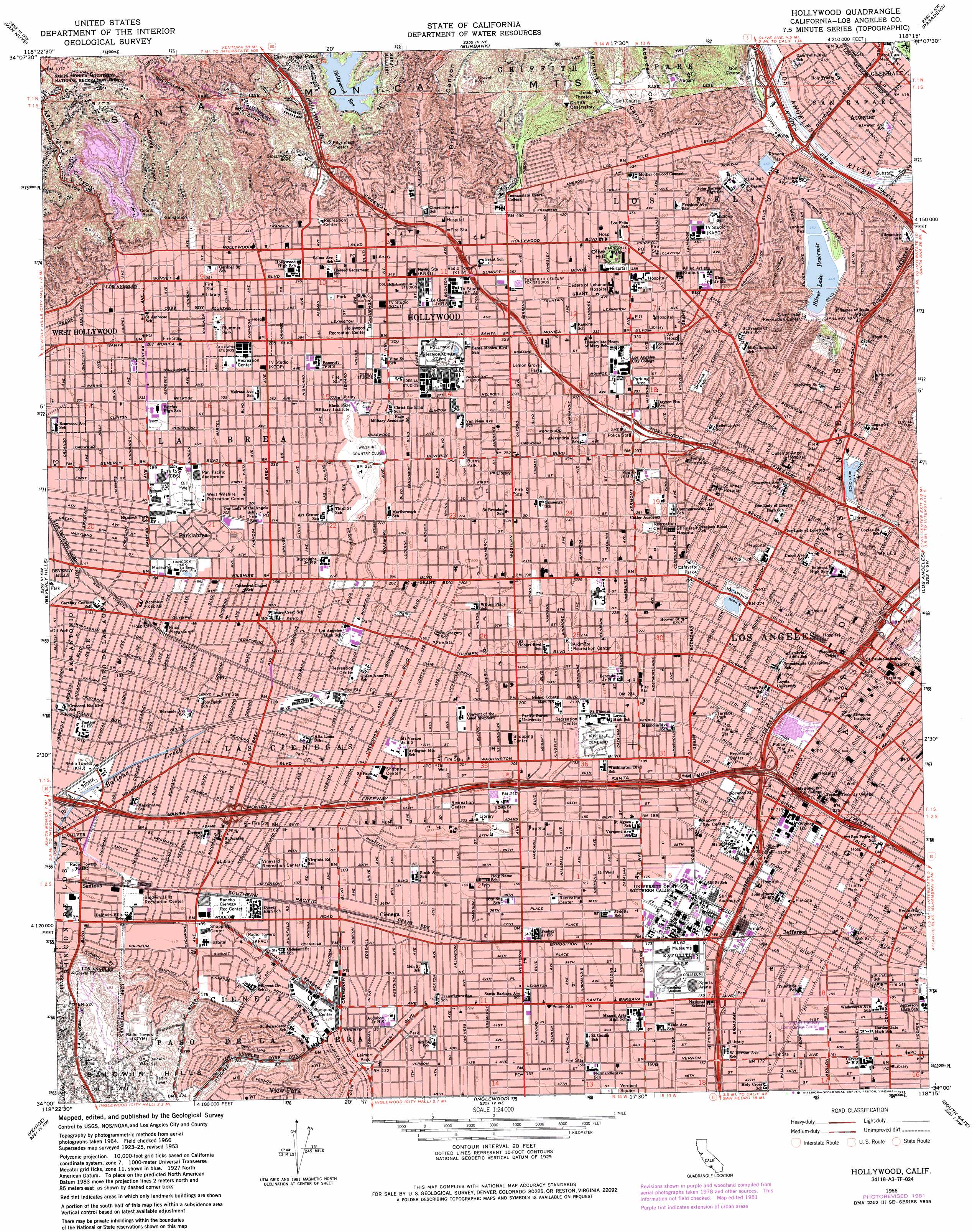
USGS Topo Quad 34118a3 - 1:24,000 scale
| Topo Map Name: | Hollywood |
| USGS Topo Quad ID: | 34118a3 |
| Print Size: | ca. 21 1/4" wide x 27" high |
| Southeast Coordinates: | 34° N latitude / 118.25° W longitude |
| Map Center Coordinates: | 34.0625° N latitude / 118.3125° W longitude |
| U.S. State: | CA |
| Filename: | o34118a3.jpg |
| Download Map JPG Image: | Hollywood topo map 1:24,000 scale |
| Map Type: | Topographic |
| Topo Series: | 7.5´ |
| Map Scale: | 1:24,000 |
| Source of Map Images: | United States Geological Survey (USGS) |
| Alternate Map Versions: |
Hollywood CA 1953, updated 1955 Download PDF Buy paper map Hollywood CA 1953, updated 1963 Download PDF Buy paper map Hollywood CA 1966, updated 1968 Download PDF Buy paper map Hollywood CA 1966, updated 1975 Download PDF Buy paper map Hollywood CA 1966, updated 1982 Download PDF Buy paper map Hollywood CA 1966, updated 1995 Download PDF Buy paper map Hollywood CA 2012 Download PDF Buy paper map Hollywood CA 2015 Download PDF Buy paper map |
1:24,000 Topo Quads surrounding Hollywood
Oat Mountain |
San Fernando |
Sunland |
Condor Peak |
Chilao Flat |
Canoga Park |
Van Nuys |
Burbank |
Pasadena |
Mount Wilson |
Topanga |
Beverly Hills |
Hollywood |
Los Angeles |
El Monte |
Venice |
Inglewood |
South Gate |
Whittier |
|
Redondo Beach |
Torrance |
Long Beach |
Los Alamitos |
> Back to 34118a1 at 1:100,000 scale
> Back to 34118a1 at 1:250,000 scale
> Back to U.S. Topo Maps home
Hollywood topo map: Gazetteer
Hollywood: Airports
ABC-TV Heliport elevation 129m 423′Arco Plaza Heliport elevation 94m 308′
B of A's Data Center Heliport elevation 106m 347′
Biltmore Hotel Heliport elevation 85m 278′
California Mart Heliport elevation 75m 246′
Chase Plaza Heliport elevation 73m 239′
Childrens Hospital Los Angeles Heliport elevation 114m 374′
City National Bank Heliport elevation 82m 269′
FIB Administration and Operations Building Heliport elevation 111m 364′
Good Samaritan Heliport elevation 105m 344′
International Tower Heliport elevation 77m 252′
J H Snyder Company III Heliport elevation 58m 190′
K and T 660 Figueroa Partners Heliport elevation 85m 278′
Operating Engineers Pension Trust Building Heliport elevation 78m 255′
Pacific Bell Heliport elevation 118m 387′
Pacific Electric Building Heliport elevation 78m 255′
Queen of Angel-Hollywood Presbyterian Hospital Heliport elevation 115m 377′
Saint Vincent Professional Office Building Heliport elevation 110m 360′
Security Pacific Plaza Heliport elevation 90m 295′
Sunset-Glendale Heliport elevation 121m 396′
The Westin Bonaventure Hotel Heliport elevation 96m 314′
United CA Bank Data Processing Operations Heliport elevation 78m 255′
Wells Fargo-CV Heliport elevation 73m 239′
Wilshire Area Heliport elevation 41m 134′
Hollywood: Crossings
Exit 10 elevation 62m 203′Exit 11A elevation 213m 698′
Exit 139B elevation 117m 383′
Exit 13A elevation 62m 203′
Exit 13B elevation 68m 223′
Exit 140A elevation 117m 383′
Exit 140B elevation 118m 387′
Exit 141A elevation 118m 387′
Exit 141B elevation 123m 403′
Exit 14A elevation 69m 226′
Exit 14B elevation 70m 229′
Exit 19 elevation 49m 160′
Exit 20A elevation 56m 183′
Exit 20B elevation 62m 203′
Exit 20C elevation 59m 193′
Exit 21 elevation 68m 223′
Exit 22A elevation 74m 242′
Exit 22B elevation 85m 278′
Exit 23A elevation 89m 291′
Exit 23B elevation 98m 321′
Exit 23C elevation 98m 321′
Exit 4A elevation 121m 396′
Exit 4B elevation 116m 380′
Exit 5A elevation 110m 360′
Exit 5B elevation 89m 291′
Exit 6A elevation 90m 295′
Exit 6B elevation 99m 324′
Exit 7 elevation 98m 321′
Exit 7B elevation 31m 101′
Exit 8 elevation 39m 127′
Exit 8A elevation 109m 357′
Exit 8B elevation 117m 383′
Exit 8C elevation 132m 433′
Exit 9 elevation 37m 121′
Exit 9A elevation 132m 433′
Exit 9B elevation 153m 501′
Hollywood: Dams
Mulholland 6-017 Dam elevation 225m 738′Rowena 6-018 Dam elevation 136m 446′
Silver Lake 6-051 Dam elevation 132m 433′
Hollywood: Gaps
Cahuenga Pass elevation 227m 744′Hollywood: Mines
La Brea Pits elevation 56m 183′Hollywood: Parks
Alumni Park elevation 57m 187′Alvarado Terrace Historic District elevation 67m 219′
Ardmore Recreation Center elevation 62m 203′
Associates Park elevation 56m 183′
Baldwin Hills Playground elevation 33m 108′
Baldwin Hills Recreation Center elevation 33m 108′
Baldwin Hills Village elevation 34m 111′
Barnsdall Park elevation 140m 459′
Bellevue Park elevation 119m 390′
Central Recreation Center elevation 69m 226′
Crocker Plaza elevation 56m 183′
David X Marks Tennis Stadium elevation 54m 177′
De Longpre Park elevation 101m 331′
Dean Bartlett Cromwell Field elevation 55m 180′
Dedeaux Field elevation 54m 177′
Denker Recreation Center elevation 49m 160′
Echo Park elevation 115m 377′
Eleanor Green Roberts Aquatic Center elevation 46m 150′
Exposition Park elevation 52m 170′
Founders Park elevation 56m 183′
Frederick D Fagg Junior Park elevation 58m 190′
Genesee Avenue Park elevation 28m 91′
Gilmore Field (historical) elevation 61m 200′
Gilmore Stadium (historical) elevation 58m 190′
Glenhurst Park elevation 111m 364′
Gramercy Park elevation 65m 213′
Grand Hope Park elevation 77m 252′
Griffith-Vermont Canyon Tennis Courts elevation 243m 797′
Hahn Plaza elevation 57m 187′
Hancock Park elevation 53m 173′
Harold A Henry Park elevation 58m 190′
Hollywood Franklin Park elevation 130m 426′
Hollywood Playground elevation 94m 308′
Hollywood Recreation Center elevation 93m 305′
Howard Jones Field elevation 54m 177′
Jim Gilliam Recreation Center elevation 54m 177′
Kenneth Hahn State Recreation Area elevation 143m 469′
Lafayette Park elevation 76m 249′
Las Palmas Playground elevation 125m 410′
Leimert Park elevation 40m 131′
Lemon Grove Park elevation 96m 314′
Leslie N Shaw Park elevation 43m 141′
Loren Miller Park elevation 54m 177′
Los Angeles High Memorial Park elevation 59m 193′
Los Angeles Swim Stadium elevation 52m 170′
MacArthur Park elevation 80m 262′
Martin Luther King Junior Park elevation 44m 144′
McDonalds Swim Stadium elevation 55m 180′
Menlo Avenue-West Twenty-ninth Street Historic District elevation 58m 190′
Normandie Playground elevation 66m 216′
North Lawn elevation 64m 209′
Parkview Playground elevation 103m 337′
Pershing Square elevation 83m 272′
Pico Union Park elevation 63m 206′
Plummer Park elevation 90m 295′
Poinsettia Playground elevation 81m 265′
Poinsettia Recreation Center elevation 81m 265′
Price Playground elevation 49m 160′
Queen Anne Recreation Center elevation 45m 147′
Rancho Cienega Recreation Center elevation 32m 104′
Robert Burns Park elevation 81m 265′
Rosewood Park elevation 65m 213′
Rudolph Valentino Memorial elevation 101m 331′
Runyon Canyon Park elevation 223m 731′
Saint James Park elevation 62m 203′
Second Avenue Park elevation 63m 206′
Shatto Recreation Center elevation 76m 249′
Silver Lake Recreation Center elevation 126m 413′
South Bonnie Brae Tract Historic District elevation 76m 249′
South Lawn elevation 63m 206′
South Serrano Avenue Historic District elevation 68m 223′
Stocker Plaza elevation 38m 124′
Terrace Park elevation 67m 219′
Thirty-Eighth and Normandie Park elevation 49m 160′
Toberman Playground elevation 64m 209′
Trinity Park elevation 66m 216′
Van Buren Place Historic District elevation 56m 183′
Vermont Square elevation 47m 154′
Vineyard Playground elevation 31m 101′
Vineyard Recreation Center elevation 31m 101′
Wattles Garden Park elevation 155m 508′
West Wilshire Playground elevation 62m 203′
West Wilshire Recreation Center elevation 63m 206′
Westside Park elevation 28m 91′
Whitley Heights Historic District elevation 170m 557′
William Mulholland Memorial elevation 123m 403′
Wilson Field elevation 51m 167′
Wilton Historic District elevation 71m 232′
Hollywood: Populated Places
Angelino Heights elevation 153m 501′Arlington Heights elevation 61m 200′
Atwater elevation 123m 403′
Baldwin Hills elevation 88m 288′
Bunker Hill Towers elevation 117m 383′
Carthay Circle elevation 44m 144′
Carthay Square elevation 40m 131′
Cienega elevation 37m 121′
Country Club Park elevation 55m 180′
Crescent elevation 74m 242′
Echo Park elevation 144m 472′
Edendale (historical) elevation 144m 472′
Hancock Park elevation 64m 209′
Harvard Heights elevation 64m 209′
Hollywood elevation 108m 354′
Hollywood Heights elevation 162m 531′
Jefferson elevation 62m 203′
Jefferson Park elevation 45m 147′
Koreatown elevation 61m 200′
Lafayette Square elevation 56m 183′
Larchmont Village elevation 74m 242′
Leimert Park elevation 37m 121′
Little Ethiopia elevation 41m 134′
Outpost Estates elevation 257m 843′
Parklabrea elevation 56m 183′
Picfair Village elevation 30m 98′
Saint James Park elevation 62m 203′
Sentous elevation 32m 104′
Silver Lake Heights elevation 169m 554′
South Carthay elevation 39m 127′
Vineyard elevation 47m 154′
West Hollywood elevation 86m 282′
Whitley Heights elevation 156m 511′
Windsor Square elevation 71m 232′
Hollywood: Post Offices
Atlantic Richfield Plaza Station Los Angeles Post Office elevation 90m 295′Baldwin Hills Post Office elevation 34m 111′
Bicentennial Station Los Angeles Post Office elevation 62m 203′
Cole Branch Los Angeles Post Office elevation 91m 298′
Crenshaw Station Los Angeles Post Office elevation 35m 114′
Del Valle Station Los Angeles Post Office elevation 73m 239′
Dockweller Station Los Angeles Post Office elevation 55m 180′
Foy Station Los Angeles Post Office elevation 89m 291′
Griffith Station Los Angeles Post Office elevation 128m 419′
Hollywood Station Los Angeles Post Office elevation 114m 374′
Los Feliz Station Los Angeles Post Office elevation 137m 449′
Metropolitan Station Los Angeles Post Office elevation 77m 252′
Miracle Mile Station Los Angeles Post Office elevation 59m 193′
Oakwood Station Los Angeles Post Office elevation 78m 255′
Pico Heights Station Los Angeles Post Office elevation 71m 232′
Ray Charles Post Office elevation 41m 134′
Ray Charles Post Office Building elevation 31m 101′
Rimpau Station Los Angeles Post Office elevation 59m 193′
Sanford Station Los Angeles Post Office elevation 67m 219′
Santa-Western Station Los Angeles Post Office elevation 107m 351′
Westvern Station Los Angeles Post Office elevation 46m 150′
Wilcox Station Los Angeles Post Office elevation 93m 305′
Hollywood: Ranges
Baldwin Hills elevation 98m 321′Hollywood: Reservoirs
Echo Lake elevation 115m 377′Hollywood Reservoir elevation 225m 738′
Ivanhoe Reservoir elevation 139m 456′
Powena Reservoir elevation 139m 456′
Silver Lake Reservoir elevation 132m 433′
Hollywood: Summits
Olive Hill elevation 141m 462′Hollywood: Valleys
Aberdeen Canyon elevation 196m 643′Brush Canyon elevation 140m 459′
Laurel Canyon elevation 146m 479′
Nichols Canyon elevation 133m 436′
Vermont Canyon elevation 178m 583′
Hollywood digital topo map on disk
Buy this Hollywood topo map showing relief, roads, GPS coordinates and other geographical features, as a high-resolution digital map file on DVD: