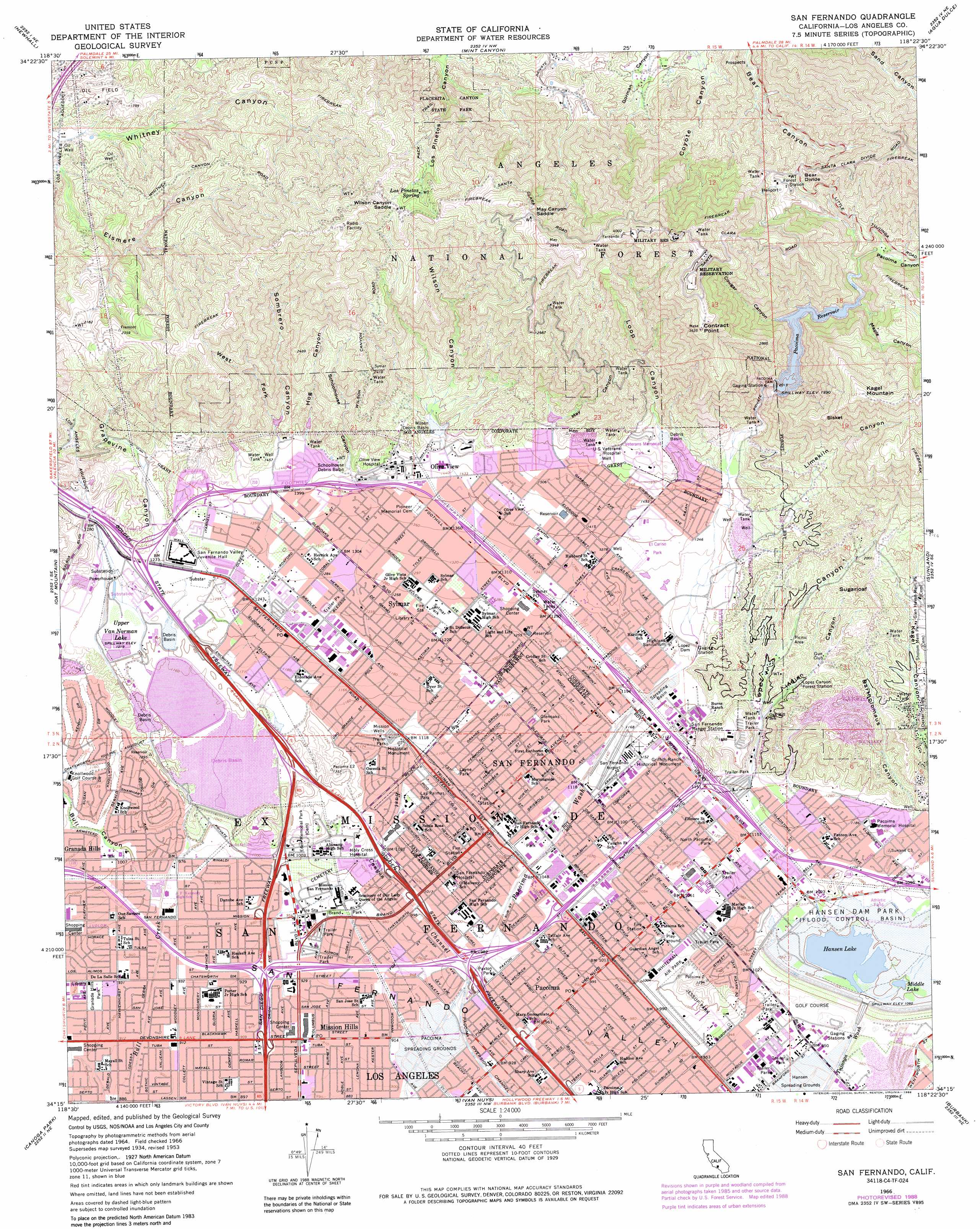
San Fernando Topo Map California
To zoom in, hover over the map of San Fernando
USGS Topo Quad 34118c4 - 1:24,000 scale
| Topo Map Name: | San Fernando |
| USGS Topo Quad ID: | 34118c4 |
| Print Size: | ca. 21 1/4" wide x 27" high |
| Southeast Coordinates: | 34.25° N latitude / 118.375° W longitude |
| Map Center Coordinates: | 34.3125° N latitude / 118.4375° W longitude |
| U.S. State: | CA |
| Filename: | o34118c4.jpg |
| Download Map JPG Image: | San Fernando topo map 1:24,000 scale |
| Map Type: | Topographic |
| Topo Series: | 7.5´ |
| Map Scale: | 1:24,000 |
| Source of Map Images: | United States Geological Survey (USGS) |
| Alternate Map Versions: |
San Fernando CA 1953, updated 1954 Download PDF Buy paper map San Fernando CA 1953, updated 1959 Download PDF Buy paper map San Fernando CA 1966, updated 1967 Download PDF Buy paper map San Fernando CA 1966, updated 1975 Download PDF Buy paper map San Fernando CA 1966, updated 1988 Download PDF Buy paper map San Fernando CA 1995, updated 1999 Download PDF Buy paper map San Fernando CA 2012 Download PDF Buy paper map San Fernando CA 2015 Download PDF Buy paper map |
| FStopo: | US Forest Service topo San Fernando is available: Download FStopo PDF Download FStopo TIF |
1:24,000 Topo Quads surrounding San Fernando
Whitaker Peak |
Warm Springs Mountain |
Green Valley |
Sleepy Valley |
Ritter Ridge |
Val Verde |
Newhall |
Mint Canyon |
Agua Dulce |
Acton |
Simi Valley East |
Oat Mountain |
San Fernando |
Sunland |
Condor Peak |
Calabasas |
Canoga Park |
Van Nuys |
Burbank |
Pasadena |
Malibu |
Topanga |
Beverly Hills |
Hollywood |
Los Angeles |
> Back to 34118a1 at 1:100,000 scale
> Back to 34118a1 at 1:250,000 scale
> Back to U.S. Topo Maps home
San Fernando topo map: Gazetteer
San Fernando: Airports
Barton Heliport elevation 301m 987′Holy Cross Medical Center Heliport elevation 313m 1026′
Lake View Medical Center Heliport elevation 356m 1167′
Merle Norman Cosmetics-Sylmar Heliport elevation 369m 1210′
San Fernando Airport (historical) elevation 351m 1151′
Whiteman Airport elevation 301m 987′
San Fernando: Areas
Achois Comihavit elevation 300m 984′San Fernando: Basins
Hansen Spreading Grounds elevation 288m 944′Lower Retention Basin elevation 344m 1128′
Pacoima Spreading Grounds elevation 282m 925′
Schoolhouse Debris Basin elevation 470m 1541′
Wilson Debris Basin elevation 470m 1541′
Yarnell Debris Basin elevation 367m 1204′
San Fernando: Capes
Bisker elevation 926m 3038′Contract Point elevation 1074m 3523′
San Fernando: Crossings
Exit 1 elevation 424m 1391′Exit 155A elevation 287m 941′
Exit 155B elevation 294m 964′
Exit 156A elevation 293m 961′
Exit 156B elevation 297m 974′
Exit 157 elevation 309m 1013′
Exit 158 elevation 358m 1174′
Exit 159 elevation 365m 1197′
Exit 2 elevation 430m 1410′
Exit 3 elevation 411m 1348′
Exit 4 elevation 393m 1289′
Exit 40B elevation 297m 974′
Exit 41 elevation 288m 944′
Exit 42A elevation 284m 931′
Exit 42B elevation 284m 931′
Exit 44A elevation 294m 964′
Exit 44B elevation 299m 980′
Exit 44C elevation 313m 1026′
Exit 45 elevation 330m 1082′
Exit 46A elevation 345m 1131′
Exit 46B elevation 352m 1154′
Exit 5 elevation 368m 1207′
Exit 6A elevation 351m 1151′
Exit 6B elevation 358m 1174′
Exit 70 elevation 278m 912′
Exit 71A elevation 281m 921′
Exit 71B elevation 290m 951′
Exit 72 elevation 309m 1013′
Exit 8 elevation 335m 1099′
San Fernando: Dams
Channel Diversion Dike 6-039 Dam elevation 362m 1187′Hansen Dam elevation 316m 1036′
Lopez Dam elevation 391m 1282′
Los Angeles Reservoir 6-050 Dam elevation 353m 1158′
Lower San Fernando 6-015 Dam elevation 345m 1131′
Lower Van Norman Bypass 6-048 Dam elevation 353m 1158′
Pacoima Dam elevation 597m 1958′
Schoolhouse Debris Dam elevation 446m 1463′
Upper San Fernando 6-028 Dam elevation 372m 1220′
Wilson Debris Dam elevation 470m 1541′
Yarnell Debris Basin 6-046 Dam elevation 369m 1210′
San Fernando: Gaps
Bear Divide elevation 819m 2687′May Canyon Saddle elevation 1087m 3566′
Wilson Canyon Saddle elevation 965m 3166′
San Fernando: Lakes
Middle Lake elevation 305m 1000′San Fernando: Parks
Andreas Pico Adobe Park elevation 290m 951′Brand Park elevation 300m 984′
Devonshire Arleta Park elevation 286m 938′
Devonwood Park elevation 280m 918′
Glenoaks Park elevation 348m 1141′
Gothic Rinaldi Park elevation 299m 980′
Granada Hills Park elevation 284m 931′
Griffith Ranch Historical Monument elevation 352m 1154′
Hubert H Humphrey Memorial Park elevation 343m 1125′
Kagel Canyon Park elevation 356m 1167′
Las Palmas Park elevation 326m 1069′
Layne Park elevation 333m 1092′
Pacoima Park elevation 314m 1030′
Paxton Park elevation 298m 977′
Recreation Park elevation 323m 1059′
Roger Jessup Recreation Center elevation 307m 1007′
Stetson Ranch Park elevation 449m 1473′
Sylmar Park elevation 386m 1266′
Veterans Memorial Park elevation 523m 1715′
San Fernando: Populated Places
El Merrie Dell elevation 433m 1420′Hickson elevation 278m 912′
Kagel Canyon elevation 391m 1282′
Mission Hills elevation 278m 912′
Olive View elevation 436m 1430′
Pacoima elevation 302m 990′
San Fernando elevation 326m 1069′
Sylmar elevation 382m 1253′
San Fernando: Post Offices
Mission Hills Post Office elevation 279m 915′Pacoima Post Office elevation 301m 987′
San Fernando Main Post Office elevation 323m 1059′
Sylmar Post Office elevation 401m 1315′
San Fernando: Reservoirs
Hansen Flood Control Basin elevation 308m 1010′Hansen Lake elevation 316m 1036′
Lower Van Norman Lake elevation 345m 1131′
Pacoima Reservoir elevation 597m 1958′
Pacoima Reservoir elevation 597m 1958′
Upper Van Norman Lake elevation 368m 1207′
Van Norman Bypass Reservoir elevation 353m 1158′
San Fernando: Springs
Los Pinetos Spring elevation 920m 3018′San Fernando: Streams
East Canyon Channel elevation 292m 958′San Fernando: Summits
Kagel Mountain elevation 1081m 3546′Sugarloaf elevation 630m 2066′
San Fernando: Valleys
Bartholomaus Canyon elevation 373m 1223′Bull Canyon elevation 297m 974′
Cougar Canyon elevation 599m 1965′
Grapevine Canyon elevation 388m 1272′
Hog Canyon elevation 465m 1525′
Indian Canyon elevation 401m 1315′
Kagel Canyon elevation 402m 1318′
Limekiln Canyon elevation 477m 1564′
Loop Canyon elevation 494m 1620′
Lopez Canyon elevation 368m 1207′
Maple Canyon elevation 620m 2034′
May Canyon elevation 516m 1692′
Pacoima Canyon elevation 610m 2001′
Schoolhouse Canyon elevation 431m 1414′
Sombrero Canyon elevation 455m 1492′
West Fork Sombrero Canyon elevation 497m 1630′
Wilson Canyon elevation 452m 1482′
San Fernando: Wells
Mission Wells elevation 344m 1128′San Fernando digital topo map on disk
Buy this San Fernando topo map showing relief, roads, GPS coordinates and other geographical features, as a high-resolution digital map file on DVD: