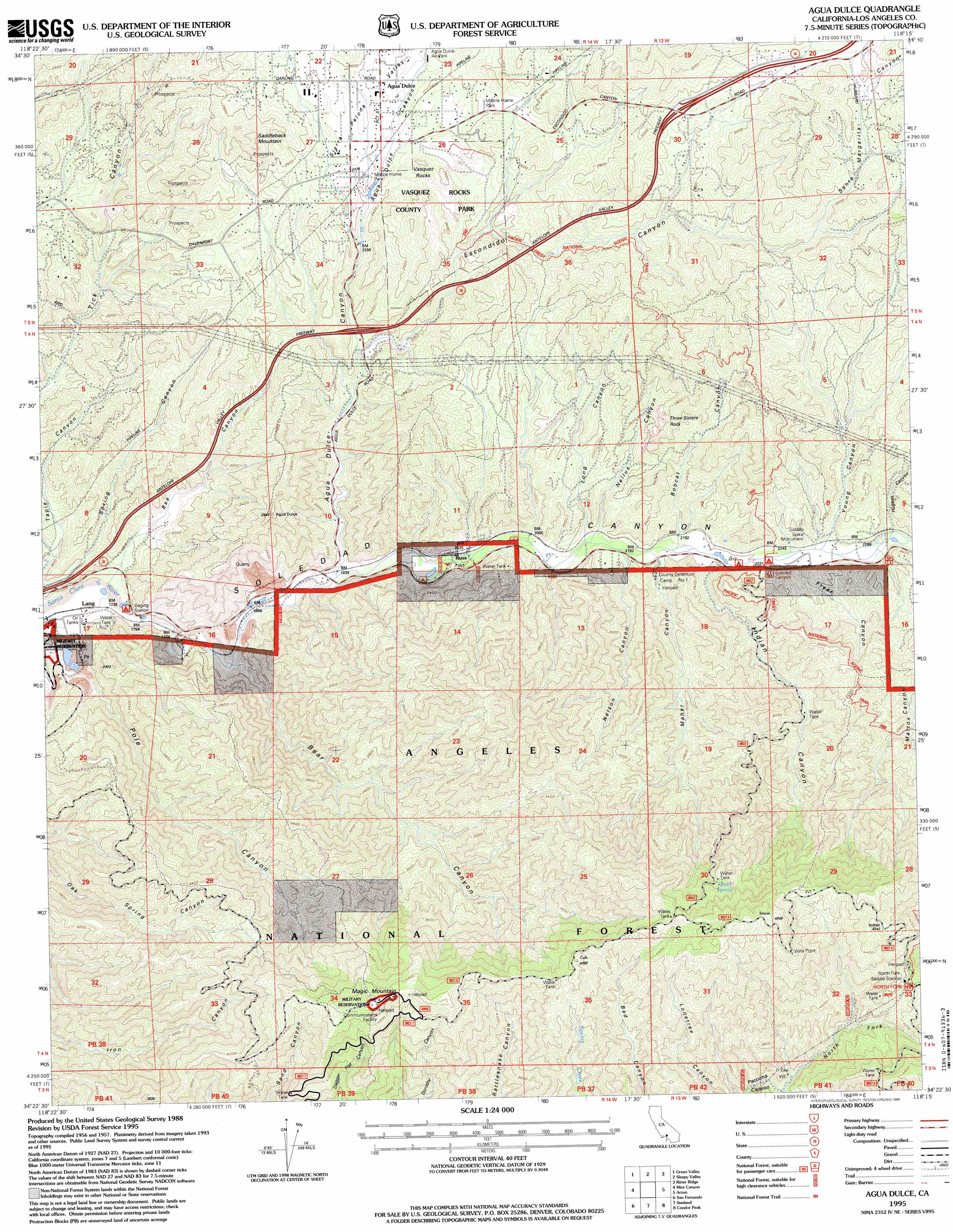
Agua Dulce Topo Map California
To zoom in, hover over the map of Agua Dulce
USGS Topo Quad 34118d3 - 1:24,000 scale
| Topo Map Name: | Agua Dulce |
| USGS Topo Quad ID: | 34118d3 |
| Print Size: | ca. 21 1/4" wide x 27" high |
| Southeast Coordinates: | 34.375° N latitude / 118.25° W longitude |
| Map Center Coordinates: | 34.4375° N latitude / 118.3125° W longitude |
| U.S. State: | CA |
| Filename: | o34118d3.jpg |
| Download Map JPG Image: | Agua Dulce topo map 1:24,000 scale |
| Map Type: | Topographic |
| Topo Series: | 7.5´ |
| Map Scale: | 1:24,000 |
| Source of Map Images: | United States Geological Survey (USGS) |
| Alternate Map Versions: |
Agua Dulce CA 1960, updated 1961 Download PDF Buy paper map Agua Dulce CA 1960, updated 1965 Download PDF Buy paper map Agua Dulce CA 1960, updated 1965 Download PDF Buy paper map Agua Dulce CA 1960, updated 1975 Download PDF Buy paper map Agua Dulce CA 1960, updated 1988 Download PDF Buy paper map Agua Dulce CA 1960, updated 1994 Download PDF Buy paper map Agua Dulce CA 1960, updated 1994 Download PDF Buy paper map Agua Dulce CA 1995, updated 1999 Download PDF Buy paper map Agua Dulce CA 2012 Download PDF Buy paper map Agua Dulce CA 2015 Download PDF Buy paper map |
| FStopo: | US Forest Service topo Agua Dulce is available: Download FStopo PDF Download FStopo TIF |
1:24,000 Topo Quads surrounding Agua Dulce
Burnt Peak |
Lake Hughes |
Del Sur |
Lancaster West |
Lancaster East |
Warm Springs Mountain |
Green Valley |
Sleepy Valley |
Ritter Ridge |
Palmdale |
Newhall |
Mint Canyon |
Agua Dulce |
Acton |
Pacifico Mountain |
Oat Mountain |
San Fernando |
Sunland |
Condor Peak |
Chilao Flat |
Canoga Park |
Van Nuys |
Burbank |
Pasadena |
Mount Wilson |
> Back to 34118a1 at 1:100,000 scale
> Back to 34118a1 at 1:250,000 scale
> Back to U.S. Topo Maps home
Agua Dulce topo map: Gazetteer
Agua Dulce: Airports
Camp 11 Heliport elevation 684m 2244′Agua Dulce: Crossings
Exit 15 elevation 686m 2250′Exit 19 elevation 888m 2913′
Agua Dulce: Forests
Angeles National Forest elevation 1489m 4885′Agua Dulce: Mines
Borax Mine elevation 709m 2326′Champion Mine elevation 782m 2565′
Agua Dulce: Parks
Cypress Park elevation 682m 2237′Vasquez Rocks Park elevation 723m 2372′
Agua Dulce: Populated Places
Agua Dulce elevation 770m 2526′Alpine (historical) elevation 586m 1922′
Russ elevation 614m 2014′
Soledad Sulphur Springs (historical) elevation 552m 1811′
Agua Dulce: Springs
Quail Spring elevation 1267m 4156′Agua Dulce: Summits
Magic Mountain elevation 1477m 4845′Saddleback Mountain elevation 930m 3051′
Three Sisters Rock elevation 897m 2942′
Vasquez Rocks elevation 797m 2614′
Agua Dulce: Valleys
Agua Dulce Canyon elevation 592m 1942′Bear Canyon elevation 556m 1824′
Bee Canyon elevation 536m 1758′
Bobcat Canyon elevation 658m 2158′
Escondido Canyon elevation 648m 2125′
Fryer Canyon elevation 694m 2276′
Hughes Canyon elevation 690m 2263′
Indian Canyon elevation 672m 2204′
Long Canyon elevation 635m 2083′
Maher Canyon elevation 666m 2185′
Mattox Canyon elevation 783m 2568′
Nellus Canyon elevation 640m 2099′
Nelson Canyon elevation 653m 2142′
North Fork Pacoima Canyon elevation 1060m 3477′
Pole Canyon elevation 532m 1745′
Santa Margarita Canyon elevation 873m 2864′
Sierra Pelona Valley elevation 701m 2299′
Young Canyon elevation 691m 2267′
Agua Dulce digital topo map on disk
Buy this Agua Dulce topo map showing relief, roads, GPS coordinates and other geographical features, as a high-resolution digital map file on DVD: