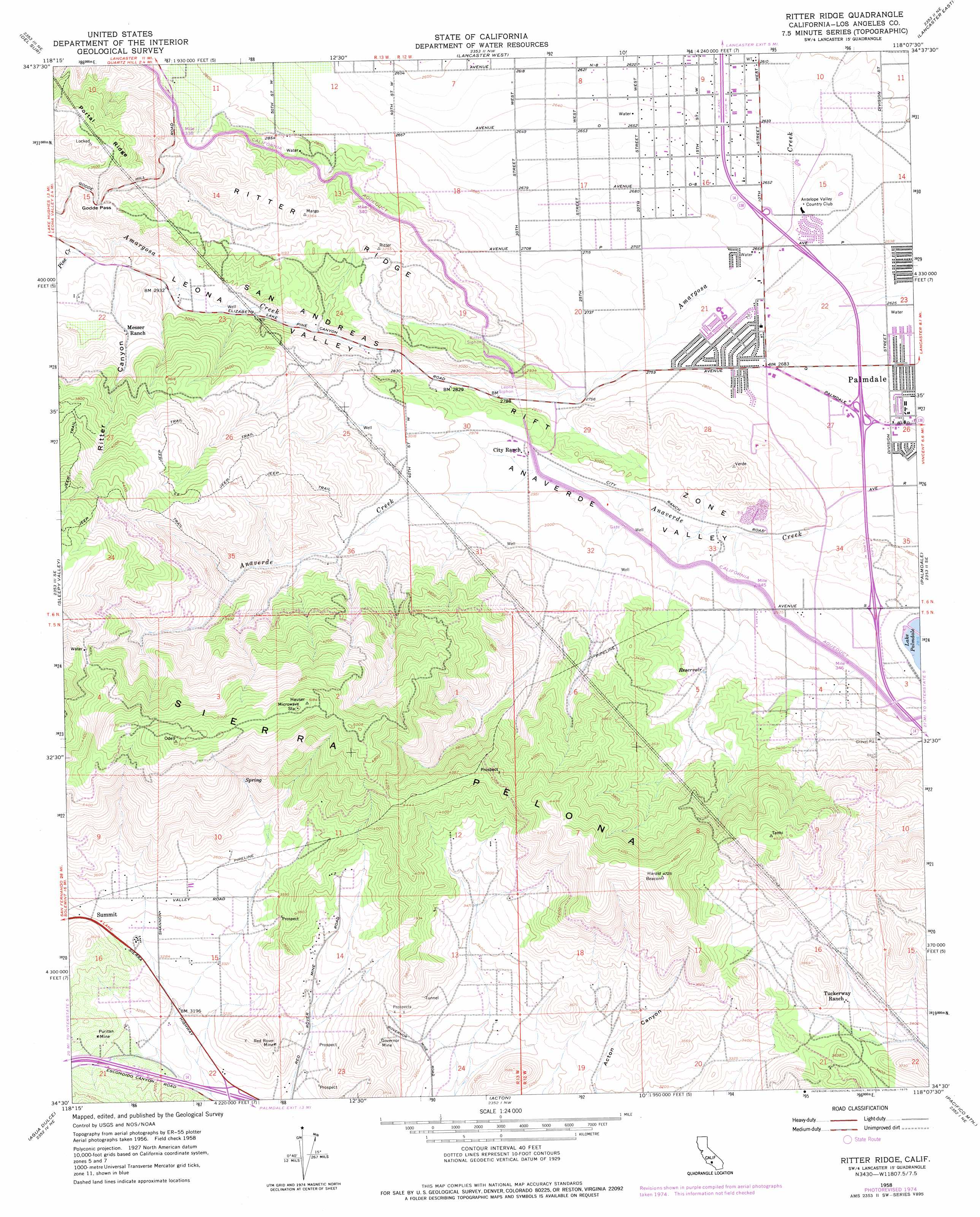
Ritter Ridge Topo Map California
To zoom in, hover over the map of Ritter Ridge
USGS Topo Quad 34118e2 - 1:24,000 scale
| Topo Map Name: | Ritter Ridge |
| USGS Topo Quad ID: | 34118e2 |
| Print Size: | ca. 21 1/4" wide x 27" high |
| Southeast Coordinates: | 34.5° N latitude / 118.125° W longitude |
| Map Center Coordinates: | 34.5625° N latitude / 118.1875° W longitude |
| U.S. State: | CA |
| Filename: | o34118e2.jpg |
| Download Map JPG Image: | Ritter Ridge topo map 1:24,000 scale |
| Map Type: | Topographic |
| Topo Series: | 7.5´ |
| Map Scale: | 1:24,000 |
| Source of Map Images: | United States Geological Survey (USGS) |
| Alternate Map Versions: |
Ritter Ridge CA 1958, updated 1965 Download PDF Buy paper map Ritter Ridge CA 1958, updated 1975 Download PDF Buy paper map Ritter Ridge CA 2012 Download PDF Buy paper map Ritter Ridge CA 2015 Download PDF Buy paper map |
1:24,000 Topo Quads surrounding Ritter Ridge
Fairmont Butte |
Little Buttes |
Rosamond |
Rosamond Lake |
Redman |
Lake Hughes |
Del Sur |
Lancaster West |
Lancaster East |
Alpine Butte |
Green Valley |
Sleepy Valley |
Ritter Ridge |
Palmdale |
Littlerock |
Mint Canyon |
Agua Dulce |
Acton |
Pacifico Mountain |
Juniper Hills |
San Fernando |
Sunland |
Condor Peak |
Chilao Flat |
Waterman Mountain |
> Back to 34118e1 at 1:100,000 scale
> Back to 34118a1 at 1:250,000 scale
> Back to U.S. Topo Maps home
Ritter Ridge topo map: Gazetteer
Ritter Ridge: Canals
Leona Siphon elevation 847m 2778′Ritter Siphon elevation 871m 2857′
Ritter Ridge: Crossings
Exit 22 elevation 932m 3057′Exit 33 elevation 870m 2854′
Exit 35 elevation 819m 2687′
Exit 37 elevation 813m 2667′
Ritter Ridge: Gaps
Godde Pass elevation 1032m 3385′Ritter Ridge: Mines
Governor Mine elevation 1072m 3517′Puritan Mine elevation 1001m 3284′
Red Rover Mine elevation 1014m 3326′
Ritter Ridge: Populated Places
Desert View Highlands elevation 827m 2713′Lakeview elevation 889m 2916′
Mission elevation 1015m 3330′
Rancho Vista elevation 839m 2752′
Ritter Ridge: Streams
Anaverde Creek elevation 839m 2752′Pine Creek elevation 904m 2965′
Ritter Ridge: Valleys
Anaverde Valley elevation 878m 2880′Leona Valley elevation 843m 2765′
Ritter Canyon elevation 922m 3024′
Ritter Ridge digital topo map on disk
Buy this Ritter Ridge topo map showing relief, roads, GPS coordinates and other geographical features, as a high-resolution digital map file on DVD: