Del Sur Topo Map California
To zoom in, hover over the map of Del Sur
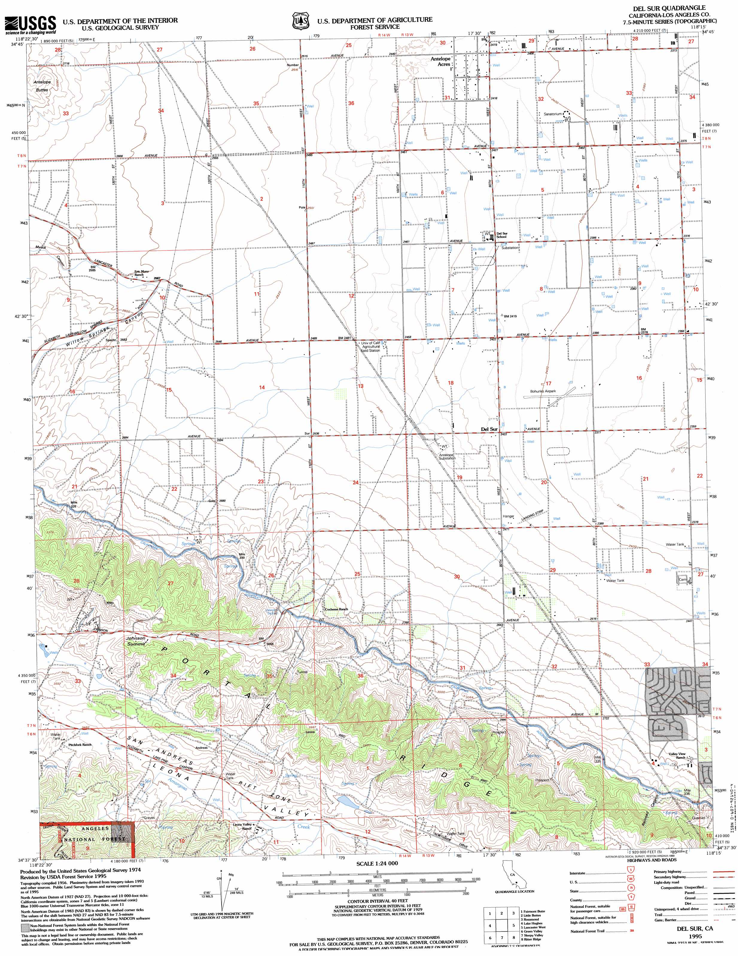
USGS Topo Quad 34118f3 - 1:24,000 scale
| Topo Map Name: | Del Sur |
| USGS Topo Quad ID: | 34118f3 |
| Print Size: | ca. 21 1/4" wide x 27" high |
| Southeast Coordinates: | 34.625° N latitude / 118.25° W longitude |
| Map Center Coordinates: | 34.6875° N latitude / 118.3125° W longitude |
| U.S. State: | CA |
| Filename: | o34118f3.jpg |
| Download Map JPG Image: | Del Sur topo map 1:24,000 scale |
| Map Type: | Topographic |
| Topo Series: | 7.5´ |
| Map Scale: | 1:24,000 |
| Source of Map Images: | United States Geological Survey (USGS) |
| Alternate Map Versions: |
Del Sur CA 1958, updated 1959 Download PDF Buy paper map Del Sur CA 1958, updated 1964 Download PDF Buy paper map Del Sur CA 1958, updated 1964 Download PDF Buy paper map Del Sur CA 1958, updated 1975 Download PDF Buy paper map Del Sur CA 1995, updated 1999 Download PDF Buy paper map Del Sur CA 2012 Download PDF Buy paper map Del Sur CA 2015 Download PDF Buy paper map |
| FStopo: | US Forest Service topo Del Sur is available: Download FStopo PDF Download FStopo TIF |
1:24,000 Topo Quads surrounding Del Sur
Liebre Twins |
Tylerhorse Canyon |
Willow Springs |
Soledad Mountain |
Bissell |
Neenach School |
Fairmont Butte |
Little Buttes |
Rosamond |
Rosamond Lake |
Burnt Peak |
Lake Hughes |
Del Sur |
Lancaster West |
Lancaster East |
Warm Springs Mountain |
Green Valley |
Sleepy Valley |
Ritter Ridge |
Palmdale |
Newhall |
Mint Canyon |
Agua Dulce |
Acton |
Pacifico Mountain |
> Back to 34118e1 at 1:100,000 scale
> Back to 34118a1 at 1:250,000 scale
> Back to U.S. Topo Maps home
Del Sur topo map: Gazetteer
Del Sur: Airports
Bohunks Airpark elevation 734m 2408′Del Sur: Canals
Johnson Siphon elevation 899m 2949′Del Sur: Gaps
Johnson Summit elevation 1081m 3546′Del Sur: Populated Places
Del Sur elevation 738m 2421′Del Sur: Ridges
Portal Ridge elevation 1129m 3704′Del Sur: Valleys
Myrick Canyon elevation 788m 2585′Railroad Canyon elevation 900m 2952′
Willow Springs Canyon elevation 789m 2588′
Del Sur digital topo map on disk
Buy this Del Sur topo map showing relief, roads, GPS coordinates and other geographical features, as a high-resolution digital map file on DVD: