Little Pine Mountain Topo Map California
To zoom in, hover over the map of Little Pine Mountain
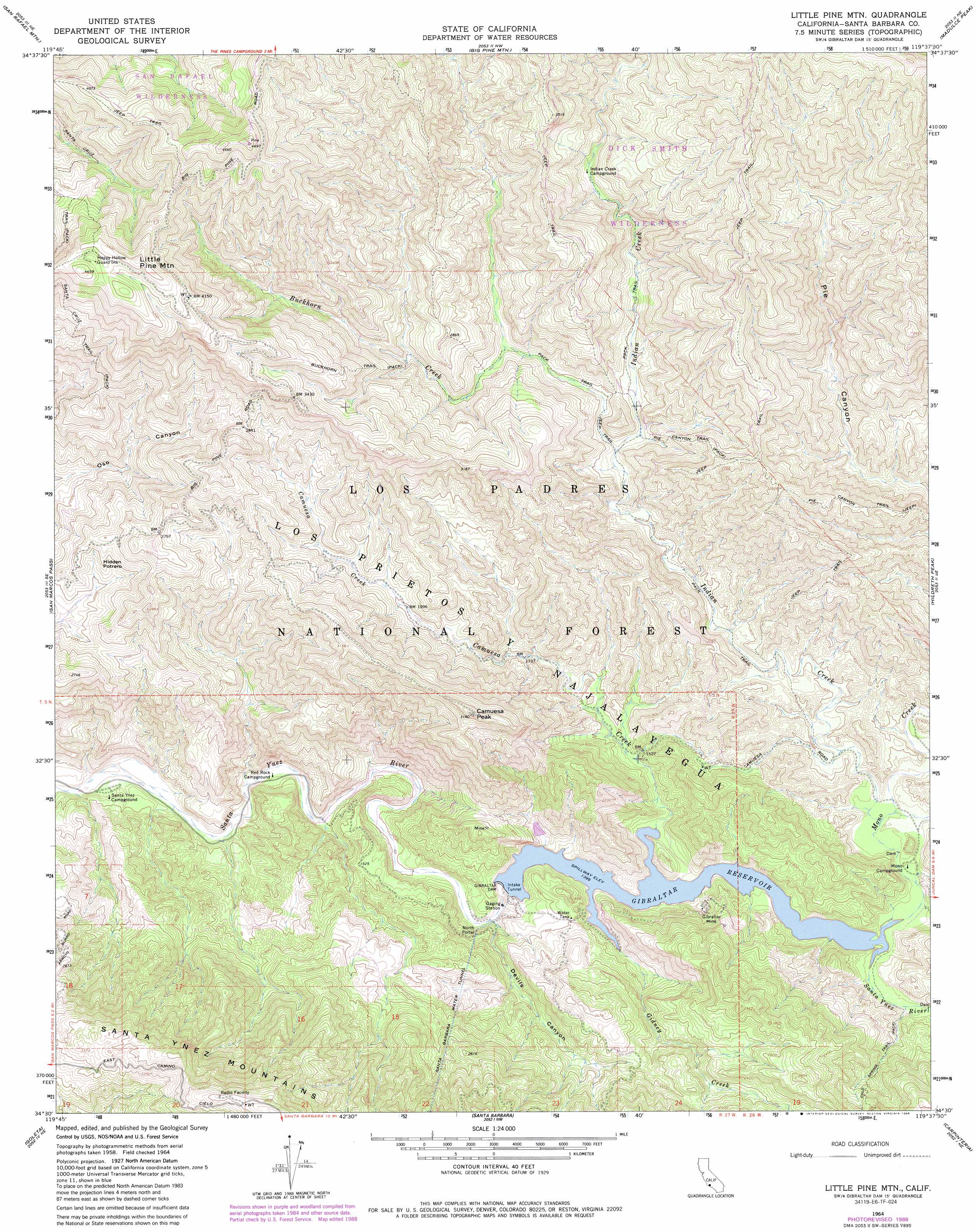
USGS Topo Quad 34119e6 - 1:24,000 scale
| Topo Map Name: | Little Pine Mountain |
| USGS Topo Quad ID: | 34119e6 |
| Print Size: | ca. 21 1/4" wide x 27" high |
| Southeast Coordinates: | 34.5° N latitude / 119.625° W longitude |
| Map Center Coordinates: | 34.5625° N latitude / 119.6875° W longitude |
| U.S. State: | CA |
| Filename: | o34119e6.jpg |
| Download Map JPG Image: | Little Pine Mountain topo map 1:24,000 scale |
| Map Type: | Topographic |
| Topo Series: | 7.5´ |
| Map Scale: | 1:24,000 |
| Source of Map Images: | United States Geological Survey (USGS) |
| Alternate Map Versions: |
Little Pine Mountain CA 1942, updated 1964 Download PDF Buy paper map Little Pine Mountain CA 1964, updated 1966 Download PDF Buy paper map Little Pine Mountain CA 1964, updated 1972 Download PDF Buy paper map Little Pine Mountain CA 1964, updated 1986 Download PDF Buy paper map Little Pine Mountain CA 1964, updated 1988 Download PDF Buy paper map Little Pine Mountain CA 1995, updated 2000 Download PDF Buy paper map Little Pine Mountain CA 2012 Download PDF Buy paper map Little Pine Mountain CA 2015 Download PDF Buy paper map |
| FStopo: | US Forest Service topo Little Pine Mountain is available: Download FStopo PDF Download FStopo TIF |
1:24,000 Topo Quads surrounding Little Pine Mountain
Bald Mountain |
Hurricane Deck |
Salisbury Potrero |
Fox Mountain |
Cuyama Peak |
Figueroa Mountain |
San Rafael Mountain |
Big Pine Mountain |
Madulce Peak |
Rancho Nuevo Creek |
Lake Cachuma |
San Marcos Pass |
Little Pine Mountain |
Hildreth Peak |
Old Man Mountain |
Dos Pueblos Canyon |
Goleta |
Santa Barbara |
Carpinteria |
White Ledge Peak |
Pitas Point |
> Back to 34119e1 at 1:100,000 scale
> Back to 34118a1 at 1:250,000 scale
> Back to U.S. Topo Maps home
Little Pine Mountain topo map: Gazetteer
Little Pine Mountain: Dams
Gibraltar Dam elevation 428m 1404′Mono Debris Dam elevation 440m 1443′
Little Pine Mountain: Flats
Gidney Flat elevation 389m 1276′Hidden Potrero elevation 716m 2349′
Little Pine Mountain: Gaps
Matias Potrero elevation 466m 1528′Little Pine Mountain: Mines
Gibraltar Mine elevation 504m 1653′Little Pine Mountain: Reservoirs
Gibraltar Reservoir elevation 427m 1400′Little Pine Mountain: Streams
Buckhorn Creek elevation 589m 1932′Camuesa Creek elevation 427m 1400′
Gidney Creek elevation 427m 1400′
Indian Creek elevation 448m 1469′
Mono Creek elevation 427m 1400′
Little Pine Mountain: Summits
Camuesa Peak elevation 962m 3156′Little Pine Mountain elevation 1368m 4488′
Little Pine Mountain: Trails
Buckhorn Trail elevation 926m 3038′Pie Canyon Trail elevation 844m 2769′
Pie Canyon Trail elevation 725m 2378′
Little Pine Mountain: Tunnels
North Portal elevation 395m 1295′Little Pine Mountain: Valleys
Camuesa Canyon elevation 427m 1400′Devils Canyon elevation 392m 1286′
Little Caliente Canyon elevation 451m 1479′
Little Pine Mountain digital topo map on disk
Buy this Little Pine Mountain topo map showing relief, roads, GPS coordinates and other geographical features, as a high-resolution digital map file on DVD: