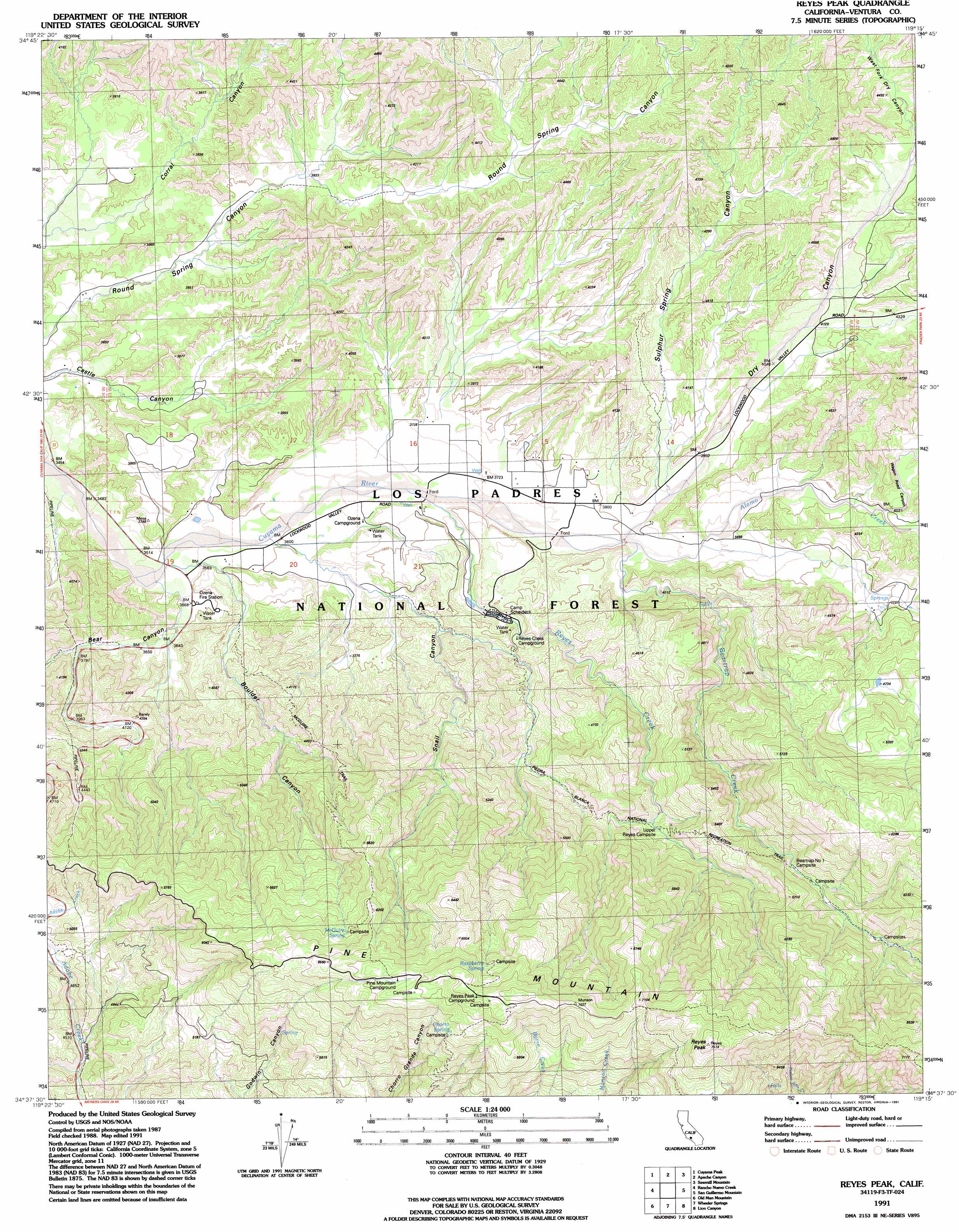
Reyes Peak Topo Map California
To zoom in, hover over the map of Reyes Peak
USGS Topo Quad 34119f3 - 1:24,000 scale
| Topo Map Name: | Reyes Peak |
| USGS Topo Quad ID: | 34119f3 |
| Print Size: | ca. 21 1/4" wide x 27" high |
| Southeast Coordinates: | 34.625° N latitude / 119.25° W longitude |
| Map Center Coordinates: | 34.6875° N latitude / 119.3125° W longitude |
| U.S. State: | CA |
| Filename: | o34119f3.jpg |
| Download Map JPG Image: | Reyes Peak topo map 1:24,000 scale |
| Map Type: | Topographic |
| Topo Series: | 7.5´ |
| Map Scale: | 1:24,000 |
| Source of Map Images: | United States Geological Survey (USGS) |
| Alternate Map Versions: |
Reyes Peak CA 1943, updated 1959 Download PDF Buy paper map Reyes Peak CA 1943, updated 1967 Download PDF Buy paper map Reyes Peak CA 1991, updated 1991 Download PDF Buy paper map Reyes Peak CA 1991, updated 1991 Download PDF Buy paper map Reyes Peak CA 1995, updated 2000 Download PDF Buy paper map Reyes Peak CA 2012 Download PDF Buy paper map Reyes Peak CA 2015 Download PDF Buy paper map |
| FStopo: | US Forest Service topo Reyes Peak is available: Download FStopo PDF Download FStopo TIF |
1:24,000 Topo Quads surrounding Reyes Peak
Cuyama |
Ballinger Canyon |
Santiago Creek |
Eagle Rest Peak |
Pleito Hills |
Fox Mountain |
Cuyama Peak |
Apache Canyon |
Sawmill Mountain |
Cuddy Valley |
Madulce Peak |
Rancho Nuevo Creek |
Reyes Peak |
San Guillermo |
Lockwood Valley |
Hildreth Peak |
Old Man Mountain |
Wheeler Springs |
Lion Canyon |
Topatopa Mountains |
Carpinteria |
White Ledge Peak |
Matilija |
Ojai |
Santa Paula Peak |
> Back to 34119e1 at 1:100,000 scale
> Back to 34118a1 at 1:250,000 scale
> Back to U.S. Topo Maps home
Reyes Peak topo map: Gazetteer
Reyes Peak: Ridges
Pine Mountain elevation 2209m 7247′Reyes Peak: Springs
Chorro Spring elevation 1132m 3713′McGuire Spring elevation 1815m 5954′
McGurie Spring elevation 1621m 5318′
Raspberry Spring elevation 2021m 6630′
Reyes Peak: Streams
Alamo Creek elevation 1160m 3805′Beartrap Creek elevation 1160m 3805′
Reyes Creek elevation 1117m 3664′
Reyes Peak: Summits
Reyes Peak elevation 2284m 7493′Reyes Peak: Trails
McGuire Trail elevation 1467m 4812′Reyes Peak: Valleys
Bear Canyon elevation 1081m 3546′Boulder Canyon elevation 1092m 3582′
Dry Canyon elevation 1160m 3805′
Snail Canyon elevation 1095m 3592′
Sulphur Spring Canyon elevation 1182m 3877′
Wagon Road Canyon elevation 1222m 4009′
West Fork Dry Canyon elevation 1330m 4363′
Reyes Peak digital topo map on disk
Buy this Reyes Peak topo map showing relief, roads, GPS coordinates and other geographical features, as a high-resolution digital map file on DVD: