Sisquoc Topo Map California
To zoom in, hover over the map of Sisquoc
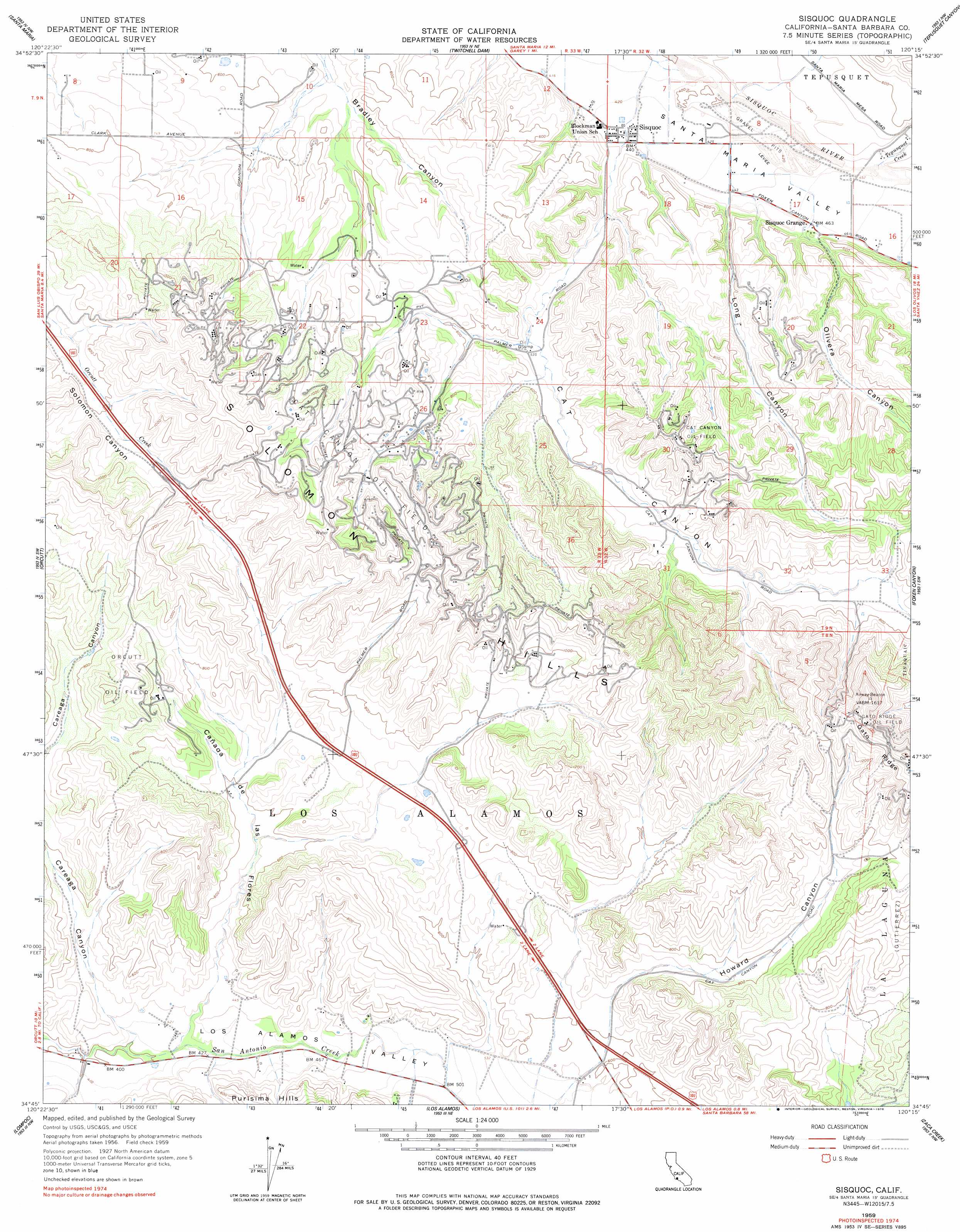
USGS Topo Quad 34120g3 - 1:24,000 scale
| Topo Map Name: | Sisquoc |
| USGS Topo Quad ID: | 34120g3 |
| Print Size: | ca. 21 1/4" wide x 27" high |
| Southeast Coordinates: | 34.75° N latitude / 120.25° W longitude |
| Map Center Coordinates: | 34.8125° N latitude / 120.3125° W longitude |
| U.S. State: | CA |
| Filename: | o34120g3.jpg |
| Download Map JPG Image: | Sisquoc topo map 1:24,000 scale |
| Map Type: | Topographic |
| Topo Series: | 7.5´ |
| Map Scale: | 1:24,000 |
| Source of Map Images: | United States Geological Survey (USGS) |
| Alternate Map Versions: |
Careaga Canyon CA 1947, updated 1947 Download PDF Buy paper map Careaga Canyon CA 1947, updated 1947 Download PDF Buy paper map Sisquoc CA 1959, updated 1960 Download PDF Buy paper map Sisquoc CA 1959, updated 1978 Download PDF Buy paper map Sisquoc CA 1959, updated 1978 Download PDF Buy paper map Sisquoc CA 2012 Download PDF Buy paper map Sisquoc CA 2015 Download PDF Buy paper map |
1:24,000 Topo Quads surrounding Sisquoc
Oceano |
Nipomo |
Huasna Peak |
Chimney Canyon |
Miranda Pine Mountain |
Guadalupe |
Santa Maria |
Twitchell Dam |
Tepusquet Canyon |
Manzanita Mountain |
Casmalia |
Orcutt |
Sisquoc |
Foxen Canyon |
Zaca Lake |
Surf |
Lompoc |
Los Alamos |
Zaca Creek |
Los Olivos |
Tranquillon Mountain |
Lompoc Hills |
Santa Rosa Hills |
Solvang |
Santa Ynez |
> Back to 34120e1 at 1:100,000 scale
> Back to 34120a1 at 1:250,000 scale
> Back to U.S. Topo Maps home
Sisquoc topo map: Gazetteer
Sisquoc: Oilfields
Cat Canyon Oil Field elevation 272m 892′Sisquoc: Populated Places
Palmer (historical) elevation 260m 853′Roadamite (historical) elevation 234m 767′
Sisquoc elevation 133m 436′
Sisquoc: Streams
Tepusquet Creek elevation 138m 452′Sisquoc: Valleys
Cañada de las Flores elevation 126m 413′Cat Canyon elevation 141m 462′
Howard Canyon elevation 196m 643′
Long Canyon elevation 136m 446′
Olivera Canyon elevation 140m 459′
Sisquoc digital topo map on disk
Buy this Sisquoc topo map showing relief, roads, GPS coordinates and other geographical features, as a high-resolution digital map file on DVD: