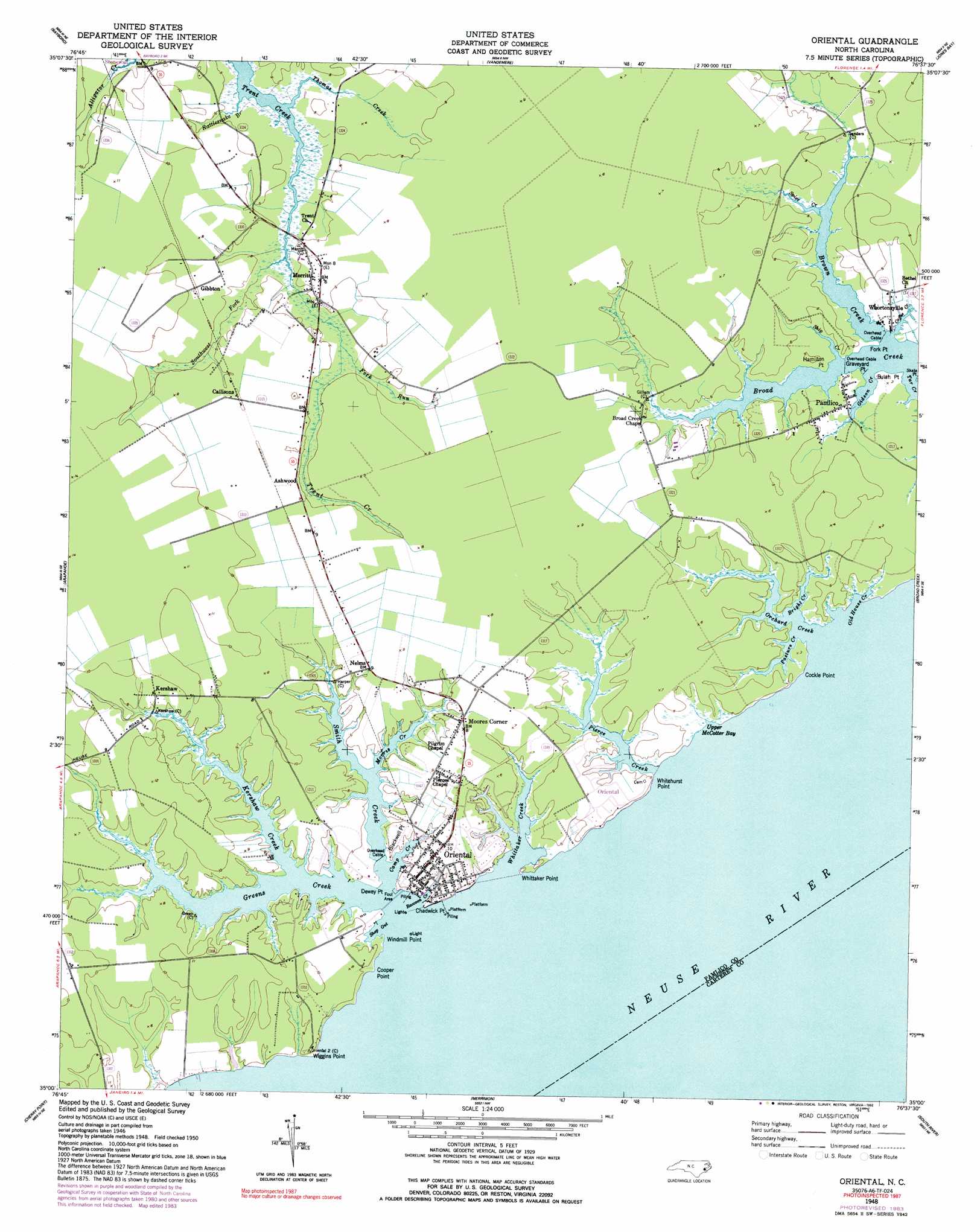
Oriental Topo Map North Carolina
To zoom in, hover over the map of Oriental
USGS Topo Quad 35076a6 - 1:24,000 scale
| Topo Map Name: | Oriental |
| USGS Topo Quad ID: | 35076a6 |
| Print Size: | ca. 21 1/4" wide x 27" high |
| Southeast Coordinates: | 35° N latitude / 76.625° W longitude |
| Map Center Coordinates: | 35.0625° N latitude / 76.6875° W longitude |
| U.S. State: | NC |
| Filename: | o35076a6.jpg |
| Download Map JPG Image: | Oriental topo map 1:24,000 scale |
| Map Type: | Topographic |
| Topo Series: | 7.5´ |
| Map Scale: | 1:24,000 |
| Source of Map Images: | United States Geological Survey (USGS) |
| Alternate Map Versions: |
Oriental NC 1948, updated 1992 Download PDF Buy paper map Oriental NC 2010 Download PDF Buy paper map Oriental NC 2013 Download PDF Buy paper map Oriental NC 2016 Download PDF Buy paper map |
1:24,000 Topo Quads surrounding Oriental
Edward |
Aurora |
South Creek |
Lowland |
Pamlico Point |
Reelsboro |
Bayboro |
Vandemere |
Jones Bay |
Little Fishing Point |
Upper Broad Creek |
Arapahoe |
Oriental |
Broad Creek |
Point Of Marsh |
Havelock |
Cherry Point |
Merrimon |
South River |
Long Bay |
Masontown |
Newport |
Core Creek |
Williston |
Davis |
> Back to 35076a1 at 1:100,000 scale
> Back to 35076a1 at 1:250,000 scale
> Back to U.S. Topo Maps home
Oriental topo map: Gazetteer
Oriental: Bays
Raccoon Creek elevation 2m 6′Shop Gut elevation 0m 0′
Upper McCotter Bay elevation 0m 0′
Oriental: Capes
Blackwell Point elevation 2m 6′Bulah Point elevation 1m 3′
Chadwick Point elevation 1m 3′
Cockle Point elevation 0m 0′
Cooper Point elevation 0m 0′
Dewey Point elevation 2m 6′
Fork Point elevation 1m 3′
Graveyard Point elevation 0m 0′
Hamilton Point elevation 0m 0′
Piney Point elevation 3m 9′
Whitehurst Point elevation 0m 0′
Whittaker Point elevation 0m 0′
Wiggins Point elevation 1m 3′
Windmill Point elevation 0m 0′
Oriental: Populated Places
Ashwood elevation 2m 6′Callisons elevation 3m 9′
Gibbton elevation 2m 6′
Kershaw elevation 2m 6′
Merritt elevation 1m 3′
Moores Corner elevation 2m 6′
Nelms elevation 2m 6′
Oriental elevation 3m 9′
Pamlico elevation 1m 3′
Whortonsville elevation 1m 3′
Oriental: Streams
Bright Creek elevation 0m 0′Brown Creek elevation 1m 3′
Camp Creek elevation 2m 6′
Coffee Creek elevation 0m 0′
Fork Run elevation 0m 0′
Gideon Creek elevation 0m 0′
Greens Creek elevation 0m 0′
Kershaw Creek elevation 0m 0′
Morris Creek elevation 0m 0′
Old House Creek elevation 3m 9′
Orchard Creek elevation 0m 0′
Pasture Creek elevation 1m 3′
Pierce Creek elevation 0m 0′
Rattlesnake Branch elevation 0m 0′
Ship Creek elevation 1m 3′
Smith Creek elevation 0m 0′
Southwest Fork Trent Creek elevation 0m 0′
Spice Creek elevation 1m 3′
Thomas Creek elevation 0m 0′
Whittaker Creek elevation 0m 0′
Oriental digital topo map on disk
Buy this Oriental topo map showing relief, roads, GPS coordinates and other geographical features, as a high-resolution digital map file on DVD:
Atlantic Coast (NY, NJ, PA, DE, MD, VA, NC)
Buy digital topo maps: Atlantic Coast (NY, NJ, PA, DE, MD, VA, NC)
 map DVD")