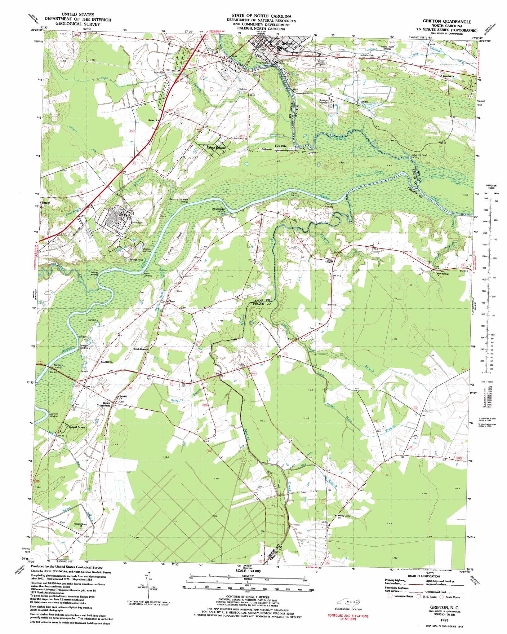
Grifton Topo Map North Carolina
To zoom in, hover over the map of Grifton
USGS Topo Quad 35077c4 - 1:24,000 scale
| Topo Map Name: | Grifton |
| USGS Topo Quad ID: | 35077c4 |
| Print Size: | ca. 21 1/4" wide x 27" high |
| Southeast Coordinates: | 35.25° N latitude / 77.375° W longitude |
| Map Center Coordinates: | 35.3125° N latitude / 77.4375° W longitude |
| U.S. State: | NC |
| Filename: | o35077c4.jpg |
| Download Map JPG Image: | Grifton topo map 1:24,000 scale |
| Map Type: | Topographic |
| Topo Series: | 7.5´ |
| Map Scale: | 1:24,000 |
| Source of Map Images: | United States Geological Survey (USGS) |
| Alternate Map Versions: |
Grifton NC 1983, updated 1983 Download PDF Buy paper map Grifton NC 2010 Download PDF Buy paper map Grifton NC 2013 Download PDF Buy paper map Grifton NC 2016 Download PDF Buy paper map |
1:24,000 Topo Quads surrounding Grifton
Walstonburg |
Farmville |
Greenville Sw |
Greenville Se |
Grimesland |
Snow Hill |
Hookerton |
Ayden |
Gardnerville |
Wilmar |
Falling Creek |
Kinston |
Grifton |
Fort Barnwell |
Vanceboro |
Deep Run |
Rivermont |
Dover |
Cove City |
Jasper |
Pink Hill |
Comfort |
Phillips Crossroads |
Trenton |
Pollocksville |
> Back to 35077a1 at 1:100,000 scale
> Back to 35076a1 at 1:250,000 scale
> Back to U.S. Topo Maps home
Grifton topo map: Gazetteer
Grifton: Bays
Doughertys Cove elevation 3m 9′Grifton: Bridges
Oak Bridge elevation 3m 9′Grifton: Canals
Alligator Canal elevation 11m 36′Channel 7 Canal elevation 8m 26′
Cox Canal elevation 11m 36′
Rhem Canal elevation 10m 32′
Grifton: Channels
Alligator Canal elevation 11m 36′Grifton: Islands
Clark Field elevation 8m 26′Grifton: Populated Places
Closs elevation 8m 26′Grifton elevation 8m 26′
John Hill Mobile Home Park elevation 11m 36′
Royal Acres elevation 9m 29′
Tick Bite elevation 6m 19′
Urban Estates elevation 8m 26′
West Crossroads elevation 9m 29′
Grifton: Post Offices
Grifton Post Office elevation 9m 29′Grifton: Streams
Alligator Branch elevation 4m 13′Alum Springs Branch elevation 2m 6′
Beaverdam Branch elevation 2m 6′
Bone Gray Branch elevation 2m 6′
Contentnea Creek elevation 4m 13′
Eagle Swamp elevation 2m 6′
Folley Branch elevation 11m 36′
Grinnel Slough elevation 2m 6′
Harrys Branch elevation 9m 29′
Jacks Slough elevation 0m 0′
Little Snake Hole Branch elevation 9m 29′
Mosley Creek elevation 4m 13′
Snake Hole Branch elevation 6m 19′
Stonyton Creek elevation 2m 6′
Tracey Swamp elevation 12m 39′
Grifton digital topo map on disk
Buy this Grifton topo map showing relief, roads, GPS coordinates and other geographical features, as a high-resolution digital map file on DVD:
Atlantic Coast (NY, NJ, PA, DE, MD, VA, NC)
Buy digital topo maps: Atlantic Coast (NY, NJ, PA, DE, MD, VA, NC)
 map DVD")