Pinetops Topo Map North Carolina
To zoom in, hover over the map of Pinetops
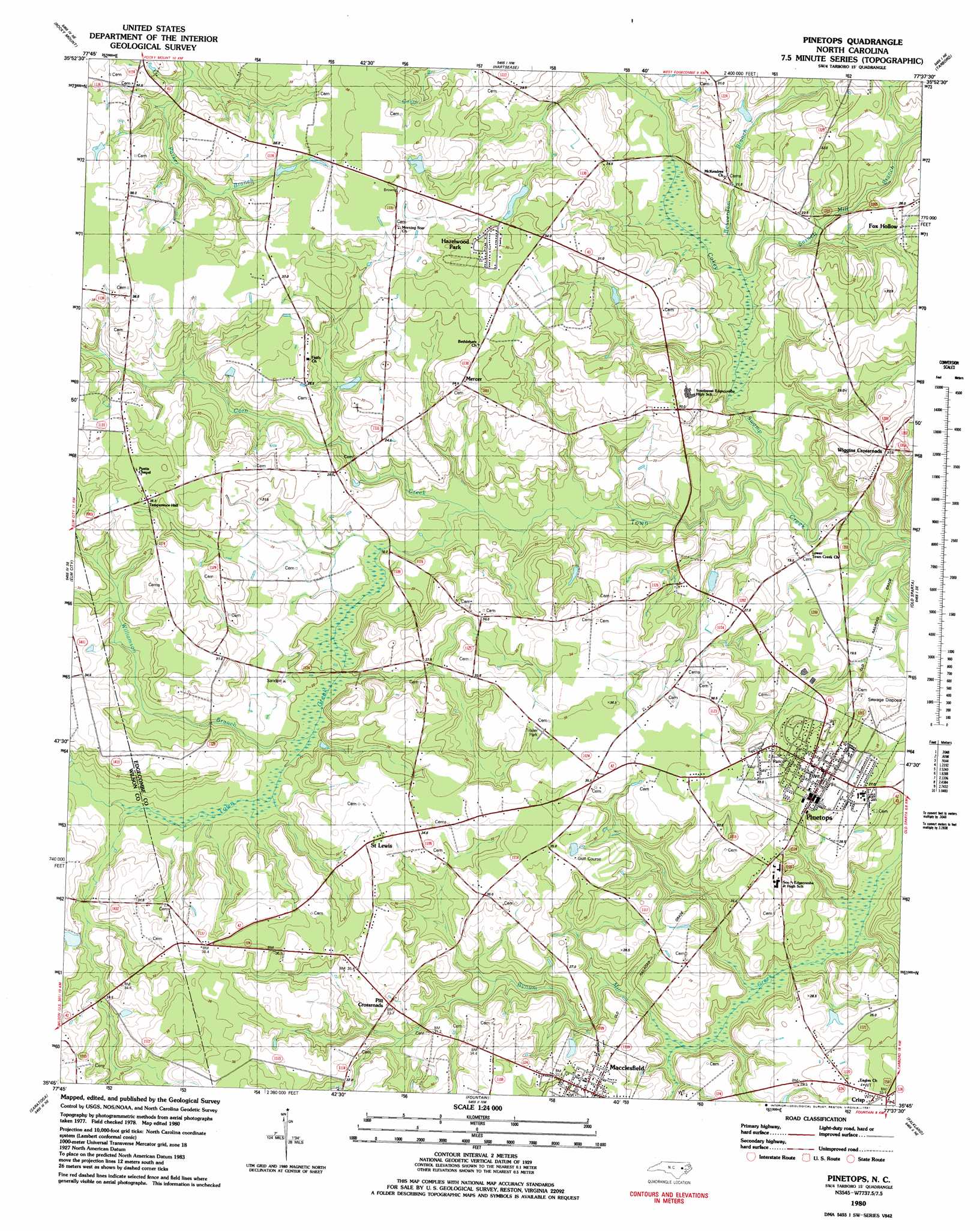
USGS Topo Quad 35077g6 - 1:24,000 scale
| Topo Map Name: | Pinetops |
| USGS Topo Quad ID: | 35077g6 |
| Print Size: | ca. 21 1/4" wide x 27" high |
| Southeast Coordinates: | 35.75° N latitude / 77.625° W longitude |
| Map Center Coordinates: | 35.8125° N latitude / 77.6875° W longitude |
| U.S. State: | NC |
| Filename: | o35077g6.jpg |
| Download Map JPG Image: | Pinetops topo map 1:24,000 scale |
| Map Type: | Topographic |
| Topo Series: | 7.5´ |
| Map Scale: | 1:24,000 |
| Source of Map Images: | United States Geological Survey (USGS) |
| Alternate Map Versions: |
Pinetops NC 1980, updated 1981 Download PDF Buy paper map Pinetops NC 1997, updated 2001 Download PDF Buy paper map Pinetops NC 2010 Download PDF Buy paper map Pinetops NC 2013 Download PDF Buy paper map Pinetops NC 2016 Download PDF Buy paper map |
1:24,000 Topo Quads surrounding Pinetops
Red Oak |
Drake |
Whitakers |
Draughn |
Hobgood |
Nashville |
Rocky Mount |
Hartsease |
Tarboro |
Speed |
Winstead Crossroads |
Elm City |
Pinetops |
Old Sparta |
Conetoe |
Wilson |
Saratoga |
Fountain |
Falkland |
Greenville Nw |
Fremont |
Stantonsburg |
Walstonburg |
Farmville |
Greenville Sw |
> Back to 35077e1 at 1:100,000 scale
> Back to 35076a1 at 1:250,000 scale
> Back to U.S. Topo Maps home
Pinetops topo map: Gazetteer
Pinetops: Dams
NC Noname Eight-Hundred Forty elevation 27m 88′Pinetops: Populated Places
Crisp elevation 32m 104′Fox Hollow elevation 26m 85′
Hazelwood Park elevation 33m 108′
Lancaster elevation 34m 111′
Macclesfield elevation 29m 95′
Mercer elevation 35m 114′
Pinetops elevation 31m 101′
Saint Lewis elevation 35m 114′
Wiggins Crossroads elevation 30m 98′
Pinetops: Reservoirs
Batts Pond elevation 27m 88′Pinetops: Streams
Beaverdam Branch elevation 15m 49′Bynums Mill Run elevation 20m 65′
Cokey Swamp elevation 16m 52′
Corn Creek elevation 16m 52′
Sasnett Mill Branch elevation 17m 55′
Williamson Branch elevation 21m 68′
Pinetops digital topo map on disk
Buy this Pinetops topo map showing relief, roads, GPS coordinates and other geographical features, as a high-resolution digital map file on DVD:
Atlantic Coast (NY, NJ, PA, DE, MD, VA, NC)
Buy digital topo maps: Atlantic Coast (NY, NJ, PA, DE, MD, VA, NC)
 map DVD")