Anderson Creek Topo Map North Carolina
To zoom in, hover over the map of Anderson Creek
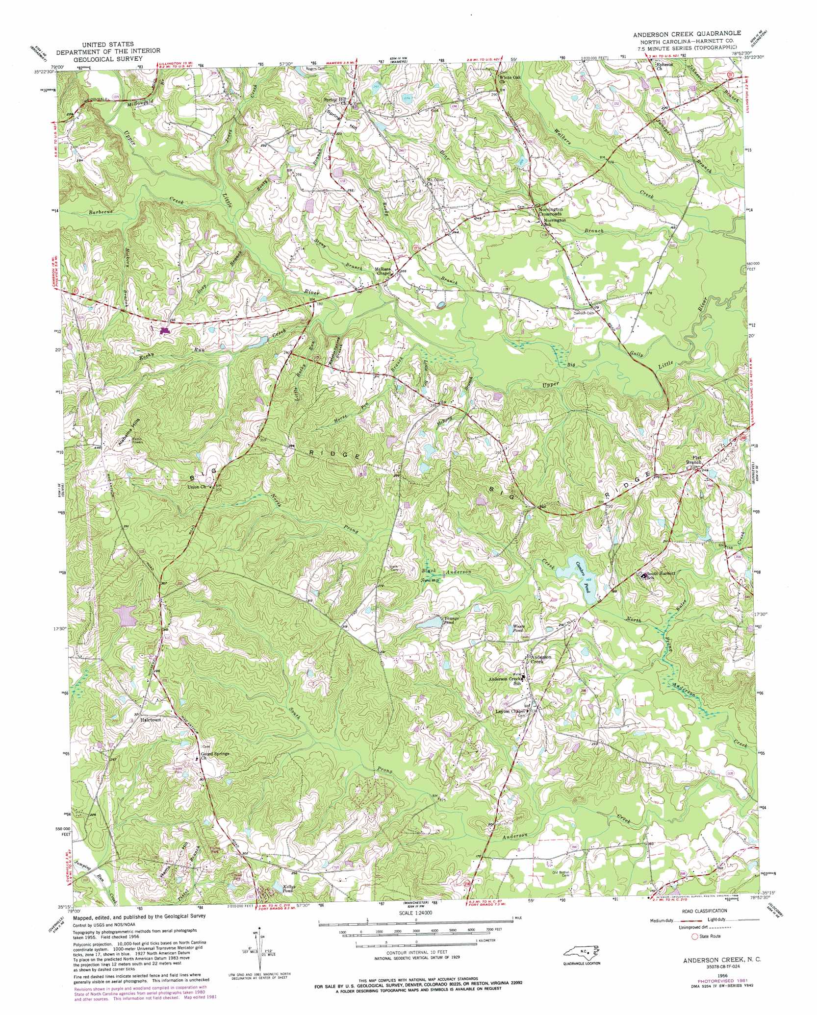
USGS Topo Quad 35078c8 - 1:24,000 scale
| Topo Map Name: | Anderson Creek |
| USGS Topo Quad ID: | 35078c8 |
| Print Size: | ca. 21 1/4" wide x 27" high |
| Southeast Coordinates: | 35.25° N latitude / 78.875° W longitude |
| Map Center Coordinates: | 35.3125° N latitude / 78.9375° W longitude |
| U.S. State: | NC |
| Filename: | o35078c8.jpg |
| Download Map JPG Image: | Anderson Creek topo map 1:24,000 scale |
| Map Type: | Topographic |
| Topo Series: | 7.5´ |
| Map Scale: | 1:24,000 |
| Source of Map Images: | United States Geological Survey (USGS) |
| Alternate Map Versions: |
Anderson Creek NC 1956, updated 1958 Download PDF Buy paper map Anderson Creek NC 1956, updated 1982 Download PDF Buy paper map Anderson Creek NC 1956, updated 1988 Download PDF Buy paper map Anderson Creek NC 2010 Download PDF Buy paper map Anderson Creek NC 2013 Download PDF Buy paper map Anderson Creek NC 2016 Download PDF Buy paper map |
1:24,000 Topo Quads surrounding Anderson Creek
Colon |
Moncure |
Cokesbury |
Fuquay-Varina |
Angier |
Sanford |
Broadway |
Mamers |
Lillington |
Coats |
Murchisontown |
Olivia |
Anderson Creek |
Bunnlevel |
Erwin |
Lobelia |
Overhills |
Manchester |
Slocomb |
Wade |
Nicholson Creek |
Clifdale |
Fayetteville |
Vander |
Stedman |
> Back to 35078a1 at 1:100,000 scale
> Back to 35078a1 at 1:250,000 scale
> Back to U.S. Topo Maps home
Anderson Creek topo map: Gazetteer
Anderson Creek: Dams
Cambro Pond Dam elevation 51m 167′Smith Lake Dam elevation 68m 223′
Anderson Creek: Lakes
Wests Pond elevation 62m 203′Anderson Creek: Populated Places
Anderson Creek elevation 75m 246′Flat Branch elevation 76m 249′
Hairtown elevation 98m 321′
Norrington Crossroads elevation 65m 213′
Anderson Creek: Reservoirs
Cambro Pond elevation 51m 167′Kellys Pond elevation 81m 265′
Smith Lake elevation 68m 223′
Youngs Pond elevation 68m 223′
Anderson Creek: Ridges
Big Ridge elevation 119m 390′Anderson Creek: Streams
Barbecue Creek elevation 55m 180′Bear Branch elevation 46m 150′
Big Gully elevation 48m 157′
Deep Branch elevation 53m 173′
Hickory Branch elevation 57m 187′
Horse Pen Branch elevation 51m 167′
Jones Creek elevation 55m 180′
Knights Spring Branch elevation 54m 177′
Little Branch elevation 52m 170′
Little Rocky Run elevation 55m 180′
McDougald Branch elevation 59m 193′
McRany Branch elevation 51m 167′
North Prong Anderson Creek elevation 41m 134′
Reedy Branch elevation 52m 170′
Rice Patch Branch elevation 57m 187′
Rocky Run Creek elevation 53m 173′
Rooty Branch elevation 55m 180′
South Prong Anderson Creek elevation 41m 134′
South Prong McLeod Creek elevation 66m 216′
Stony Branch elevation 53m 173′
Walkers Creek elevation 46m 150′
Anderson Creek: Summits
Albama Hills elevation 126m 413′Hams Hill elevation 92m 301′
Spring Hill elevation 105m 344′
Anderson Creek: Swamps
Black Swamp elevation 58m 190′Anderson Creek digital topo map on disk
Buy this Anderson Creek topo map showing relief, roads, GPS coordinates and other geographical features, as a high-resolution digital map file on DVD:
South Carolina, Western North Carolina & Northeastern Georgia
Buy digital topo maps: South Carolina, Western North Carolina & Northeastern Georgia