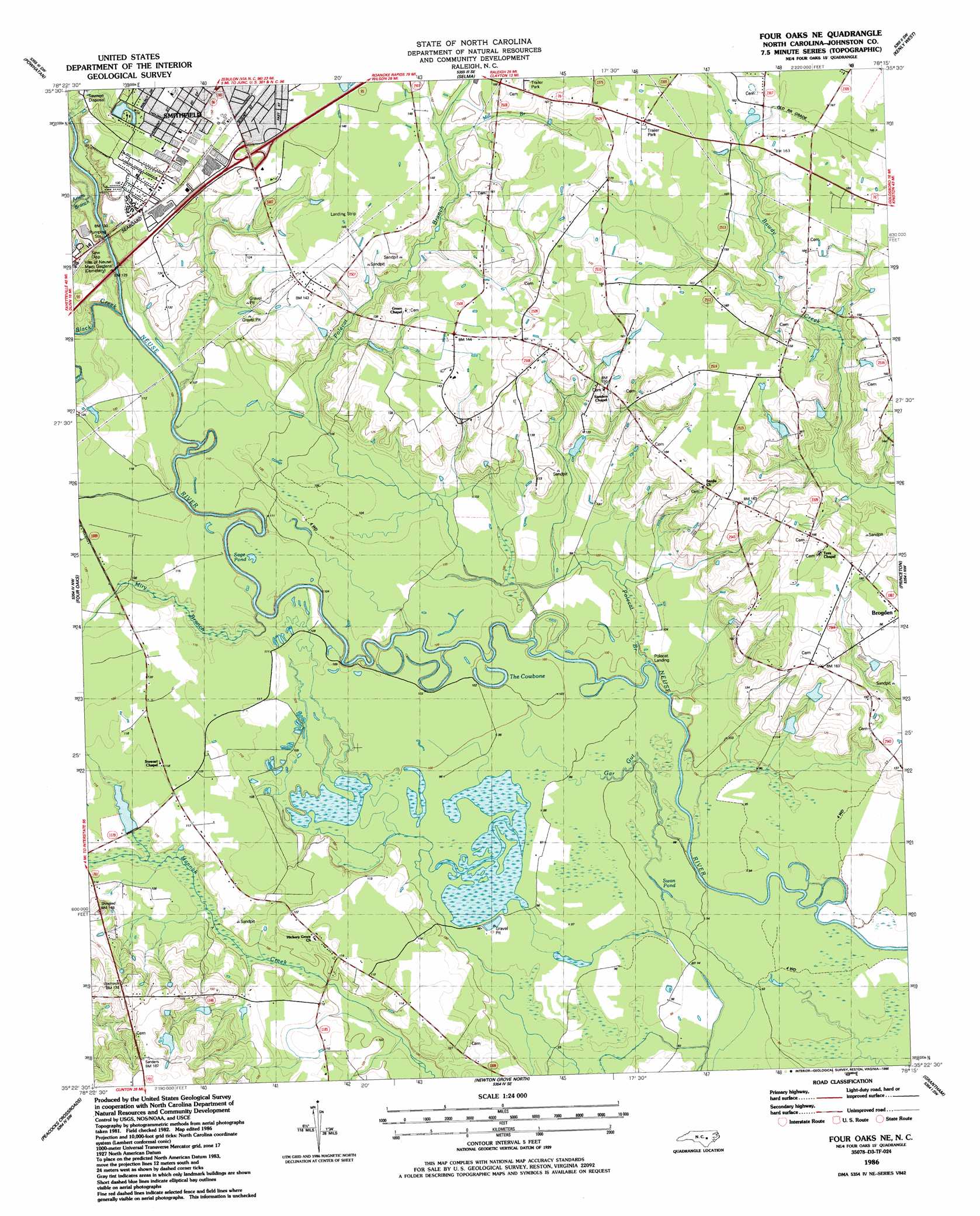
Four Oaks Ne Topo Map North Carolina
To zoom in, hover over the map of Four Oaks Ne
USGS Topo Quad 35078d3 - 1:24,000 scale
| Topo Map Name: | Four Oaks Ne |
| USGS Topo Quad ID: | 35078d3 |
| Print Size: | ca. 21 1/4" wide x 27" high |
| Southeast Coordinates: | 35.375° N latitude / 78.25° W longitude |
| Map Center Coordinates: | 35.4375° N latitude / 78.3125° W longitude |
| U.S. State: | NC |
| Filename: | o35078d3.jpg |
| Download Map JPG Image: | Four Oaks Ne topo map 1:24,000 scale |
| Map Type: | Topographic |
| Topo Series: | 7.5´ |
| Map Scale: | 1:24,000 |
| Source of Map Images: | United States Geological Survey (USGS) |
| Alternate Map Versions: |
Four Oaks NE NC 1986, updated 1986 Download PDF Buy paper map Four Oaks NE NC 1997, updated 2000 Download PDF Buy paper map Four Oaks NE NC 2010 Download PDF Buy paper map Four Oaks NE NC 2013 Download PDF Buy paper map Four Oaks NE NC 2016 Download PDF Buy paper map |
1:24,000 Topo Quads surrounding Four Oaks Ne
Garner |
Clayton |
Flowers |
Stancils Chapel |
Lucama |
Edmondson |
Powhatan |
Selma |
Kenly West |
Kenly East |
Benson |
Four Oaks |
Four Oaks Ne |
Princeton |
Northwest Goldsboro |
Dunn |
Peacocks Crossroads |
Newton Grove North |
Grantham |
Southwest Goldsboro |
Mingo |
Timothy |
Newton Grove South |
Dobbersville |
Mount Olive |
> Back to 35078a1 at 1:100,000 scale
> Back to 35078a1 at 1:250,000 scale
> Back to U.S. Topo Maps home
Four Oaks Ne topo map: Gazetteer
Four Oaks Ne: Bridges
Barefoot Bridge elevation 31m 101′Rhodes Bridge elevation 31m 101′
Sanders Bridge elevation 31m 101′
Four Oaks Ne: Guts
Gar Gut elevation 29m 95′Four Oaks Ne: Lakes
Sage Pond elevation 32m 104′Swan Pond elevation 28m 91′
The Cowbone elevation 29m 95′
Four Oaks Ne: Populated Places
Creeches Mill elevation 49m 160′Oliver elevation 50m 164′
Whitley Place elevation 50m 164′
Four Oaks Ne: Streams
Arters Branch elevation 38m 124′Black Creek elevation 34m 111′
Mill Branch elevation 44m 144′
Miry Branch elevation 34m 111′
Polecat Branch elevation 30m 98′
Four Oaks Ne digital topo map on disk
Buy this Four Oaks Ne topo map showing relief, roads, GPS coordinates and other geographical features, as a high-resolution digital map file on DVD:
South Carolina, Western North Carolina & Northeastern Georgia
Buy digital topo maps: South Carolina, Western North Carolina & Northeastern Georgia