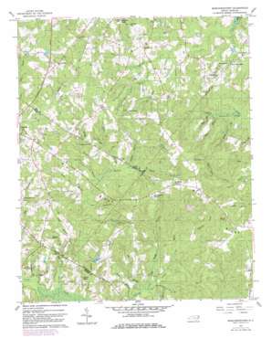
Murchisontown Topo Map North Carolina
To zoom in, hover over the map of Murchisontown
USGS Topo Quad 35079c2 - 1:24,000 scale
| Topo Map Name: | Murchisontown |
| USGS Topo Quad ID: | 35079c2 |
| Print Size: | ca. 21 1/4" wide x 27" high |
| Southeast Coordinates: | 35.25° N latitude / 79.125° W longitude |
| Map Center Coordinates: | 35.3125° N latitude / 79.1875° W longitude |
| U.S. State: | NC |
| Filename: | o35079c2.jpg |
| Download Map JPG Image: | Murchisontown topo map 1:24,000 scale |
| Map Type: | Topographic |
| Topo Series: | 7.5´ |
| Map Scale: | 1:24,000 |
| Source of Map Images: | United States Geological Survey (USGS) |
| Alternate Map Versions: |
Murchisontown NC 1957, updated 1958 Download PDF Buy paper map Murchisontown NC 1957, updated 1982 Download PDF Buy paper map Murchisontown NC 2010 Download PDF Buy paper map Murchisontown NC 2013 Download PDF Buy paper map Murchisontown NC 2016 Download PDF Buy paper map |
1:24,000 Topo Quads surrounding Murchisontown
> Back to 35079a1 at 1:100,000 scale
> Back to 35078a1 at 1:250,000 scale
> Back to U.S. Topo Maps home
Murchisontown topo map: Gazetteer
Murchisontown: Dams
Blue Brothers Pond Dam elevation 95m 311′Murchisontown: Lakes
Duck Pond elevation 127m 416′Huckleberry Pond elevation 126m 413′
Murchisontown: Populated Places
Murchisontown elevation 101m 331′Murchisontown: Reservoirs
Blue Brothers Pond elevation 95m 311′Murchisontown: Streams
Beaver Creek elevation 70m 229′Big Branch elevation 70m 229′
Big Branch elevation 87m 285′
Butler Branch elevation 84m 275′
Deep Branch elevation 68m 223′
Duck Pond Branch elevation 90m 295′
Head Branch elevation 104m 341′
Horse Branch elevation 74m 242′
Long Branch elevation 82m 269′
Long Branch elevation 90m 295′
Long Branch elevation 93m 305′
Lower Run elevation 83m 272′
Mare Branch elevation 92m 301′
McDougald Branch elevation 70m 229′
Middle Prong Cypress Creek elevation 78m 255′
Middle Run elevation 86m 282′
Moore Branch elevation 75m 246′
Old Field Branch elevation 74m 242′
Polly Branch elevation 75m 246′
Reedy Branch elevation 97m 318′
Reedy Branch elevation 71m 232′
Roundabout Branch elevation 75m 246′
Run Branch elevation 98m 321′
Slash Branch elevation 73m 239′
Stony Branch elevation 83m 272′
Succor Branch elevation 96m 314′
Upper Run elevation 88m 288′
Wildcat Branch elevation 90m 295′
Murchisontown: Summits
Round Top elevation 140m 459′Murchisontown: Swamps
MacDonald Swamp elevation 84m 275′Murchisontown digital topo map on disk
Buy this Murchisontown topo map showing relief, roads, GPS coordinates and other geographical features, as a high-resolution digital map file on DVD:
South Carolina, Western North Carolina & Northeastern Georgia
Buy digital topo maps: South Carolina, Western North Carolina & Northeastern Georgia


