Moncure Topo Map North Carolina
To zoom in, hover over the map of Moncure
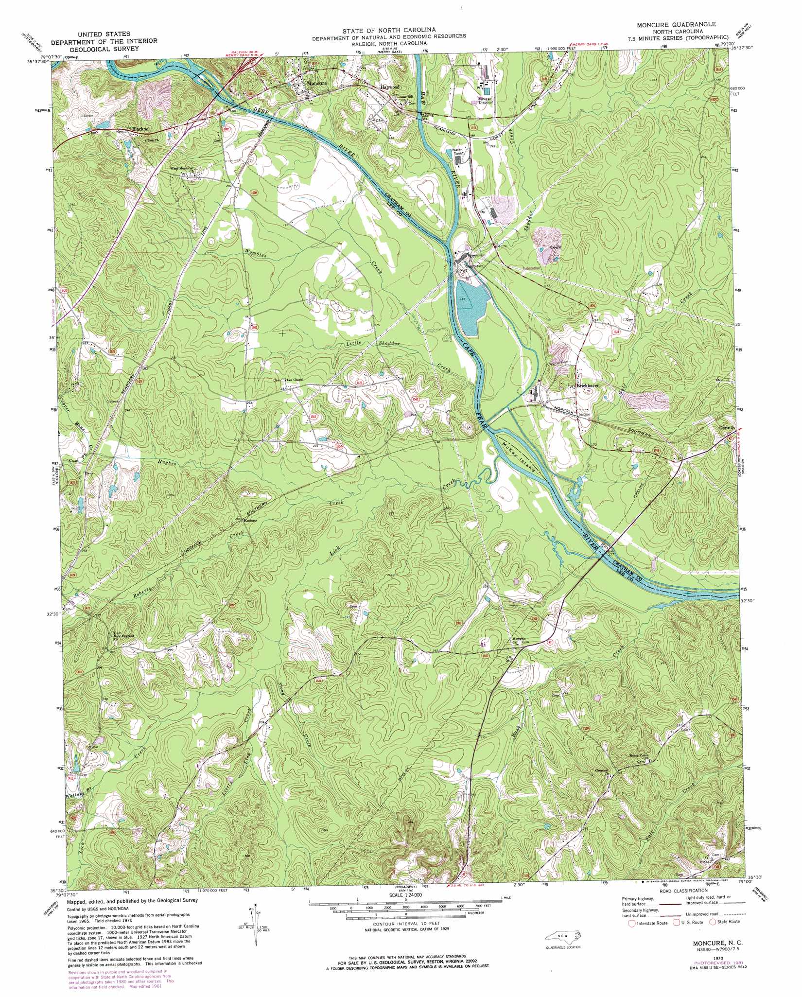
USGS Topo Quad 35079e1 - 1:24,000 scale
| Topo Map Name: | Moncure |
| USGS Topo Quad ID: | 35079e1 |
| Print Size: | ca. 21 1/4" wide x 27" high |
| Southeast Coordinates: | 35.5° N latitude / 79° W longitude |
| Map Center Coordinates: | 35.5625° N latitude / 79.0625° W longitude |
| U.S. State: | NC |
| Filename: | o35079e1.jpg |
| Download Map JPG Image: | Moncure topo map 1:24,000 scale |
| Map Type: | Topographic |
| Topo Series: | 7.5´ |
| Map Scale: | 1:24,000 |
| Source of Map Images: | United States Geological Survey (USGS) |
| Alternate Map Versions: |
Moncure NC 1970, updated 1973 Download PDF Buy paper map Moncure NC 1970, updated 1982 Download PDF Buy paper map Moncure NC 1993, updated 1999 Download PDF Buy paper map Moncure NC 2010 Download PDF Buy paper map Moncure NC 2013 Download PDF Buy paper map Moncure NC 2016 Download PDF Buy paper map |
1:24,000 Topo Quads surrounding Moncure
Silk Hope |
Bynum |
Farrington |
Green Level |
Cary |
Siler City Ne |
Pittsboro |
Merry Oaks |
New Hill |
Apex |
Goldston |
Colon |
Moncure |
Cokesbury |
Fuquay-Varina |
White Hill |
Sanford |
Broadway |
Mamers |
Lillington |
Vass |
Murchisontown |
Olivia |
Anderson Creek |
Bunnlevel |
> Back to 35079e1 at 1:100,000 scale
> Back to 35078a1 at 1:250,000 scale
> Back to U.S. Topo Maps home
Moncure topo map: Gazetteer
Moncure: Dams
Ramsey Millpond Dam elevation 83m 272′Moncure: Islands
McKay Island elevation 50m 164′Moncure: Populated Places
Blacknel elevation 110m 360′Brickhaven elevation 75m 246′
Haywood elevation 75m 246′
Moncure elevation 66m 216′
Rosser elevation 60m 196′
Moncure: Reservoirs
Ramsey Mill Pond elevation 83m 272′Moncure: Streams
Bush Creek elevation 49m 160′Copper Mine Creek elevation 59m 193′
Deep River elevation 49m 160′
Gulf Creek elevation 49m 160′
Gum Fork elevation 59m 193′
Haw River elevation 49m 160′
Hughes Creek elevation 50m 164′
Lick Creek elevation 51m 167′
Little Lick Creek elevation 57m 187′
Little Shaddox Creek elevation 50m 164′
Roberts Creek elevation 52m 170′
Shaddox Creek elevation 50m 164′
Stony Creek elevation 57m 187′
Wallace Branch elevation 65m 213′
Wombles Creek elevation 50m 164′
Moncure digital topo map on disk
Buy this Moncure topo map showing relief, roads, GPS coordinates and other geographical features, as a high-resolution digital map file on DVD:
South Carolina, Western North Carolina & Northeastern Georgia
Buy digital topo maps: South Carolina, Western North Carolina & Northeastern Georgia