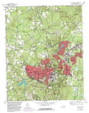
Chapel Hill Topo Map North Carolina
To zoom in, hover over the map of Chapel Hill
USGS Topo Quad 35079h1 - 1:24,000 scale
| Topo Map Name: | Chapel Hill |
| USGS Topo Quad ID: | 35079h1 |
| Print Size: | ca. 21 1/4" wide x 27" high |
| Southeast Coordinates: | 35.875° N latitude / 79° W longitude |
| Map Center Coordinates: | 35.9375° N latitude / 79.0625° W longitude |
| U.S. State: | NC |
| Filename: | o35079h1.jpg |
| Download Map JPG Image: | Chapel Hill topo map 1:24,000 scale |
| Map Type: | Topographic |
| Topo Series: | 7.5´ |
| Map Scale: | 1:24,000 |
| Source of Map Images: | United States Geological Survey (USGS) |
| Alternate Map Versions: |
Chapel Hill NC 1946, updated 1958 Download PDF Buy paper map Chapel Hill NC 1946, updated 1968 Download PDF Buy paper map Chapel Hill NC 1978, updated 1978 Download PDF Buy paper map Chapel Hill NC 1978, updated 1982 Download PDF Buy paper map Chapel Hill NC 1978, updated 1982 Download PDF Buy paper map Chapel Hill NC 1980, updated 1983 Download PDF Buy paper map Chapel Hill NC 1993, updated 1998 Download PDF Buy paper map Chapel Hill NC 2010 Download PDF Buy paper map Chapel Hill NC 2013 Download PDF Buy paper map Chapel Hill NC 2016 Download PDF Buy paper map |
1:24,000 Topo Quads surrounding Chapel Hill
> Back to 35079e1 at 1:100,000 scale
> Back to 35078a1 at 1:250,000 scale
> Back to U.S. Topo Maps home
Chapel Hill topo map: Gazetteer
Chapel Hill: Airports
Hogan Airport elevation 166m 544′Horace Williams Airport elevation 153m 501′
Chapel Hill: Crossings
Interchange 266 elevation 157m 515′Chapel Hill: Dams
Blackwood Lake Dam elevation 138m 452′Eastwood Lake Dam elevation 90m 295′
Lake Hogan Dam elevation 149m 488′
Mountain Creek Lake Dam elevation 171m 561′
University Lake Dam elevation 105m 344′
Chapel Hill: Flats
Meadow Flats elevation 162m 531′Chapel Hill: Lakes
Eastwood Lake elevation 90m 295′Chapel Hill: Parks
Belk Field elevation 132m 433′Boshamer Stadium elevation 128m 419′
Fetzer Field Grandstands elevation 136m 446′
Francis E Henry Stadium elevation 129m 423′
Kenan Stadium elevation 128m 419′
Chapel Hill: Populated Places
Ashley Forest elevation 143m 469′Barrington Hills elevation 163m 534′
Birchwood Lake Estates elevation 148m 485′
Blackwood elevation 147m 482′
Briarcliff elevation 91m 298′
Calvander elevation 167m 547′
Carlton Acres elevation 140m 459′
Carolwoods elevation 156m 511′
Carrboro elevation 141m 462′
Cedar Hill elevation 146m 479′
Chapel Hill elevation 148m 485′
Clark Hills elevation 112m 367′
Coker Hills elevation 123m 403′
Colonial Heights elevation 120m 393′
Colony Park elevation 96m 314′
Colony Woods elevation 89m 291′
Coventry elevation 162m 531′
Davie Circle elevation 143m 469′
Dogwood Acres elevation 131m 429′
Eastowne elevation 94m 308′
Elkins Hills elevation 146m 479′
Estates Hills elevation 114m 374′
Eubanks elevation 145m 475′
Farrington Hills elevation 101m 331′
Fox Meadows elevation 154m 505′
Glen Heights elevation 156m 511′
Glen Lennox elevation 87m 285′
Greenwood elevation 105m 344′
Hidden Hills elevation 91m 298′
High Park elevation 92m 301′
Ironwoods elevation 117m 383′
Kensington Trace elevation 172m 564′
Lake Ellen elevation 131m 429′
Lake Forest Estates elevation 88m 288′
Lakewoods elevation 128m 419′
Laurel Springs elevation 161m 528′
Manor Hill elevation 155m 508′
Morgan Creek Hills elevation 108m 354′
Mount Bolus elevation 137m 449′
North Forest Hills elevation 168m 551′
Northwood elevation 177m 580′
Oak Hills elevation 136m 446′
Pine Knob elevation 135m 442′
Plantation Acres elevation 144m 472′
Quail Run elevation 147m 482′
Rangewood elevation 159m 521′
Ridgefield elevation 82m 269′
Ridgefield Park elevation 75m 246′
Robins Wood elevation 147m 482′
Sedgefield elevation 164m 538′
Southbridge elevation 131m 429′
Spring Valley elevation 149m 488′
Stoneridge elevation 151m 495′
Stoney Brook elevation 129m 423′
Summerfield Crossing elevation 90m 295′
Tenney Circle elevation 136m 446′
The Highlands elevation 144m 472′
The Meadows elevation 91m 298′
The Oaks elevation 86m 282′
The Oaks II elevation 93m 305′
The Woods at Laurel Hill elevation 108m 354′
Timbercrest elevation 116m 380′
Timberlyne elevation 166m 544′
Weatherhill elevation 96m 314′
Wildwood Springs elevation 125m 410′
Chapel Hill: Post Offices
Carrboro Post Office elevation 138m 452′Chapel Hill Post Office elevation 85m 278′
Franklin Street Post Office elevation 146m 479′
Timberlyne Post Office elevation 175m 574′
Chapel Hill: Reservoirs
Blackwoods Lake elevation 138m 452′Hogan Lake elevation 148m 485′
Lake Hogan elevation 149m 488′
Mountain Creek Lake elevation 171m 561′
University Lake elevation 105m 344′
Chapel Hill: Streams
Bolin Creek elevation 76m 249′Booker Creek elevation 76m 249′
Buckhorn Branch elevation 149m 488′
Cedar Fork elevation 91m 298′
Chapel Creek elevation 75m 246′
Church Branch elevation 79m 259′
Crow Branch elevation 129m 423′
East Branch Price Creek elevation 106m 347′
Fan Branch elevation 94m 308′
Garrett Branch elevation 154m 505′
Jolly Branch elevation 133m 436′
Jones Creek elevation 141m 462′
Meeting of the Waters elevation 78m 255′
Mountain Creek elevation 143m 469′
Neville Creek elevation 107m 351′
Old Field Creek elevation 124m 406′
Phils Creek elevation 109m 357′
Pine Mountain Creek elevation 86m 282′
Pritchard Mill Creek elevation 106m 347′
Tanbark Branch elevation 101m 331′
West Branch Price Creek elevation 108m 354′
Wilson Creek elevation 90m 295′
Chapel Hill: Summits
Big Hill elevation 190m 623′Blackwood Mountain elevation 220m 721′
Iron Mine Hill elevation 157m 515′
Laurel Hill elevation 158m 518′
McCauley Mount elevation 186m 610′
Nunn Mountain elevation 189m 620′
Piney Mountain elevation 137m 449′
Stony Hill elevation 182m 597′
Chapel Hill: Valleys
Stillhouse Bottom elevation 91m 298′Chapel Hill digital topo map on disk
Buy this Chapel Hill topo map showing relief, roads, GPS coordinates and other geographical features, as a high-resolution digital map file on DVD:
South Carolina, Western North Carolina & Northeastern Georgia
Buy digital topo maps: South Carolina, Western North Carolina & Northeastern Georgia


