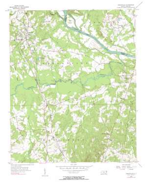
Ansonville Topo Map North Carolina
To zoom in, hover over the map of Ansonville
USGS Topo Quad 35080a1 - 1:24,000 scale
| Topo Map Name: | Ansonville |
| USGS Topo Quad ID: | 35080a1 |
| Print Size: | ca. 21 1/4" wide x 27" high |
| Southeast Coordinates: | 35° N latitude / 80° W longitude |
| Map Center Coordinates: | 35.0625° N latitude / 80.0625° W longitude |
| U.S. State: | NC |
| Filename: | o35080a1.jpg |
| Download Map JPG Image: | Ansonville topo map 1:24,000 scale |
| Map Type: | Topographic |
| Topo Series: | 7.5´ |
| Map Scale: | 1:24,000 |
| Source of Map Images: | United States Geological Survey (USGS) |
| Alternate Map Versions: |
Ansonville NC 1956, updated 1957 Download PDF Buy paper map Ansonville NC 1956, updated 1957 Download PDF Buy paper map Ansonville NC 1956, updated 1990 Download PDF Buy paper map Ansonville NC 2010 Download PDF Buy paper map Ansonville NC 2013 Download PDF Buy paper map Ansonville NC 2016 Download PDF Buy paper map |
1:24,000 Topo Quads surrounding Ansonville
> Back to 35080a1 at 1:100,000 scale
> Back to 35080a1 at 1:250,000 scale
> Back to U.S. Topo Maps home
Ansonville topo map: Gazetteer
Ansonville: Airports
Anson County Airport elevation 90m 295′Wadesboro Airport elevation 92m 301′
Ansonville: Bridges
Bennett Bridge elevation 61m 200′Ansonville: Dams
Gaddys Goose Pond Dam elevation 78m 255′Ansonville: Islands
Buzzard Island elevation 63m 206′Leak Island elevation 63m 206′
Ansonville: Lakes
Andrews Pond elevation 74m 242′Gaddys Goose Ponds elevation 78m 255′
Ingold Pond elevation 80m 262′
Ansonville: Parks
Pee Dee National Wildlife Refuge elevation 68m 223′Ansonville: Populated Places
Ansonville elevation 101m 331′Beverly (historical) elevation 69m 226′
Pinkston elevation 92m 301′
Ansonville: Streams
Brown Creek elevation 55m 180′Buffalo Creek elevation 61m 200′
Cabbage Branch elevation 65m 213′
Canal Branch elevation 65m 213′
Dula Thoroughfare elevation 56m 183′
Flat Fork elevation 57m 187′
Goulds Fork elevation 63m 206′
Grindstone Branch elevation 71m 232′
Hurricane Creek elevation 60m 196′
Permetter Branch elevation 64m 209′
Pressley Creek elevation 56m 183′
Ansonville digital topo map on disk
Buy this Ansonville topo map showing relief, roads, GPS coordinates and other geographical features, as a high-resolution digital map file on DVD:
South Carolina, Western North Carolina & Northeastern Georgia
Buy digital topo maps: South Carolina, Western North Carolina & Northeastern Georgia


