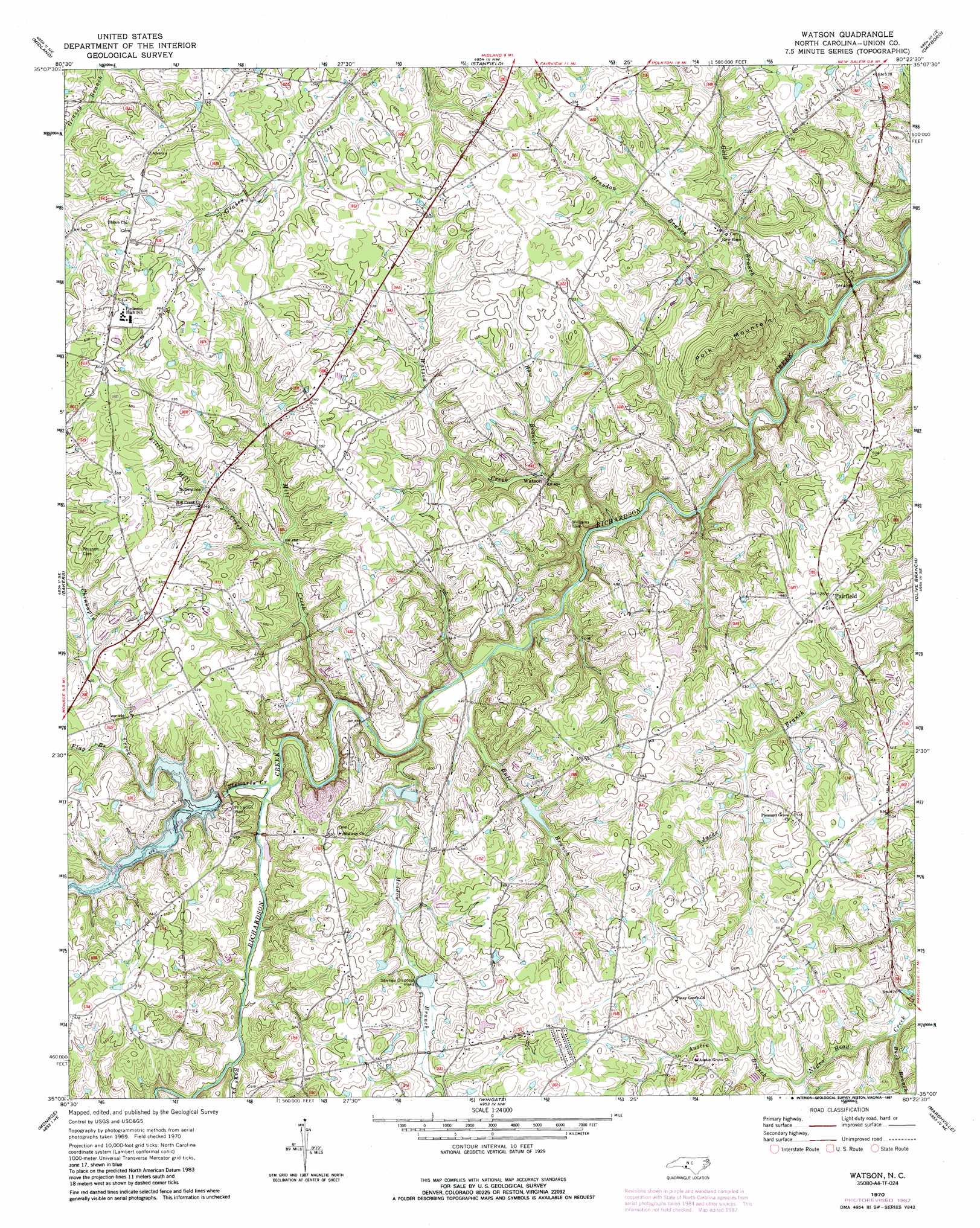
Watson Topo Map North Carolina
To zoom in, hover over the map of Watson
USGS Topo Quad 35080a4 - 1:24,000 scale
| Topo Map Name: | Watson |
| USGS Topo Quad ID: | 35080a4 |
| Print Size: | ca. 21 1/4" wide x 27" high |
| Southeast Coordinates: | 35° N latitude / 80.375° W longitude |
| Map Center Coordinates: | 35.0625° N latitude / 80.4375° W longitude |
| U.S. State: | NC |
| Filename: | o35080a4.jpg |
| Download Map JPG Image: | Watson topo map 1:24,000 scale |
| Map Type: | Topographic |
| Topo Series: | 7.5´ |
| Map Scale: | 1:24,000 |
| Source of Map Images: | United States Geological Survey (USGS) |
| Alternate Map Versions: |
Watson NC 1970, updated 1973 Download PDF Buy paper map Watson NC 1970, updated 1987 Download PDF Buy paper map Watson NC 2010 Download PDF Buy paper map Watson NC 2013 Download PDF Buy paper map Watson NC 2016 Download PDF Buy paper map |
1:24,000 Topo Quads surrounding Watson
Harrisburg |
Concord Se |
Locust |
Frog Pond |
Albemarle |
Mint Hill |
Midland |
Stanfield |
Oakboro |
Aquadale |
Matthews |
Bakers |
Watson |
Olive Branch |
Polkton |
Waxhaw |
Monroe |
Wingate |
Marshville |
Russellville |
Unity |
Tradesville |
Pageland |
Hornsboro |
Mount Croghan |
> Back to 35080a1 at 1:100,000 scale
> Back to 35080a1 at 1:250,000 scale
> Back to U.S. Topo Maps home
Watson topo map: Gazetteer
Watson: Dams
Brewer Lake Dam elevation 137m 449′Twitty Dam elevation 149m 488′
Watson: Populated Places
Fairfield elevation 161m 528′Watson elevation 139m 456′
Watson: Reservoirs
Brewer Lake elevation 137m 449′Lake Twitty elevation 136m 446′
Lake Twitty elevation 149m 488′
Watson: Streams
Austin Branch elevation 146m 479′Brandon Branch elevation 132m 433′
Buck Branch elevation 141m 462′
Bull Branch elevation 128m 419′
Chinkapin Creek elevation 149m 488′
Flag Branch elevation 149m 488′
Gold Branch elevation 116m 380′
Haw Branch elevation 135m 442′
Little Mill Creek elevation 139m 456′
Meadow Branch elevation 131m 429′
Mill Creek elevation 132m 433′
Rays Fork elevation 138m 452′
Spring Branch elevation 153m 501′
Stewarts Creek elevation 133m 436′
Watson Creek elevation 124m 406′
Watson: Summits
Polk Mountain elevation 203m 666′Watson digital topo map on disk
Buy this Watson topo map showing relief, roads, GPS coordinates and other geographical features, as a high-resolution digital map file on DVD:
South Carolina, Western North Carolina & Northeastern Georgia
Buy digital topo maps: South Carolina, Western North Carolina & Northeastern Georgia