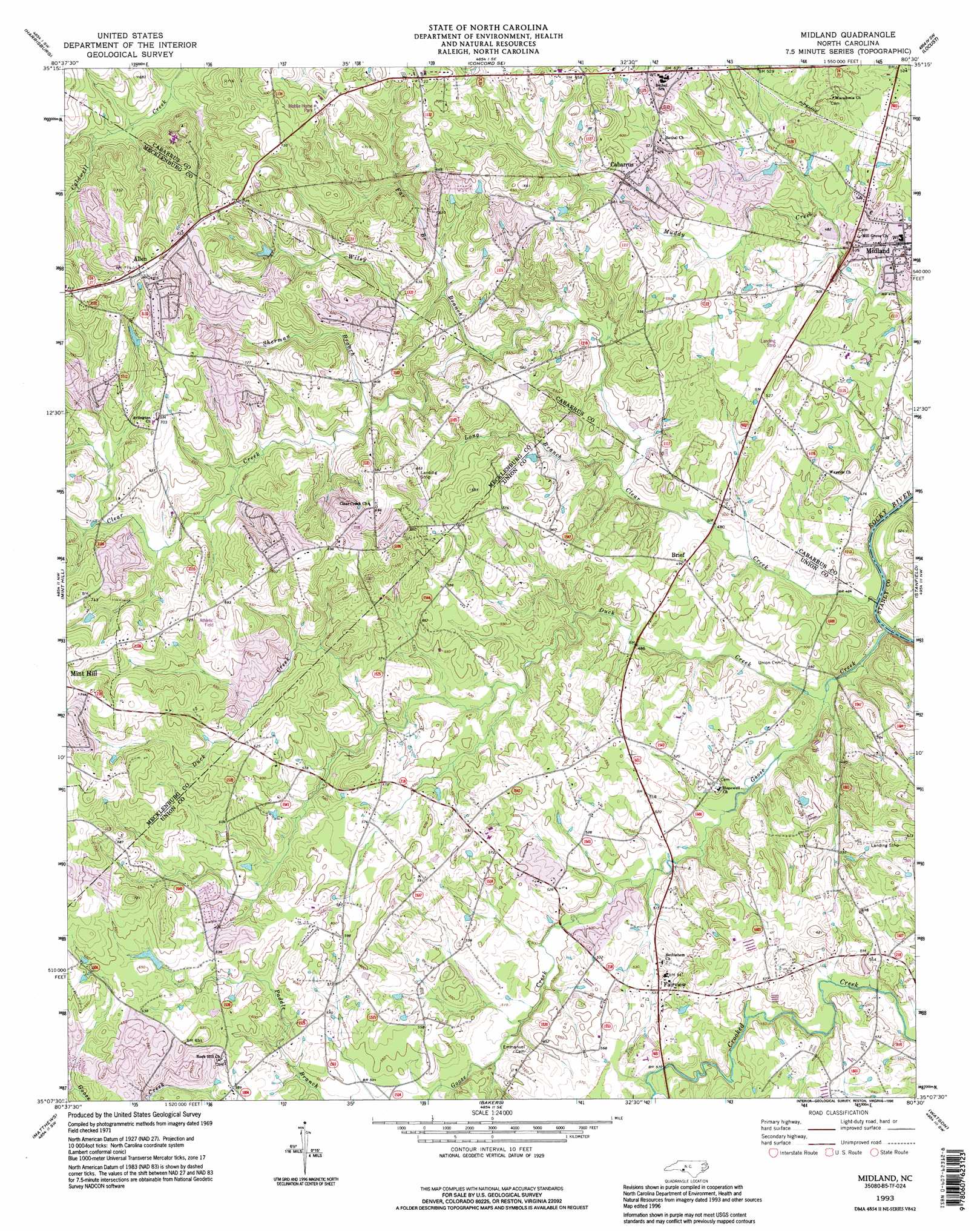
Midland Topo Map North Carolina
To zoom in, hover over the map of Midland
USGS Topo Quad 35080b5 - 1:24,000 scale
| Topo Map Name: | Midland |
| USGS Topo Quad ID: | 35080b5 |
| Print Size: | ca. 21 1/4" wide x 27" high |
| Southeast Coordinates: | 35.125° N latitude / 80.5° W longitude |
| Map Center Coordinates: | 35.1875° N latitude / 80.5625° W longitude |
| U.S. State: | NC |
| Filename: | o35080b5.jpg |
| Download Map JPG Image: | Midland topo map 1:24,000 scale |
| Map Type: | Topographic |
| Topo Series: | 7.5´ |
| Map Scale: | 1:24,000 |
| Source of Map Images: | United States Geological Survey (USGS) |
| Alternate Map Versions: |
Midland NC 1949 Download PDF Buy paper map Midland NC 1971, updated 1973 Download PDF Buy paper map Midland NC 1971, updated 1981 Download PDF Buy paper map Midland NC 1971, updated 1992 Download PDF Buy paper map Midland NC 1993, updated 1996 Download PDF Buy paper map Midland NC 2010 Download PDF Buy paper map Midland NC 2013 Download PDF Buy paper map Midland NC 2016 Download PDF Buy paper map |
1:24,000 Topo Quads surrounding Midland
Cornelius |
Kannapolis |
Concord |
Mount Pleasant |
Richfield |
Derita |
Harrisburg |
Concord Se |
Locust |
Frog Pond |
Charlotte East |
Mint Hill |
Midland |
Stanfield |
Oakboro |
Weddington |
Matthews |
Bakers |
Watson |
Olive Branch |
Catawba Ne |
Waxhaw |
Monroe |
Wingate |
Marshville |
> Back to 35080a1 at 1:100,000 scale
> Back to 35080a1 at 1:250,000 scale
> Back to U.S. Topo Maps home
Midland topo map: Gazetteer
Midland: Dams
Mitchells Lake Dam elevation 199m 652′Midland: Populated Places
Allen elevation 234m 767′Brief elevation 150m 492′
Cabarrus elevation 179m 587′
Clear Creek elevation 183m 600′
Clear Creek (historical) elevation 181m 593′
Fairview elevation 161m 528′
Hornets Nest (historical) elevation 172m 564′
Midland elevation 153m 501′
Midland: Post Offices
Cockburns Post Office elevation 161m 528′Midland: Reservoirs
Mitchells Lake elevation 199m 652′Midland: Streams
Clear Creek elevation 136m 446′Duck Creek elevation 138m 452′
Far Branch elevation 166m 544′
Goose Creek elevation 137m 449′
Long Branch elevation 144m 472′
Sherman Branch elevation 171m 561′
Wiley Branch elevation 161m 528′
Midland digital topo map on disk
Buy this Midland topo map showing relief, roads, GPS coordinates and other geographical features, as a high-resolution digital map file on DVD:
South Carolina, Western North Carolina & Northeastern Georgia
Buy digital topo maps: South Carolina, Western North Carolina & Northeastern Georgia