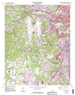
Charlotte West Topo Map North Carolina
To zoom in, hover over the map of Charlotte West
USGS Topo Quad 35080b8 - 1:24,000 scale
| Topo Map Name: | Charlotte West |
| USGS Topo Quad ID: | 35080b8 |
| Print Size: | ca. 21 1/4" wide x 27" high |
| Southeast Coordinates: | 35.125° N latitude / 80.875° W longitude |
| Map Center Coordinates: | 35.1875° N latitude / 80.9375° W longitude |
| U.S. State: | NC |
| Filename: | o35080b8.jpg |
| Download Map JPG Image: | Charlotte West topo map 1:24,000 scale |
| Map Type: | Topographic |
| Topo Series: | 7.5´ |
| Map Scale: | 1:24,000 |
| Source of Map Images: | United States Geological Survey (USGS) |
| Alternate Map Versions: |
Charlotte West NC 1948, updated 1965 Download PDF Buy paper map Charlotte West NC 1949 Download PDF Buy paper map Charlotte West NC 1968, updated 1970 Download PDF Buy paper map Charlotte West NC 1968, updated 1978 Download PDF Buy paper map Charlotte West NC 1968, updated 1981 Download PDF Buy paper map Charlotte West NC 1993, updated 1996 Download PDF Buy paper map Charlotte West NC 2010 Download PDF Buy paper map Charlotte West NC 2013 Download PDF Buy paper map Charlotte West NC 2016 Download PDF Buy paper map |
1:24,000 Topo Quads surrounding Charlotte West
> Back to 35080a1 at 1:100,000 scale
> Back to 35080a1 at 1:250,000 scale
> Back to U.S. Topo Maps home
Charlotte West topo map: Gazetteer
Charlotte West: Airports
Cannon Airport (historical) elevation 236m 774′Charlotte Police Dept Airport elevation 202m 662′
Charlotte/Douglas International Airport elevation 216m 708′
Morris Field (historical) elevation 199m 652′
Charlotte West: Dams
American Legion Lake Dam elevation 199m 652′Danga Lake Dam elevation 197m 646′
Eagle Lake Dam elevation 193m 633′
Johnston Lake Dam elevation 185m 606′
Moore Lake Dam elevation 211m 692′
Waddell Lake Dam elevation 185m 606′
Whippoorwill Lake Dam elevation 193m 633′
Charlotte West: Parks
Amay James Park elevation 200m 656′Dowd House Historic Site elevation 229m 751′
Enderly Park elevation 214m 702′
Revolution Park elevation 192m 629′
York Road Community Park elevation 195m 639′
Charlotte West: Populated Places
Ashley Park elevation 234m 767′Berryhill elevation 217m 711′
British Woods elevation 204m 669′
Catawba Colony elevation 193m 633′
Clayton Park elevation 192m 629′
Colony Acres elevation 202m 662′
Dalton Village elevation 206m 675′
Dixie elevation 226m 741′
Elliot Acres elevation 199m 652′
Enderly Park elevation 226m 741′
Greenbriar Woods elevation 208m 682′
Greycrest elevation 198m 649′
Hebron elevation 199m 652′
Huntlynn Acres elevation 184m 603′
Lebanon Heights elevation 205m 672′
Montclaire South elevation 192m 629′
Olde Whitehall elevation 186m 610′
Olympic Woods elevation 222m 728′
Parkwood elevation 212m 695′
Pinecrest elevation 222m 728′
Ramblewood elevation 183m 600′
Shopton elevation 221m 725′
Southbourne elevation 197m 646′
Springfield elevation 200m 656′
Steelberry Acres elevation 210m 688′
Steele Creek elevation 184m 603′
Taragate Farms elevation 192m 629′
Twelve Oaks elevation 193m 633′
Westerly Hill elevation 221m 725′
Westmoreland elevation 218m 715′
White Hall (historical) elevation 204m 669′
Windsong Trails elevation 192m 629′
Yorkmont elevation 218m 715′
Yorkmount Park elevation 205m 672′
Yorkwood elevation 187m 613′
Charlotte West: Reservoirs
American Legion Lake elevation 199m 652′Danga Lake elevation 197m 646′
Eagle Lake elevation 193m 633′
Greenwood Lake elevation 185m 606′
Johnson Lake elevation 187m 613′
Johnston Lake elevation 185m 606′
Legion Lake elevation 200m 656′
Maynard Lake elevation 185m 606′
Moody Lake elevation 187m 613′
Moore Lake elevation 211m 692′
Shoaf Lake elevation 204m 669′
Spratt Lake elevation 182m 597′
Waddell Lake elevation 185m 606′
Watt Lake elevation 205m 672′
Whippoorwill Lake elevation 193m 633′
Charlotte West: Streams
Coffey Creek elevation 171m 561′Irwin Creek elevation 182m 597′
Taggart Creek elevation 182m 597′
Ticer Branch elevation 174m 570′
Charlotte West digital topo map on disk
Buy this Charlotte West topo map showing relief, roads, GPS coordinates and other geographical features, as a high-resolution digital map file on DVD:
South Carolina, Western North Carolina & Northeastern Georgia
Buy digital topo maps: South Carolina, Western North Carolina & Northeastern Georgia


