Morrow Mountain Topo Map North Carolina
To zoom in, hover over the map of Morrow Mountain
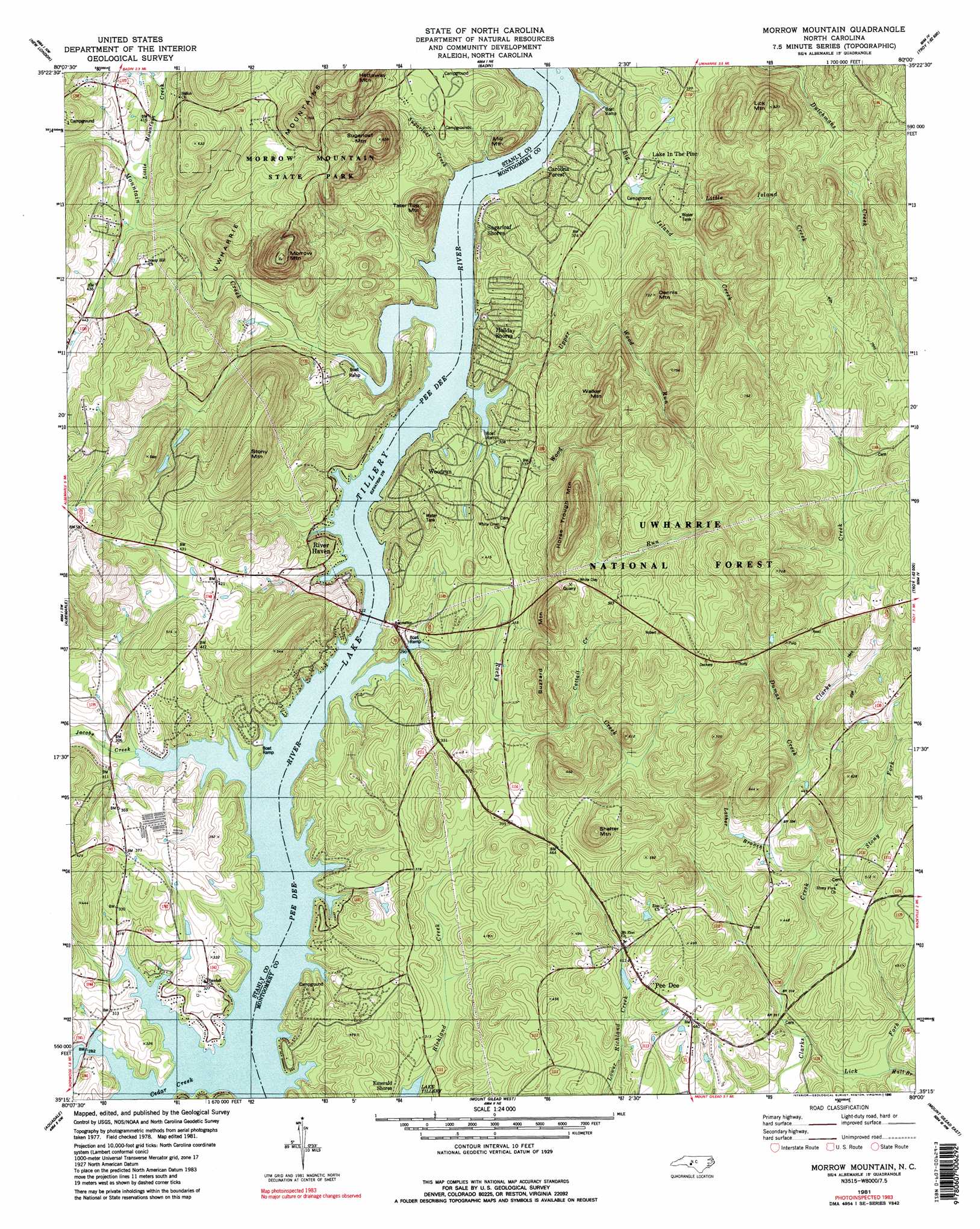
USGS Topo Quad 35080c1 - 1:24,000 scale
| Topo Map Name: | Morrow Mountain |
| USGS Topo Quad ID: | 35080c1 |
| Print Size: | ca. 21 1/4" wide x 27" high |
| Southeast Coordinates: | 35.25° N latitude / 80° W longitude |
| Map Center Coordinates: | 35.3125° N latitude / 80.0625° W longitude |
| U.S. State: | NC |
| Filename: | o35080c1.jpg |
| Download Map JPG Image: | Morrow Mountain topo map 1:24,000 scale |
| Map Type: | Topographic |
| Topo Series: | 7.5´ |
| Map Scale: | 1:24,000 |
| Source of Map Images: | United States Geological Survey (USGS) |
| Alternate Map Versions: |
Albemarle SE NC 1977, updated 1979 Download PDF Buy paper map Morrow Mountain NC 1981, updated 1981 Download PDF Buy paper map Morrow Mountain NC 1981, updated 1990 Download PDF Buy paper map Morrow Mountain NC 1981, updated 1990 Download PDF Buy paper map Morrow Mountain NC 1994, updated 1996 Download PDF Buy paper map Morrow Mountain NC 2011 Download PDF Buy paper map Morrow Mountain NC 2013 Download PDF Buy paper map Morrow Mountain NC 2016 Download PDF Buy paper map |
| FStopo: | US Forest Service topo Morrow Mountain is available: Download FStopo PDF Download FStopo TIF |
1:24,000 Topo Quads surrounding Morrow Mountain
Gold Hill |
High Rock |
Handy |
Eleazer |
Seagrove |
Richfield |
New London |
Badin |
Lovejoy |
Star |
Frog Pond |
Albemarle |
Morrow Mountain |
Troy |
Biscoe |
Oakboro |
Aquadale |
Mount Gilead West |
Mount Gilead East |
Harrisville |
Olive Branch |
Polkton |
Ansonville |
Mangum |
Ellerbe |
> Back to 35080a1 at 1:100,000 scale
> Back to 35080a1 at 1:250,000 scale
> Back to U.S. Topo Maps home
Morrow Mountain topo map: Gazetteer
Morrow Mountain: Dams
Stony Mountain Number One Dam elevation 108m 354′Stony Mountain Number Two Dam elevation 113m 370′
Morrow Mountain: Populated Places
Carolina Forest elevation 92m 301′Emerald Shores elevation 99m 324′
Holiday Shores elevation 107m 351′
Lake in the Pine elevation 111m 364′
Pee Dee elevation 119m 390′
River Haven elevation 91m 298′
Sugarloaf Shores elevation 89m 291′
Woodrun elevation 117m 383′
Morrow Mountain: Reservoirs
Stony Mountain Lake Number One elevation 108m 354′Stony Mountain Lake Number Two elevation 113m 370′
Morrow Mountain: Streams
Big Island Creek elevation 84m 275′Cattail Creek elevation 124m 406′
Cedar Creek elevation 83m 272′
Dumas Creek elevation 130m 426′
Hall Branch elevation 101m 331′
Jacobs Creek elevation 83m 272′
Lather Branch elevation 114m 374′
Lick Fork elevation 90m 295′
Little Island Creek elevation 99m 324′
Little Mountain Creek elevation 116m 380′
Mountain Creek elevation 84m 275′
Rocky Creek elevation 84m 275′
Stony Fork elevation 109m 357′
Sugarloaf Creek elevation 84m 275′
Upper Wood Run elevation 85m 278′
Wood Run elevation 84m 275′
Morrow Mountain: Summits
Buzzard Mountain elevation 217m 711′Dennis Mountain elevation 218m 715′
Hattaway Mountain elevation 255m 836′
Horse Trough Mountain elevation 236m 774′
Lick Mountain elevation 249m 816′
Mill Mountain elevation 162m 531′
Morrow Mountain elevation 276m 905′
Shelter Mountain elevation 216m 708′
Stony Mountain elevation 221m 725′
Sugarloaf Mountain elevation 257m 843′
Tater Top Mountain elevation 198m 649′
Walker Mountain elevation 224m 734′
Morrow Mountain: Trails
Uwharrie National Recreation Trail elevation 127m 416′Morrow Mountain digital topo map on disk
Buy this Morrow Mountain topo map showing relief, roads, GPS coordinates and other geographical features, as a high-resolution digital map file on DVD:
South Carolina, Western North Carolina & Northeastern Georgia
Buy digital topo maps: South Carolina, Western North Carolina & Northeastern Georgia