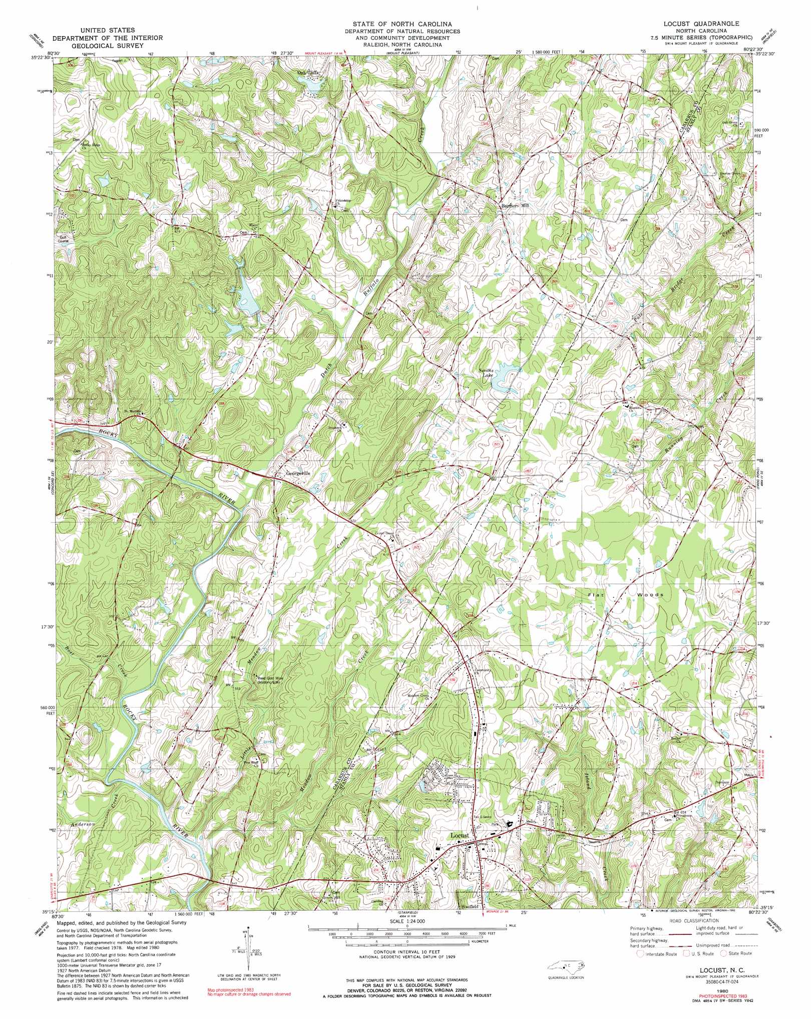
Locust Topo Map North Carolina
To zoom in, hover over the map of Locust
USGS Topo Quad 35080c4 - 1:24,000 scale
| Topo Map Name: | Locust |
| USGS Topo Quad ID: | 35080c4 |
| Print Size: | ca. 21 1/4" wide x 27" high |
| Southeast Coordinates: | 35.25° N latitude / 80.375° W longitude |
| Map Center Coordinates: | 35.3125° N latitude / 80.4375° W longitude |
| U.S. State: | NC |
| Filename: | o35080c4.jpg |
| Download Map JPG Image: | Locust topo map 1:24,000 scale |
| Map Type: | Topographic |
| Topo Series: | 7.5´ |
| Map Scale: | 1:24,000 |
| Source of Map Images: | United States Geological Survey (USGS) |
| Alternate Map Versions: |
Locust NC 1980, updated 1981 Download PDF Buy paper map Locust NC 1980, updated 1992 Download PDF Buy paper map Locust NC 2010 Download PDF Buy paper map Locust NC 2013 Download PDF Buy paper map Locust NC 2016 Download PDF Buy paper map |
1:24,000 Topo Quads surrounding Locust
Enochville |
China Grove |
Rockwell |
Gold Hill |
High Rock |
Kannapolis |
Concord |
Mount Pleasant |
Richfield |
New London |
Harrisburg |
Concord Se |
Locust |
Frog Pond |
Albemarle |
Mint Hill |
Midland |
Stanfield |
Oakboro |
Aquadale |
Matthews |
Bakers |
Watson |
Olive Branch |
Polkton |
> Back to 35080a1 at 1:100,000 scale
> Back to 35080a1 at 1:250,000 scale
> Back to U.S. Topo Maps home
Locust topo map: Gazetteer
Locust: Dams
Furr Lake Dam elevation 175m 574′Oak Cliff Lake Dam elevation 170m 557′
Pharrs Lake Dam elevation 155m 508′
Smiths Lake Dam elevation 198m 649′
Locust: Lakes
Smiths Lake elevation 198m 649′Locust: Mines
Reed Gold Mine (historical) elevation 173m 567′Locust: Populated Places
Barriers Mill elevation 176m 577′Bosts Mill (historical) elevation 148m 485′
Furrs (historical) elevation 154m 505′
Garmons (historical) elevation 170m 557′
Georgeville elevation 161m 528′
Locust elevation 221m 725′
Oak Cliffs elevation 181m 593′
Locust: Reservoirs
Furr Lake elevation 175m 574′Oak Cliff Lake elevation 170m 557′
Pharrs Lake elevation 155m 508′
Locust: Streams
Anderson Creek elevation 147m 482′Bost Creek elevation 143m 469′
Dutch Buffalo Creek elevation 150m 492′
Little Meadow Creek elevation 142m 465′
Meadow Creek elevation 141m 462′
Locust: Woods
Flat Woods elevation 202m 662′Locust digital topo map on disk
Buy this Locust topo map showing relief, roads, GPS coordinates and other geographical features, as a high-resolution digital map file on DVD:
South Carolina, Western North Carolina & Northeastern Georgia
Buy digital topo maps: South Carolina, Western North Carolina & Northeastern Georgia