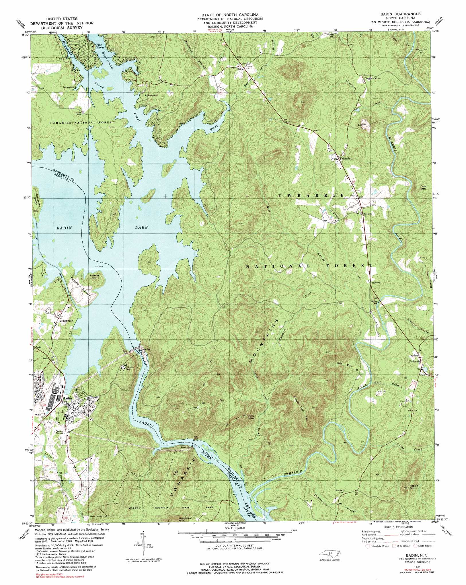
Badin Topo Map North Carolina
To zoom in, hover over the map of Badin
USGS Topo Quad 35080d1 - 1:24,000 scale
| Topo Map Name: | Badin |
| USGS Topo Quad ID: | 35080d1 |
| Print Size: | ca. 21 1/4" wide x 27" high |
| Southeast Coordinates: | 35.375° N latitude / 80° W longitude |
| Map Center Coordinates: | 35.4375° N latitude / 80.0625° W longitude |
| U.S. State: | NC |
| Filename: | o35080d1.jpg |
| Download Map JPG Image: | Badin topo map 1:24,000 scale |
| Map Type: | Topographic |
| Topo Series: | 7.5´ |
| Map Scale: | 1:24,000 |
| Source of Map Images: | United States Geological Survey (USGS) |
| Alternate Map Versions: |
Albemarle NE NC 1977, updated 1979 Download PDF Buy paper map Badin NC 1981, updated 1981 Download PDF Buy paper map Badin NC 1981, updated 1991 Download PDF Buy paper map Badin NC 1994, updated 1996 Download PDF Buy paper map Badin NC 1994, updated 1998 Download PDF Buy paper map Badin NC 2011 Download PDF Buy paper map Badin NC 2013 Download PDF Buy paper map Badin NC 2016 Download PDF Buy paper map |
| FStopo: | US Forest Service topo Badin is available: Download FStopo PDF Download FStopo TIF |
1:24,000 Topo Quads surrounding Badin
Southmont |
Denton Nw |
Denton |
Farmer |
Asheboro |
Gold Hill |
High Rock |
Handy |
Eleazer |
Seagrove |
Richfield |
New London |
Badin |
Lovejoy |
Star |
Frog Pond |
Albemarle |
Morrow Mountain |
Troy |
Biscoe |
Oakboro |
Aquadale |
Mount Gilead West |
Mount Gilead East |
Harrisville |
> Back to 35080a1 at 1:100,000 scale
> Back to 35080a1 at 1:250,000 scale
> Back to U.S. Topo Maps home
Badin topo map: Gazetteer
Badin: Channels
Narrows of the Yadkin elevation 198m 649′Badin: Dams
Badin Dam elevation 141m 462′Falls Dam elevation 99m 324′
Narrous Dam elevation 154m 505′
Yadkin Falls Dam elevation 89m 291′
Badin: Islands
Graveyard Island elevation 168m 551′Palmer Island elevation 173m 567′
Badin: Parks
Morrow Mountain State Park elevation 136m 446′Uwharrie Wildlife Area elevation 242m 793′
Badin: Populated Places
Badin elevation 157m 515′Blaine elevation 178m 583′
Coggins Mine elevation 150m 492′
Eldorado elevation 158m 518′
Palmerville elevation 184m 603′
Pine Haven elevation 159m 521′
Uwharrie elevation 138m 452′
Badin: Ranges
Uwharrie Mountains elevation 242m 793′Badin: Reservoirs
Badin Lake elevation 133m 436′Falls Reservoir elevation 89m 291′
Badin: Streams
Barnes Creek elevation 95m 311′Cedar Creek elevation 88m 288′
Crow Creek elevation 127m 416′
Duncombe Creek elevation 102m 334′
Dutch John Creek elevation 84m 275′
Dutchmans Creek elevation 87m 285′
Glady Fork elevation 154m 505′
Gold Mine Branch elevation 90m 295′
Hall Branch elevation 91m 298′
Horsepen Creek elevation 106m 347′
McLeans Creek elevation 105m 344′
Moccasin Creek elevation 95m 311′
Mountain Branch elevation 160m 524′
Reeves Spring Branch elevation 154m 505′
Reynolds Creek elevation 155m 508′
Spencer Creek elevation 94m 308′
Uwharrie River elevation 83m 272′
Watery Branch elevation 127m 416′
West Branch Moccasin Creek elevation 105m 344′
Yadkin River elevation 84m 275′
Badin: Summits
Cole Mountain elevation 161m 528′Fall Mountain elevation 221m 725′
Falls Mountain elevation 243m 797′
Palmer Mountain elevation 205m 672′
Rabbit Mountain elevation 225m 738′
Shingle Trap Mountain elevation 249m 816′
Badin digital topo map on disk
Buy this Badin topo map showing relief, roads, GPS coordinates and other geographical features, as a high-resolution digital map file on DVD:
South Carolina, Western North Carolina & Northeastern Georgia
Buy digital topo maps: South Carolina, Western North Carolina & Northeastern Georgia