Lake Norman South Topo Map North Carolina
To zoom in, hover over the map of Lake Norman South
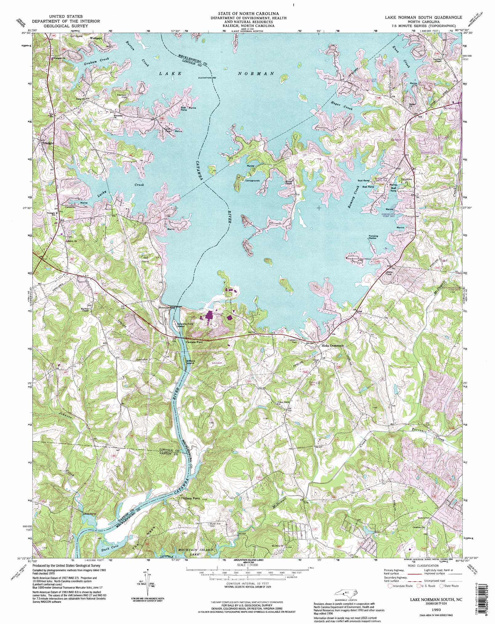
USGS Topo Quad 35080d8 - 1:24,000 scale
| Topo Map Name: | Lake Norman South |
| USGS Topo Quad ID: | 35080d8 |
| Print Size: | ca. 21 1/4" wide x 27" high |
| Southeast Coordinates: | 35.375° N latitude / 80.875° W longitude |
| Map Center Coordinates: | 35.4375° N latitude / 80.9375° W longitude |
| U.S. State: | NC |
| Filename: | o35080d8.jpg |
| Download Map JPG Image: | Lake Norman South topo map 1:24,000 scale |
| Map Type: | Topographic |
| Topo Series: | 7.5´ |
| Map Scale: | 1:24,000 |
| Source of Map Images: | United States Geological Survey (USGS) |
| Alternate Map Versions: |
Hicks Crossroads NC 1949 Download PDF Buy paper map Lake Norman South NC 1970, updated 1972 Download PDF Buy paper map Lake Norman South NC 1970, updated 1972 Download PDF Buy paper map Lake Norman South NC 1993, updated 1996 Download PDF Buy paper map Lake Norman South NC 2011 Download PDF Buy paper map Lake Norman South NC 2013 Download PDF Buy paper map Lake Norman South NC 2016 Download PDF Buy paper map |
1:24,000 Topo Quads surrounding Lake Norman South
Newton |
Catawba |
Troutman |
Shepherds |
Cleveland |
Maiden |
Denver |
Lake Norman North |
Mooresville |
Enochville |
Lincolnton East |
Lowesville |
Lake Norman South |
Cornelius |
Kannapolis |
Gastonia North |
Mount Holly |
Mountain Island Lake |
Derita |
Harrisburg |
Gastonia South |
Belmont |
Charlotte West |
Charlotte East |
Mint Hill |
> Back to 35080a1 at 1:100,000 scale
> Back to 35080a1 at 1:250,000 scale
> Back to U.S. Topo Maps home
Lake Norman South topo map: Gazetteer
Lake Norman South: Bays
Duck Cove elevation 196m 643′Lake Norman South: Capes
The Neck elevation 237m 777′Lake Norman South: Dams
Cowans Ford Dam elevation 197m 646′Lake Norman South: Islands
Beatty Ford Islands (historical) elevation 230m 754′Cowans Ford Island elevation 198m 649′
Graham Island (historical) elevation 230m 754′
Sifford Island elevation 196m 643′
Lake Norman South: Lakes
Hasting Lake elevation 215m 705′Kelly Lake elevation 217m 711′
Nixon Lake elevation 240m 787′
Smith Lake elevation 243m 797′
Stillwell Lake elevation 239m 784′
Lake Norman South: Parks
Auten Nature Preserve elevation 228m 748′Beatty Ford Access Area elevation 231m 757′
Black Trailer Park elevation 246m 807′
Cowans Ford Wildlife Refuge elevation 228m 748′
General Davidson Memorial Historic Site elevation 243m 797′
Ramsey Creek County Park elevation 235m 770′
Stephens Road Nature Preserve elevation 202m 662′
Lake Norman South: Populated Places
Allison Ferry elevation 208m 682′Cowans Ford elevation 196m 643′
Hicks Crossroads elevation 243m 797′
Lake Norman South: Reservoirs
Lake Norman elevation 230m 754′Lake Norman South: Streams
Burton Creek elevation 231m 757′Caldwell Station Creek elevation 211m 692′
Graham Creek elevation 231m 757′
Hager Creek elevation 231m 757′
Johnson Creek elevation 197m 646′
Knox Creek elevation 231m 757′
Lucky Creek elevation 231m 757′
Ramsey Creek elevation 231m 757′
Torrence Creek elevation 206m 675′
Lake Norman South digital topo map on disk
Buy this Lake Norman South topo map showing relief, roads, GPS coordinates and other geographical features, as a high-resolution digital map file on DVD:
South Carolina, Western North Carolina & Northeastern Georgia
Buy digital topo maps: South Carolina, Western North Carolina & Northeastern Georgia