Lake Norman North Topo Map North Carolina
To zoom in, hover over the map of Lake Norman North
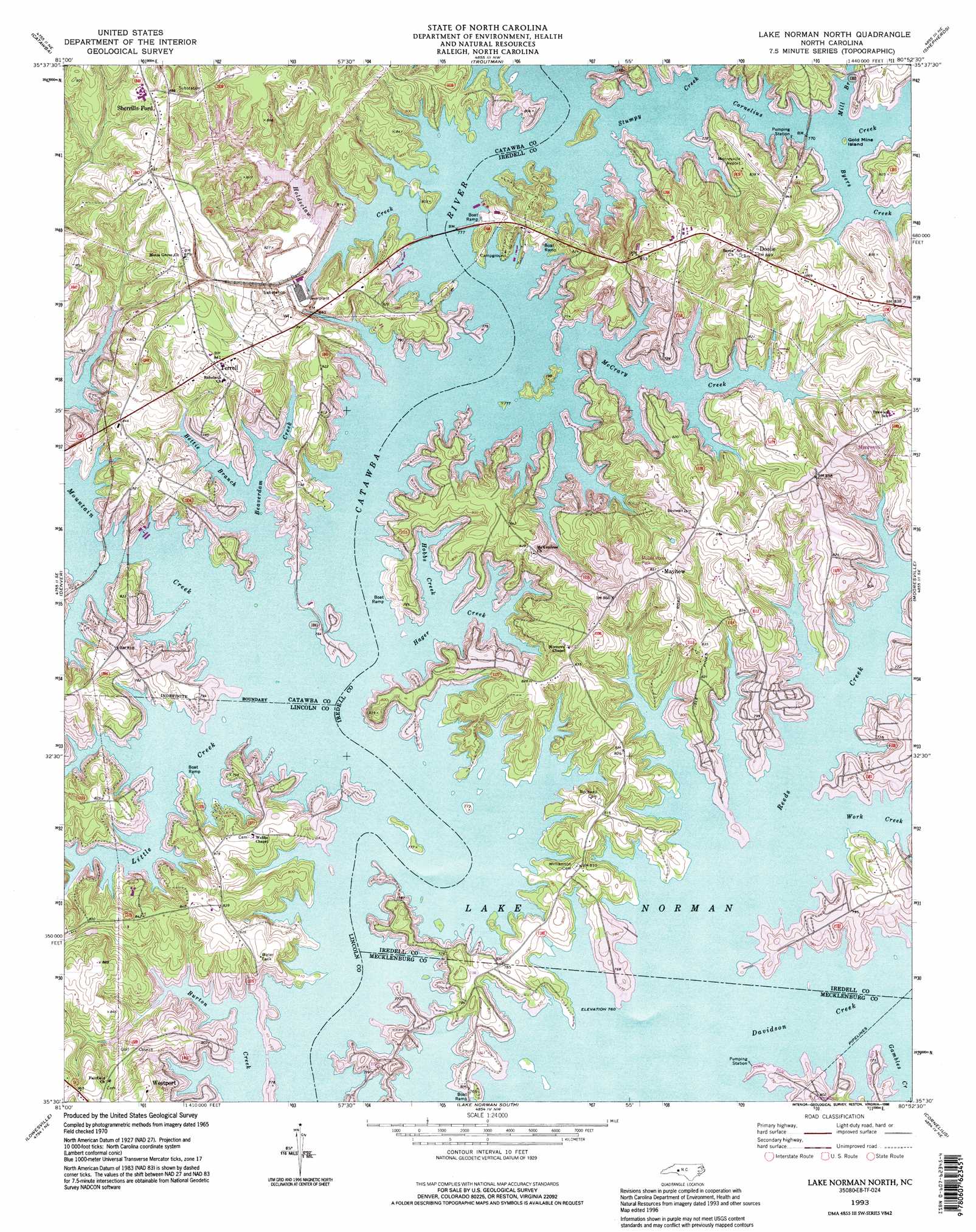
USGS Topo Quad 35080e8 - 1:24,000 scale
| Topo Map Name: | Lake Norman North |
| USGS Topo Quad ID: | 35080e8 |
| Print Size: | ca. 21 1/4" wide x 27" high |
| Southeast Coordinates: | 35.5° N latitude / 80.875° W longitude |
| Map Center Coordinates: | 35.5625° N latitude / 80.9375° W longitude |
| U.S. State: | NC |
| Filename: | o35080e8.jpg |
| Download Map JPG Image: | Lake Norman North topo map 1:24,000 scale |
| Map Type: | Topographic |
| Topo Series: | 7.5´ |
| Map Scale: | 1:24,000 |
| Source of Map Images: | United States Geological Survey (USGS) |
| Alternate Map Versions: |
Lake Norman North NC 1970, updated 1972 Download PDF Buy paper map Lake Norman North NC 1970, updated 1977 Download PDF Buy paper map Lake Norman North NC 1970, updated 1992 Download PDF Buy paper map Lake Norman North NC 1993, updated 1996 Download PDF Buy paper map Lake Norman North NC 2011 Download PDF Buy paper map Lake Norman North NC 2013 Download PDF Buy paper map Lake Norman North NC 2016 Download PDF Buy paper map |
1:24,000 Topo Quads surrounding Lake Norman North
Millersville |
Stony Point |
Statesville West |
Statesville East |
Cool Springs |
Newton |
Catawba |
Troutman |
Shepherds |
Cleveland |
Maiden |
Denver |
Lake Norman North |
Mooresville |
Enochville |
Lincolnton East |
Lowesville |
Lake Norman South |
Cornelius |
Kannapolis |
Gastonia North |
Mount Holly |
Mountain Island Lake |
Derita |
Harrisburg |
> Back to 35080e1 at 1:100,000 scale
> Back to 35080a1 at 1:250,000 scale
> Back to U.S. Topo Maps home
Lake Norman North topo map: Gazetteer
Lake Norman North: Airports
Lake Norman Airport elevation 250m 820′Lake Norman North: Areas
Little Creek Access Area elevation 235m 770′Lake Norman North: Dams
Auto Storage Dam Number One elevation 243m 797′Auto Storage Dam Number Two elevation 239m 784′
Lake Norman North: Islands
Gold Mine Island elevation 233m 764′Lake Norman North: Parks
Hager Creek Access Area elevation 232m 761′McCrary Access Area elevation 231m 757′
Pinnacle Access Area elevation 236m 774′
Lake Norman North: Populated Places
Doolie elevation 265m 869′Lake Norman of Catawba elevation 248m 813′
Mayhew elevation 261m 856′
River View (historical) elevation 236m 774′
Sherrills Ford elevation 273m 895′
Terrell elevation 259m 849′
Webbs elevation 247m 810′
Westport elevation 239m 784′
Lake Norman North: Reservoirs
Auto Storage Lake Number One elevation 243m 797′Auto Storage Lake Number Two elevation 239m 784′
Lake Norman North: Streams
Beaverdam Creek elevation 231m 757′Bettie Branch elevation 231m 757′
Byers Creek elevation 231m 757′
Cornelius Creek elevation 231m 757′
Davidson Creek elevation 231m 757′
Gambles Creek elevation 231m 757′
Hager Creek elevation 231m 757′
Hobbs Creek elevation 231m 757′
Holdsclaw Creek elevation 231m 757′
Little Creek elevation 231m 757′
McCrary Creek elevation 231m 757′
Mill Branch elevation 231m 757′
Mountain Creek elevation 231m 757′
Reeds Creek elevation 231m 757′
Stumpy Creek elevation 231m 757′
Work Creek elevation 231m 757′
Lake Norman North digital topo map on disk
Buy this Lake Norman North topo map showing relief, roads, GPS coordinates and other geographical features, as a high-resolution digital map file on DVD:
South Carolina, Western North Carolina & Northeastern Georgia
Buy digital topo maps: South Carolina, Western North Carolina & Northeastern Georgia