Salisbury Topo Map North Carolina
To zoom in, hover over the map of Salisbury
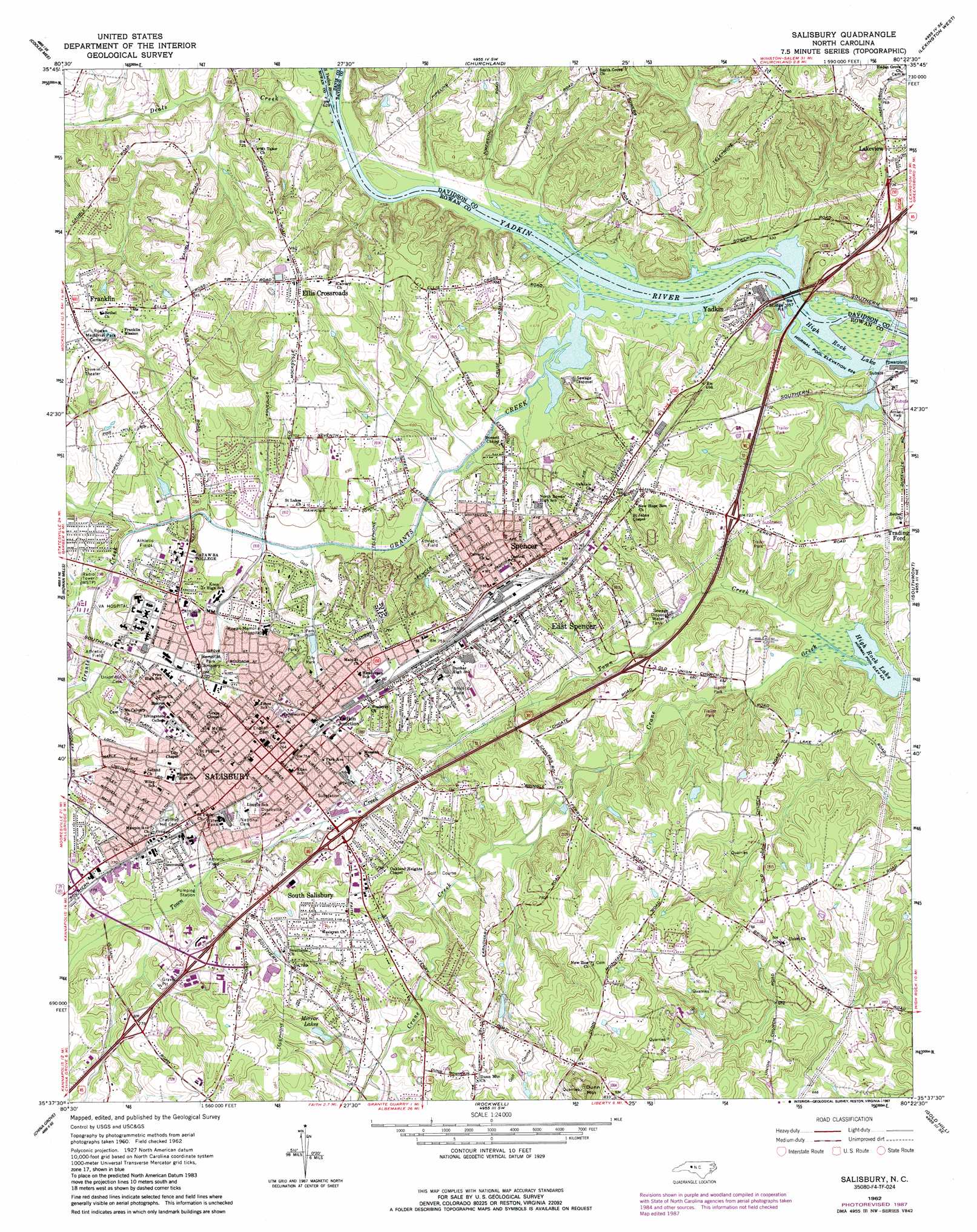
USGS Topo Quad 35080f4 - 1:24,000 scale
| Topo Map Name: | Salisbury |
| USGS Topo Quad ID: | 35080f4 |
| Print Size: | ca. 21 1/4" wide x 27" high |
| Southeast Coordinates: | 35.625° N latitude / 80.375° W longitude |
| Map Center Coordinates: | 35.6875° N latitude / 80.4375° W longitude |
| U.S. State: | NC |
| Filename: | o35080f4.jpg |
| Download Map JPG Image: | Salisbury topo map 1:24,000 scale |
| Map Type: | Topographic |
| Topo Series: | 7.5´ |
| Map Scale: | 1:24,000 |
| Source of Map Images: | United States Geological Survey (USGS) |
| Alternate Map Versions: |
Salisbury NC 1962, updated 1964 Download PDF Buy paper map Salisbury NC 1962, updated 1977 Download PDF Buy paper map Salisbury NC 1962, updated 1987 Download PDF Buy paper map Salisbury NC 1977, updated 1980 Download PDF Buy paper map Salisbury NC 2010 Download PDF Buy paper map Salisbury NC 2013 Download PDF Buy paper map Salisbury NC 2016 Download PDF Buy paper map |
1:24,000 Topo Quads surrounding Salisbury
Calahaln |
Mocksville |
Advance |
Welcome |
Midway |
Cool Springs |
Cooleemee |
Churchland |
Lexington West |
Lexington East |
Cleveland |
Rowan Mills |
Salisbury |
Southmont |
Denton Nw |
Enochville |
China Grove |
Rockwell |
Gold Hill |
High Rock |
Kannapolis |
Concord |
Mount Pleasant |
Richfield |
New London |
> Back to 35080e1 at 1:100,000 scale
> Back to 35080a1 at 1:250,000 scale
> Back to U.S. Topo Maps home
Salisbury topo map: Gazetteer
Salisbury: Bridges
Beards Bridge elevation 190m 623′Looks Bridge (historical) elevation 190m 623′
Salisbury: Crossings
Brown Ferry (historical) elevation 190m 623′Salisbury: Dams
Messinger Dam elevation 208m 682′Salisbury: Lakes
Mirror Lakes elevation 222m 728′Salisbury: Parks
Cannon Park elevation 224m 734′Coleman Recreational Center elevation 214m 702′
Confederate Prison Site elevation 232m 761′
Doctor Josephus Hall House elevation 238m 780′
Ellis Park elevation 236m 774′
Forest Hill Park elevation 207m 679′
Grimes Mill elevation 224m 734′
Historical Mint Park elevation 231m 757′
Jersey City Park elevation 227m 744′
Lincoln Park elevation 228m 748′
Long Street Park elevation 223m 731′
Mahaley Park elevation 215m 705′
Miller Park elevation 222m 728′
Morlan Park elevation 225m 738′
Oakland Heights Park elevation 217m 711′
Old Lutheran Cemetery elevation 228m 748′
Presbyterian Lecture Room elevation 237m 777′
Southern Railway Park elevation 225m 738′
Spencer Park elevation 211m 692′
YMCA elevation 227m 744′
Salisbury: Populated Places
Bellemeade elevation 204m 669′Belmont elevation 217m 711′
Brentwood Acres elevation 223m 731′
Catawba Heights elevation 210m 688′
Cedarcrest elevation 227m 744′
Corbin Hills elevation 219m 718′
Country Club Hills elevation 205m 672′
Cross Heights elevation 221m 725′
Dogwood Acres elevation 237m 777′
Eagle Heights elevation 197m 646′
Eaman Park elevation 215m 705′
East Spencer elevation 218m 715′
Eastbronk elevation 246m 807′
Eastwood Village elevation 217m 711′
Ellis Crossroads elevation 235m 770′
Fairview elevation 224m 734′
Forest Hills elevation 217m 711′
Franklin elevation 240m 787′
Fulton Heights elevation 229m 751′
Grady Heights elevation 209m 685′
Jefferson Heights elevation 231m 757′
Ludwick Acres elevation 222m 728′
McCall Heights elevation 219m 718′
Meadowbrook elevation 212m 695′
Mirror Park elevation 230m 754′
Mocksville elevation 239m 784′
Morlan Park elevation 226m 741′
Moyle Heights elevation 216m 708′
Newton Heights elevation 221m 725′
Oak Ridge elevation 235m 770′
Oakland elevation 223m 731′
Oakland Park elevation 229m 751′
Park View Heights elevation 211m 692′
Ridgewood elevation 216m 708′
Rowan Terrace elevation 230m 754′
Salisbury elevation 234m 767′
Sandy Ridge Terrace elevation 244m 800′
Sedgefield Acres elevation 223m 731′
Shannon Park elevation 220m 721′
Smith (historical) elevation 213m 698′
South Salisbury elevation 232m 761′
Spencer elevation 216m 708′
Steel (historical) elevation 227m 744′
Steel Worth Park elevation 221m 725′
Sunrise Acres elevation 215m 705′
Union Terrace elevation 215m 705′
Whiteheads Mill (historical) elevation 194m 636′
Woodbine elevation 225m 738′
Yadkin elevation 214m 702′
Yadkin Junction elevation 226m 741′
Salisbury: Post Offices
Salisbury Post Office elevation 236m 774′Salisbury: Reservoirs
Messinger Lake elevation 208m 682′Salisbury: Streams
Deals Creek elevation 190m 623′Grants Creek elevation 190m 623′
Jump and Run Branch elevation 198m 649′
South Yadkin River elevation 192m 629′
Town Creek elevation 189m 620′
Salisbury: Summits
Dunn Mountain elevation 306m 1003′Salisbury digital topo map on disk
Buy this Salisbury topo map showing relief, roads, GPS coordinates and other geographical features, as a high-resolution digital map file on DVD:
South Carolina, Western North Carolina & Northeastern Georgia
Buy digital topo maps: South Carolina, Western North Carolina & Northeastern Georgia