Rowan Mills Topo Map North Carolina
To zoom in, hover over the map of Rowan Mills
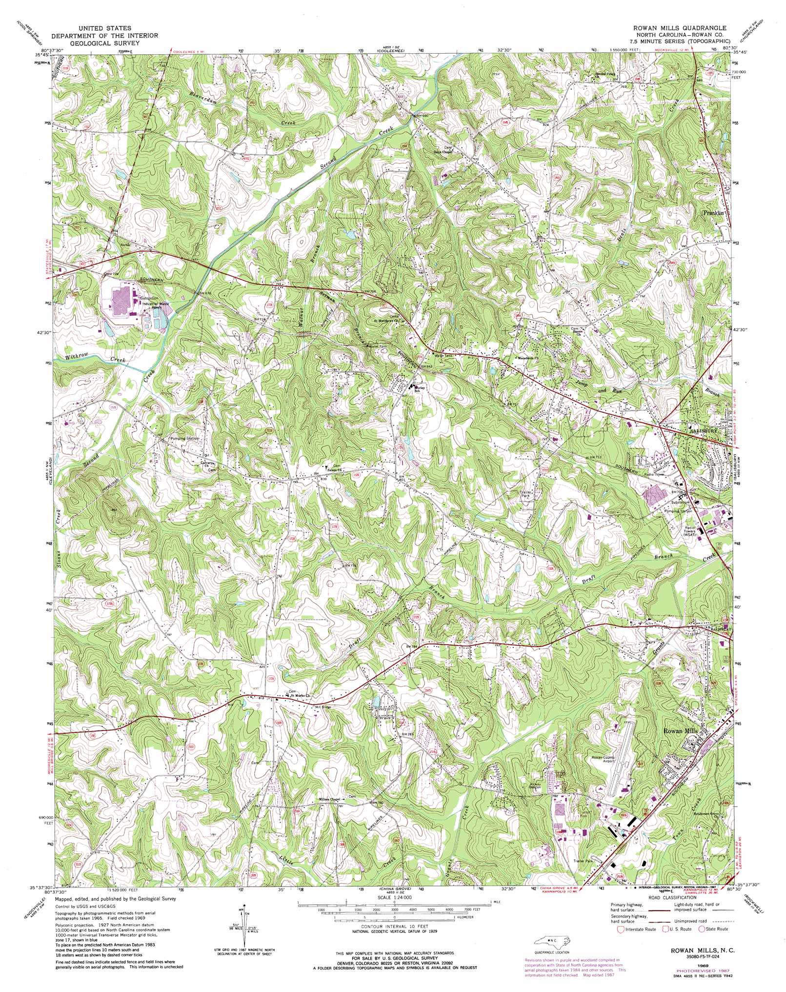
USGS Topo Quad 35080f5 - 1:24,000 scale
| Topo Map Name: | Rowan Mills |
| USGS Topo Quad ID: | 35080f5 |
| Print Size: | ca. 21 1/4" wide x 27" high |
| Southeast Coordinates: | 35.625° N latitude / 80.5° W longitude |
| Map Center Coordinates: | 35.6875° N latitude / 80.5625° W longitude |
| U.S. State: | NC |
| Filename: | o35080f5.jpg |
| Download Map JPG Image: | Rowan Mills topo map 1:24,000 scale |
| Map Type: | Topographic |
| Topo Series: | 7.5´ |
| Map Scale: | 1:24,000 |
| Source of Map Images: | United States Geological Survey (USGS) |
| Alternate Map Versions: |
Rowan Mills NC 1969, updated 1972 Download PDF Buy paper map Rowan Mills NC 1969, updated 1987 Download PDF Buy paper map Rowan Mills NC 2010 Download PDF Buy paper map Rowan Mills NC 2013 Download PDF Buy paper map Rowan Mills NC 2016 Download PDF Buy paper map |
1:24,000 Topo Quads surrounding Rowan Mills
Harmony |
Calahaln |
Mocksville |
Advance |
Welcome |
Statesville East |
Cool Springs |
Cooleemee |
Churchland |
Lexington West |
Shepherds |
Cleveland |
Rowan Mills |
Salisbury |
Southmont |
Mooresville |
Enochville |
China Grove |
Rockwell |
Gold Hill |
Cornelius |
Kannapolis |
Concord |
Mount Pleasant |
Richfield |
> Back to 35080e1 at 1:100,000 scale
> Back to 35080a1 at 1:250,000 scale
> Back to U.S. Topo Maps home
Rowan Mills topo map: Gazetteer
Rowan Mills: Airports
Rowan County Airport elevation 235m 770′Rowan Mills: Dams
Fiber Lake Dam elevation 208m 682′Rowan County Wildlife Lake Dam elevation 240m 787′
Rowan Mills: Populated Places
Dobbins (historical) elevation 224m 734′Frohock Mill (historical) elevation 202m 662′
Hendrick Estates elevation 240m 787′
Holly Park elevation 230m 754′
Lincoln Heights elevation 219m 718′
Lockeland elevation 203m 666′
Milford Hills elevation 216m 708′
Milford Knoll elevation 223m 731′
Milford Terrace elevation 226m 741′
Overbrook Acres elevation 207m 679′
Red Acres elevation 227m 744′
Rolling Hills elevation 237m 777′
Rowan Mills elevation 227m 744′
Sunrise Park elevation 224m 734′
Watson Village elevation 241m 790′
Westcliff elevation 244m 800′
Woodbridge Run elevation 227m 744′
Rowan Mills: Reservoirs
Fiber Lake elevation 208m 682′Rowan County Wildlife Lake elevation 240m 787′
Rowan Mills: Streams
Beaverdam Creek elevation 196m 643′Draft Branch elevation 201m 659′
Little Creek elevation 208m 682′
Setman Branch elevation 204m 669′
Walnut Branch elevation 198m 649′
Withrow Creek elevation 199m 652′
Rowan Mills digital topo map on disk
Buy this Rowan Mills topo map showing relief, roads, GPS coordinates and other geographical features, as a high-resolution digital map file on DVD:
South Carolina, Western North Carolina & Northeastern Georgia
Buy digital topo maps: South Carolina, Western North Carolina & Northeastern Georgia