Troutman Topo Map North Carolina
To zoom in, hover over the map of Troutman
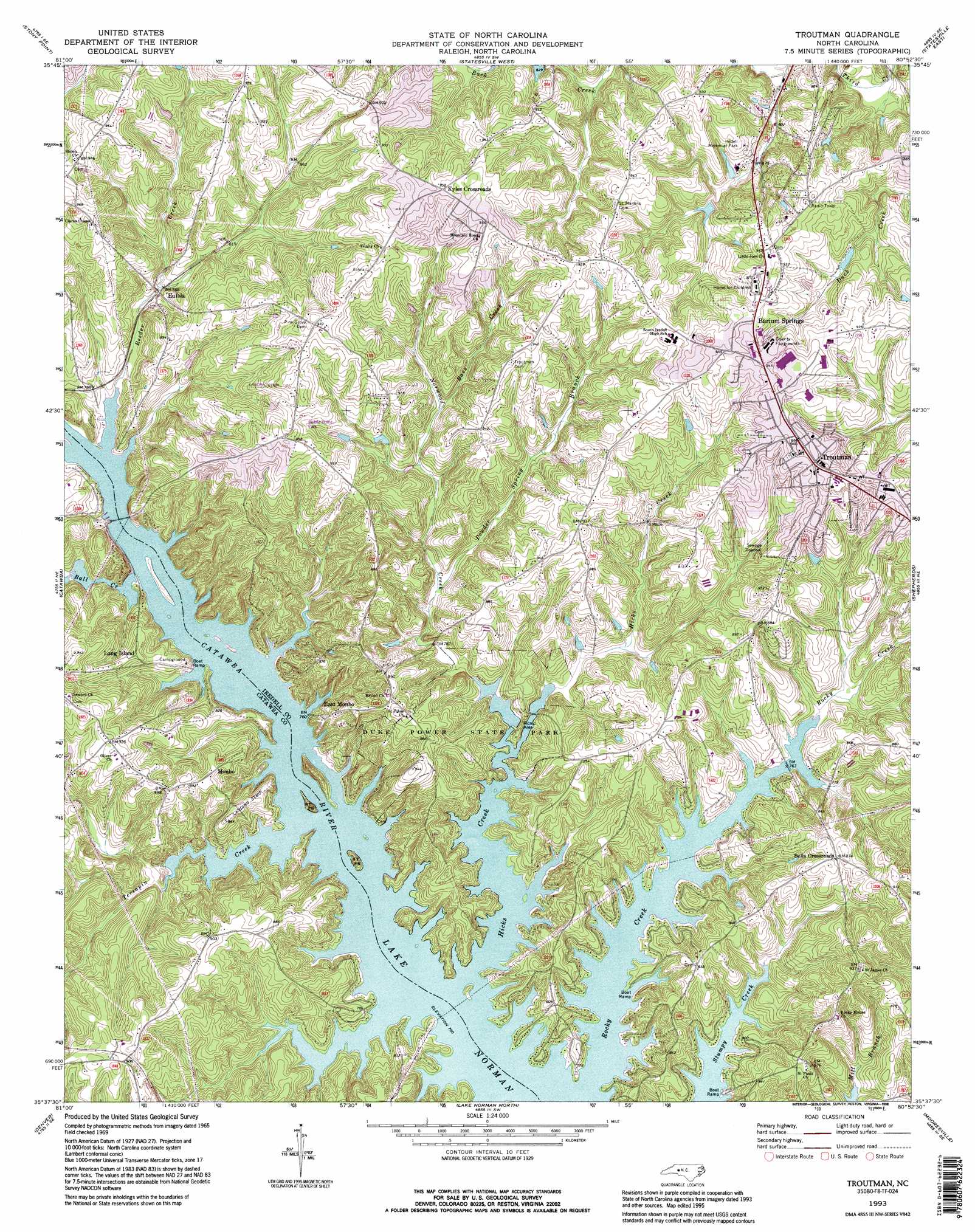
USGS Topo Quad 35080f8 - 1:24,000 scale
| Topo Map Name: | Troutman |
| USGS Topo Quad ID: | 35080f8 |
| Print Size: | ca. 21 1/4" wide x 27" high |
| Southeast Coordinates: | 35.625° N latitude / 80.875° W longitude |
| Map Center Coordinates: | 35.6875° N latitude / 80.9375° W longitude |
| U.S. State: | NC |
| Filename: | o35080f8.jpg |
| Download Map JPG Image: | Troutman topo map 1:24,000 scale |
| Map Type: | Topographic |
| Topo Series: | 7.5´ |
| Map Scale: | 1:24,000 |
| Source of Map Images: | United States Geological Survey (USGS) |
| Alternate Map Versions: |
Troutman NC 1969, updated 1972 Download PDF Buy paper map Troutman NC 1993, updated 1996 Download PDF Buy paper map Troutman NC 2010 Download PDF Buy paper map Troutman NC 2013 Download PDF Buy paper map Troutman NC 2016 Download PDF Buy paper map |
1:24,000 Topo Quads surrounding Troutman
Taylorsville |
Hiddenite |
Central |
Harmony |
Calahaln |
Millersville |
Stony Point |
Statesville West |
Statesville East |
Cool Springs |
Newton |
Catawba |
Troutman |
Shepherds |
Cleveland |
Maiden |
Denver |
Lake Norman North |
Mooresville |
Enochville |
Lincolnton East |
Lowesville |
Lake Norman South |
Cornelius |
Kannapolis |
> Back to 35080e1 at 1:100,000 scale
> Back to 35080a1 at 1:250,000 scale
> Back to U.S. Topo Maps home
Troutman topo map: Gazetteer
Troutman: Airports
Long Island Airport elevation 253m 830′Troutman: Areas
Long Island Access Area elevation 247m 810′Stumpy Creek Access Area elevation 233m 764′
Troutman: Dams
Barium Spring Orphanage Dam elevation 249m 816′Duke Power Park Dam elevation 233m 764′
Presbyterian Orphanage Dam elevation 260m 853′
Troutman: Parks
Duke Powder State Park elevation 262m 859′Troutman: Populated Places
Barium Springs elevation 289m 948′Bells Crossroads elevation 266m 872′
East Monbo elevation 255m 836′
Eufola elevation 245m 803′
Kyles Crossroads elevation 291m 954′
Long Island elevation 258m 846′
Monbo elevation 269m 882′
Troutman elevation 286m 938′
Troutman: Post Offices
Barium Springs Post Office elevation 289m 948′Troutman: Reservoirs
Duke Power Park Lake elevation 233m 764′Noname elevation 260m 853′
Troutman: Streams
Balls Creek elevation 231m 757′Bass Creek elevation 247m 810′
Hicks Creek elevation 231m 757′
Norwood Creek elevation 231m 757′
Powder Spring Branch elevation 235m 770′
Reeder Creek elevation 231m 757′
Rocky Creek elevation 231m 757′
Terrapin Creek elevation 231m 757′
Troutman digital topo map on disk
Buy this Troutman topo map showing relief, roads, GPS coordinates and other geographical features, as a high-resolution digital map file on DVD:
South Carolina, Western North Carolina & Northeastern Georgia
Buy digital topo maps: South Carolina, Western North Carolina & Northeastern Georgia