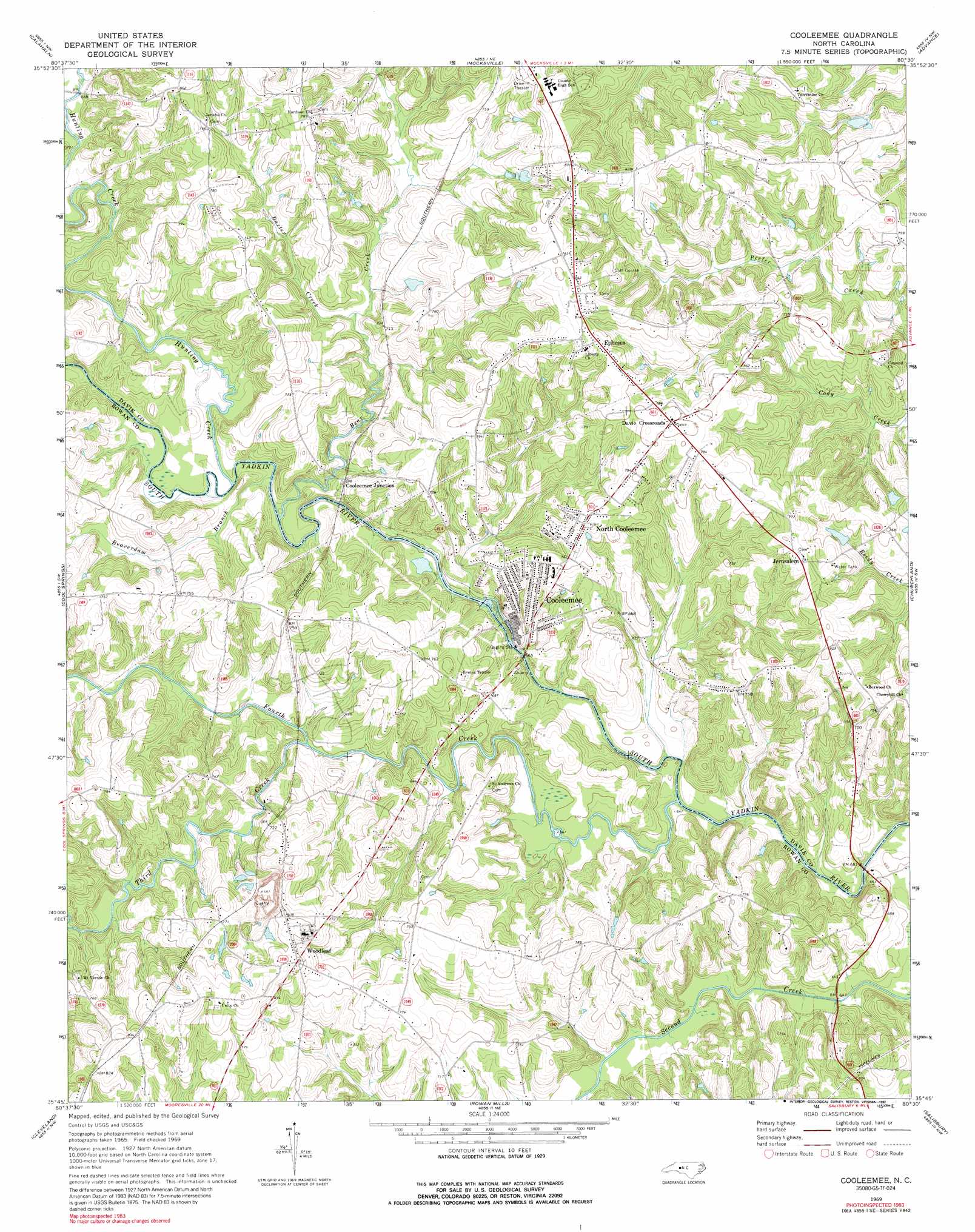
Cooleemee Topo Map North Carolina
To zoom in, hover over the map of Cooleemee
USGS Topo Quad 35080g5 - 1:24,000 scale
| Topo Map Name: | Cooleemee |
| USGS Topo Quad ID: | 35080g5 |
| Print Size: | ca. 21 1/4" wide x 27" high |
| Southeast Coordinates: | 35.75° N latitude / 80.5° W longitude |
| Map Center Coordinates: | 35.8125° N latitude / 80.5625° W longitude |
| U.S. State: | NC |
| Filename: | o35080g5.jpg |
| Download Map JPG Image: | Cooleemee topo map 1:24,000 scale |
| Map Type: | Topographic |
| Topo Series: | 7.5´ |
| Map Scale: | 1:24,000 |
| Source of Map Images: | United States Geological Survey (USGS) |
| Alternate Map Versions: |
Cooleemee NC 1969, updated 1972 Download PDF Buy paper map Cooleemee NC 1969, updated 1992 Download PDF Buy paper map Cooleemee NC 2010 Download PDF Buy paper map Cooleemee NC 2013 Download PDF Buy paper map Cooleemee NC 2016 Download PDF Buy paper map |
1:24,000 Topo Quads surrounding Cooleemee
Brooks Crossroads |
Lone Hickory |
Farmington |
Clemmons |
Winston-Salem West |
Harmony |
Calahaln |
Mocksville |
Advance |
Welcome |
Statesville East |
Cool Springs |
Cooleemee |
Churchland |
Lexington West |
Shepherds |
Cleveland |
Rowan Mills |
Salisbury |
Southmont |
Mooresville |
Enochville |
China Grove |
Rockwell |
Gold Hill |
> Back to 35080e1 at 1:100,000 scale
> Back to 35080a1 at 1:250,000 scale
> Back to U.S. Topo Maps home
Cooleemee topo map: Gazetteer
Cooleemee: Airports
Tara Field elevation 215m 705′Cooleemee: Dams
Cooleemee Dam elevation 197m 646′Daniels Lake Dam elevation 221m 725′
Hoffners Lake Dam elevation 218m 715′
Cooleemee: Populated Places
Cooleemee elevation 218m 715′Cooleemee Junction elevation 211m 692′
Davie Crossroads elevation 245m 803′
Ephesus elevation 250m 820′
Frohock Mill site elevation 201m 659′
Jerusalem elevation 241m 790′
North Cooleemee elevation 238m 780′
Woodleaf elevation 245m 803′
Cooleemee: Post Offices
Augusta Post Office (historical) elevation 221m 725′Jerusalem Post Office (historical) elevation 241m 790′
Tennyson Post Office (historical) elevation 212m 695′
Cooleemee: Reservoirs
Burlington Mills Lake elevation 197m 646′Daniels Lake elevation 221m 725′
Hoffners Lake elevation 218m 715′
Cooleemee: Streams
Baxter Creek elevation 204m 669′Bear Creek elevation 199m 652′
Beaverdam Branch elevation 201m 659′
Fourth Creek elevation 193m 633′
Hunting Creek elevation 199m 652′
Third Creek elevation 198m 649′
Cooleemee digital topo map on disk
Buy this Cooleemee topo map showing relief, roads, GPS coordinates and other geographical features, as a high-resolution digital map file on DVD:
South Carolina, Western North Carolina & Northeastern Georgia
Buy digital topo maps: South Carolina, Western North Carolina & Northeastern Georgia