Kings Mountain Topo Map North Carolina
To zoom in, hover over the map of Kings Mountain
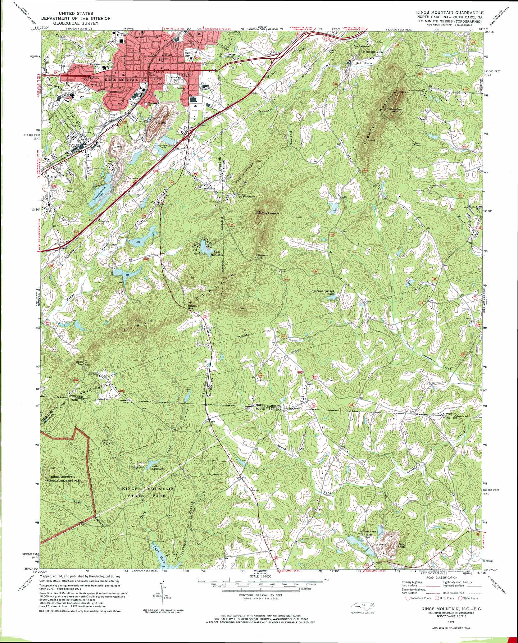
USGS Topo Quad 35081b3 - 1:24,000 scale
| Topo Map Name: | Kings Mountain |
| USGS Topo Quad ID: | 35081b3 |
| Print Size: | ca. 21 1/4" wide x 27" high |
| Southeast Coordinates: | 35.125° N latitude / 81.25° W longitude |
| Map Center Coordinates: | 35.1875° N latitude / 81.3125° W longitude |
| U.S. States: | NC, SC |
| Filename: | o35081b3.jpg |
| Download Map JPG Image: | Kings Mountain topo map 1:24,000 scale |
| Map Type: | Topographic |
| Topo Series: | 7.5´ |
| Map Scale: | 1:24,000 |
| Source of Map Images: | United States Geological Survey (USGS) |
| Alternate Map Versions: |
Kings Mountain NC 1971, updated 1973 Download PDF Buy paper map Kings Mountain NC 1976, updated 1978 Download PDF Buy paper map Kings Mountain NC 1993, updated 1996 Download PDF Buy paper map Kings Mountain NC 1997, updated 2000 Download PDF Buy paper map Kings Mountain NC 2011 Download PDF Buy paper map Kings Mountain NC 2013 Download PDF Buy paper map Kings Mountain NC 2016 Download PDF Buy paper map |
1:24,000 Topo Quads surrounding Kings Mountain
Lawndale |
Cherryville |
Lincolnton West |
Lincolnton East |
Lowesville |
Shelby |
Waco |
Bessemer City |
Gastonia North |
Mount Holly |
Blacksburg North |
Grover |
Kings Mountain |
Gastonia South |
Belmont |
Blacksburg South |
Kings Creek |
Filbert |
Clover |
Lake Wylie |
Wilkinsville |
Hickory Grove |
Sharon |
Tirzah |
Rock Hill West |
> Back to 35081a1 at 1:100,000 scale
> Back to 35080a1 at 1:250,000 scale
> Back to U.S. Topo Maps home
Kings Mountain topo map: Gazetteer
Kings Mountain: Dams
Executive Club Dam elevation 256m 839′Foote Mineral Reservoir Dam elevation 258m 846′
Foote Mineral Tailings Pond Dam elevation 270m 885′
Kings Mountain City Lake Number Two elevation 255m 836′
Kings Mountain Mica Company Dam elevation 247m 810′
Kings Mountain Number One Dam elevation 245m 803′
Lake Crawford Dam D-3639 elevation 214m 702′
Lake Montonia Dam elevation 262m 859′
Shorts Lake Dam elevation 252m 826′
Sparrow Springs Lake Dam elevation 244m 800′
Upper Whiteside Dam elevation 233m 764′
Kings Mountain: Gaps
Dixon Gap elevation 303m 994′Sherrars Gap elevation 347m 1138′
Stepps Gap elevation 316m 1036′
Kings Mountain: Lakes
Lake Montonia elevation 276m 905′Kings Mountain: Parks
Crowders Mountain State Park elevation 283m 928′Deal Park elevation 287m 941′
Kings Mountain State Park elevation 235m 770′
Kings Mountain: Pillars
The Pinnacle elevation 445m 1459′Kings Mountain: Populated Places
Kings Mountain elevation 307m 1007′Mountain View elevation 231m 757′
Kings Mountain: Post Offices
Kings Mountain Post Office elevation 306m 1003′Kings Mountain: Reservoirs
Executive Club Lake elevation 256m 839′Foote Mineral Reservoir elevation 258m 846′
Foote Mineral Tailings Pond elevation 270m 885′
Kings Mountain City Lake Number Two elevation 255m 836′
Kings Mountain Mica Company Lake elevation 247m 810′
Kings Mountain Number One Lake elevation 245m 803′
Lake Crawford elevation 214m 702′
Lake Montania elevation 262m 859′
Shorts Lake elevation 252m 826′
Sparrow Springs Lake elevation 244m 800′
Kings Mountain: Ridges
Kings Mountain elevation 357m 1171′Yellow Ridge elevation 343m 1125′
Kings Mountain: Streams
Jennings Branch elevation 203m 666′McGill Creek elevation 233m 764′
Squirrel Branch elevation 243m 797′
Kings Mountain: Summits
Crowders Mountain elevation 460m 1509′Henry Knob elevation 344m 1128′
Kings Mountain: Valleys
Love Valley elevation 261m 856′Kings Mountain digital topo map on disk
Buy this Kings Mountain topo map showing relief, roads, GPS coordinates and other geographical features, as a high-resolution digital map file on DVD:
South Carolina, Western North Carolina & Northeastern Georgia
Buy digital topo maps: South Carolina, Western North Carolina & Northeastern Georgia