Chesnee Topo Map North Carolina
To zoom in, hover over the map of Chesnee
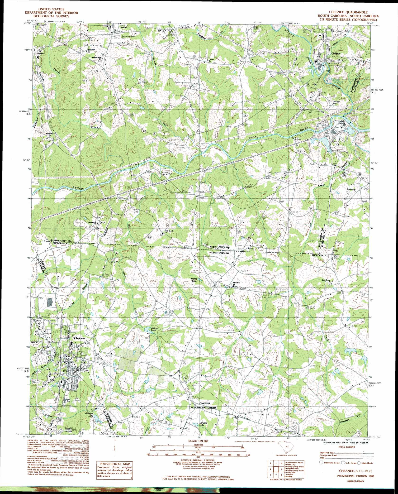
USGS Topo Quad 35081b7 - 1:24,000 scale
| Topo Map Name: | Chesnee |
| USGS Topo Quad ID: | 35081b7 |
| Print Size: | ca. 21 1/4" wide x 27" high |
| Southeast Coordinates: | 35.125° N latitude / 81.75° W longitude |
| Map Center Coordinates: | 35.1875° N latitude / 81.8125° W longitude |
| U.S. States: | NC, SC |
| Filename: | o35081b7.jpg |
| Download Map JPG Image: | Chesnee topo map 1:24,000 scale |
| Map Type: | Topographic |
| Topo Series: | 7.5´ |
| Map Scale: | 1:24,000 |
| Source of Map Images: | United States Geological Survey (USGS) |
| Alternate Map Versions: |
Cowpens NE SC 1975, updated 1979 Download PDF Buy paper map Chesnee SC 1983, updated 1983 Download PDF Buy paper map Chesnee SC 1993, updated 1996 Download PDF Buy paper map Chesnee SC 2011 Download PDF Buy paper map Chesnee SC 2014 Download PDF Buy paper map |
1:24,000 Topo Quads surrounding Chesnee
Shingle Hollow |
Rutherfordton North |
Sunshine |
Polkville |
Lawndale |
Pea Ridge |
Rutherfordton South |
Forest City |
Boiling Springs North |
Shelby |
Fingerville West |
Fingerville East |
Chesnee |
Boiling Springs South |
Blacksburg North |
Inman |
Valley Falls |
Cowpens |
Gaffney |
Blacksburg South |
Wellford |
Spartanburg |
Pacolet |
Pacolet Mills |
Wilkinsville |
> Back to 35081a1 at 1:100,000 scale
> Back to 35080a1 at 1:250,000 scale
> Back to U.S. Topo Maps home
Chesnee topo map: Gazetteer
Chesnee: Airports
Spicers Airport elevation 255m 836′State Line Ultraport elevation 270m 885′
Chesnee: Dams
Burlington Dam elevation 229m 751′Cudds Creek Pond Dam D-3322 elevation 268m 879′
South Carolina Noname 11015 D-3400 Dam elevation 274m 898′
Chesnee: Lakes
Greenes Lake elevation 256m 839′Harris Lake elevation 272m 892′
Chesnee: Parks
Cowpens National Battlefield elevation 294m 964′Chesnee: Populated Places
Brice elevation 270m 885′Chesnee elevation 272m 892′
Cliffside elevation 225m 738′
Ezell (historical) elevation 298m 977′
Harris elevation 241m 790′
State Line elevation 286m 938′
Chesnee: Reservoirs
Burlington Lake elevation 229m 751′Cudds Creek Pond elevation 268m 879′
Jolleys Lake elevation 258m 846′
Scruggs Lake elevation 287m 941′
Chesnee: Streams
Big Horse Creek elevation 208m 682′Cane Creek elevation 207m 679′
Cane Creek elevation 205m 672′
Floyds Creek elevation 206m 675′
Goodes Creek elevation 207m 679′
Hills Creek elevation 217m 711′
Little Horse Creek elevation 237m 777′
Riddles Creek elevation 206m 675′
Second Broad River elevation 202m 662′
Chesnee digital topo map on disk
Buy this Chesnee topo map showing relief, roads, GPS coordinates and other geographical features, as a high-resolution digital map file on DVD:
South Carolina, Western North Carolina & Northeastern Georgia
Buy digital topo maps: South Carolina, Western North Carolina & Northeastern Georgia