Shelby Topo Map North Carolina
To zoom in, hover over the map of Shelby
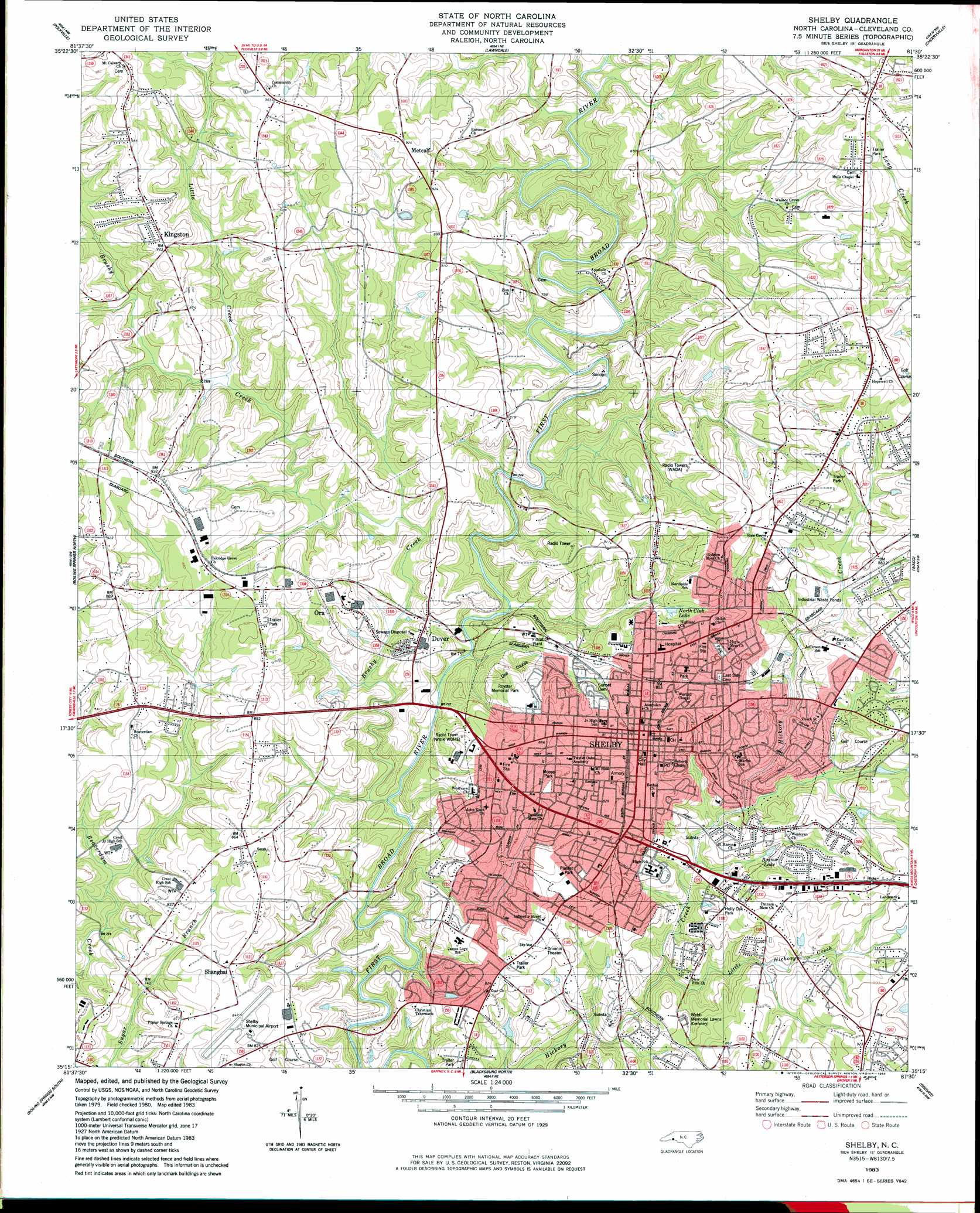
USGS Topo Quad 35081c5 - 1:24,000 scale
| Topo Map Name: | Shelby |
| USGS Topo Quad ID: | 35081c5 |
| Print Size: | ca. 21 1/4" wide x 27" high |
| Southeast Coordinates: | 35.25° N latitude / 81.5° W longitude |
| Map Center Coordinates: | 35.3125° N latitude / 81.5625° W longitude |
| U.S. State: | NC |
| Filename: | o35081c5.jpg |
| Download Map JPG Image: | Shelby topo map 1:24,000 scale |
| Map Type: | Topographic |
| Topo Series: | 7.5´ |
| Map Scale: | 1:24,000 |
| Source of Map Images: | United States Geological Survey (USGS) |
| Alternate Map Versions: |
Shelby SE NC 1976, updated 1978 Download PDF Buy paper map Shelby NC 1983, updated 1983 Download PDF Buy paper map Shelby NC 1983, updated 1983 Download PDF Buy paper map Shelby NC 2002, updated 2003 Download PDF Buy paper map Shelby NC 2010 Download PDF Buy paper map Shelby NC 2013 Download PDF Buy paper map Shelby NC 2016 Download PDF Buy paper map |
1:24,000 Topo Quads surrounding Shelby
Dysartsville |
Benn Knob |
Casar |
Banoak |
Reepsville |
Sunshine |
Polkville |
Lawndale |
Cherryville |
Lincolnton West |
Forest City |
Boiling Springs North |
Shelby |
Waco |
Bessemer City |
Chesnee |
Boiling Springs South |
Blacksburg North |
Grover |
Kings Mountain |
Cowpens |
Gaffney |
Blacksburg South |
Kings Creek |
Filbert |
> Back to 35081a1 at 1:100,000 scale
> Back to 35080a1 at 1:250,000 scale
> Back to U.S. Topo Maps home
Shelby topo map: Gazetteer
Shelby: Airports
Byers Airport (historical) elevation 264m 866′Shelby Municipal Airport elevation 257m 843′
Shelby: Areas
Thompson Garden elevation 259m 849′Shelby: Dams
Emile Gebel Dam elevation 250m 820′Shelby: Parks
Central Shelby Historic District elevation 271m 889′Ezra Bridge Park elevation 259m 849′
George Blanton Memorial Stadium elevation 239m 784′
Hickory Creek Park elevation 240m 787′
Holly Oak Park elevation 240m 787′
Hoskins Park elevation 259m 849′
Jefferson Park elevation 270m 885′
Junior Women Club Park elevation 238m 780′
Marlwood Park elevation 283m 928′
Moose Park elevation 250m 820′
Optimist Park elevation 241m 790′
Plaster Park elevation 256m 839′
Shelby: Populated Places
Allen Acres elevation 286m 938′Allendale elevation 264m 866′
Briarwood Townhouses elevation 264m 866′
Brittain Village elevation 237m 777′
Camden Acres elevation 243m 797′
Carosel Apartments elevation 265m 869′
Chestnut Apartments elevation 256m 839′
Cline Street Apartments elevation 248m 813′
Country Club Gardens elevation 259m 849′
Crestmont Heights elevation 264m 866′
Dover elevation 249m 816′
Eastway Heights elevation 249m 816′
Fairway Heights elevation 266m 872′
Fullerton Apartments elevation 269m 882′
Gidney Homes elevation 265m 869′
Gilbert Green Apartments elevation 263m 862′
Hickory Creek Apartments elevation 255m 836′
Hillsdale elevation 247m 810′
Hollyoak Apartments elevation 241m 790′
Idlewild Terrace Apartments elevation 256m 839′
Kenmon Acres elevation 275m 902′
Kenmon Apartments elevation 265m 869′
Kingstown elevation 282m 925′
Kingswood Apartments elevation 268m 879′
Lake Christopher Apartments elevation 268m 879′
Lake Street Apartments elevation 262m 859′
Logan Street Public Housing elevation 265m 869′
Meadowood elevation 267m 875′
Metcalf elevation 280m 918′
Old Farm elevation 248m 813′
Olsen Homes elevation 242m 793′
Ora elevation 248m 813′
Osborne Apartments elevation 254m 833′
Park Sumter Terrace Apartments elevation 267m 875′
Pinehurst Acres elevation 282m 925′
Poplar Springs elevation 248m 813′
Ramblewood Apartments elevation 257m 843′
Riverbend Acres elevation 247m 810′
Rocky Brook elevation 262m 859′
Rollingwood elevation 266m 872′
Ross Grove elevation 286m 938′
Sedgefield Apartments elevation 247m 810′
Shanghai elevation 252m 826′
Sharon Apartments elevation 268m 879′
Shelby elevation 262m 859′
Sprangler Apartments elevation 261m 856′
Stone Hedge Apartments elevation 265m 869′
The Meadow Apartments elevation 251m 823′
Valleyhall elevation 264m 866′
Vestavia elevation 283m 928′
Village Square Townhouses elevation 271m 889′
Washington Heights elevation 233m 764′
Westwood Heights elevation 228m 748′
Woodsdale elevation 280m 918′
Zion elevation 250m 820′
Shelby: Post Offices
Shelby Post Office elevation 265m 869′Shelby: Reservoirs
Beams Lake elevation 242m 793′Emile Gebel Lake elevation 250m 820′
North Club Lake elevation 238m 780′
Shelby: Streams
Big Harris Creek elevation 225m 738′Brushy Creek elevation 206m 675′
Little Creek elevation 240m 787′
Little Harris Creek elevation 228m 748′
Little Hickory Creek elevation 213m 698′
Shelby digital topo map on disk
Buy this Shelby topo map showing relief, roads, GPS coordinates and other geographical features, as a high-resolution digital map file on DVD:
South Carolina, Western North Carolina & Northeastern Georgia
Buy digital topo maps: South Carolina, Western North Carolina & Northeastern Georgia