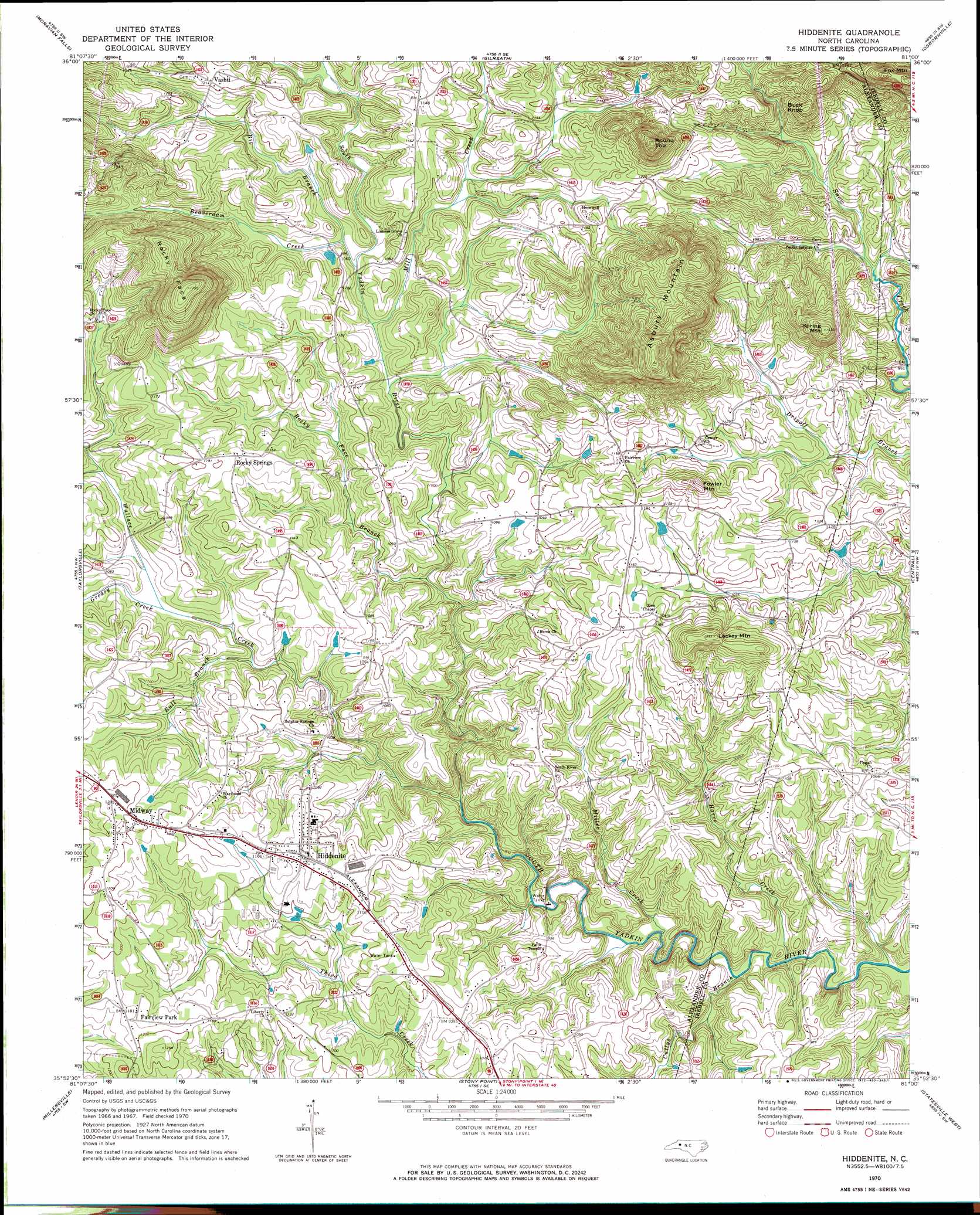
Hiddenite Topo Map North Carolina
To zoom in, hover over the map of Hiddenite
USGS Topo Quad 35081h1 - 1:24,000 scale
| Topo Map Name: | Hiddenite |
| USGS Topo Quad ID: | 35081h1 |
| Print Size: | ca. 21 1/4" wide x 27" high |
| Southeast Coordinates: | 35.875° N latitude / 81° W longitude |
| Map Center Coordinates: | 35.9375° N latitude / 81.0625° W longitude |
| U.S. State: | NC |
| Filename: | o35081h1.jpg |
| Download Map JPG Image: | Hiddenite topo map 1:24,000 scale |
| Map Type: | Topographic |
| Topo Series: | 7.5´ |
| Map Scale: | 1:24,000 |
| Source of Map Images: | United States Geological Survey (USGS) |
| Alternate Map Versions: |
Hiddenite NC 1970, updated 1972 Download PDF Buy paper map Hiddenite NC 2010 Download PDF Buy paper map Hiddenite NC 2013 Download PDF Buy paper map Hiddenite NC 2016 Download PDF Buy paper map |
1:24,000 Topo Quads surrounding Hiddenite
Purlear |
Wilkesboro |
Roaring River |
Ronda |
Elkin South |
Boomer |
Moravian Falls |
Gilreath |
Osbornville |
Brooks Crossroads |
Ellendale |
Taylorsville |
Hiddenite |
Central |
Harmony |
Bethlehem |
Millersville |
Stony Point |
Statesville West |
Statesville East |
Hickory |
Newton |
Catawba |
Troutman |
Shepherds |
> Back to 35081e1 at 1:100,000 scale
> Back to 35080a1 at 1:250,000 scale
> Back to U.S. Topo Maps home
Hiddenite topo map: Gazetteer
Hiddenite: Airports
Gryder-Teague Airport elevation 347m 1138′Hiddenite: Populated Places
Fairview Park elevation 360m 1181′Hiddenite elevation 353m 1158′
Midway elevation 369m 1210′
New Hope (historical) elevation 343m 1125′
Rocky Springs elevation 360m 1181′
Vashti elevation 369m 1210′
Hiddenite: Streams
Beaverdam Creek elevation 311m 1020′Big Branch elevation 309m 1013′
Bull Branch elevation 302m 990′
Cullys Branch elevation 256m 839′
Greasy Creek elevation 309m 1013′
Harve Creek elevation 250m 820′
Mill Creek elevation 308m 1010′
Miller Creek elevation 256m 839′
Rocky Face Branch elevation 294m 964′
Wallace Creek elevation 275m 902′
Hiddenite: Summits
Asbury Mountain elevation 547m 1794′Buck Knob elevation 445m 1459′
Fowler Mountain elevation 402m 1318′
Lackey Mountain elevation 423m 1387′
Rocky Face elevation 547m 1794′
Round Top elevation 502m 1646′
Spring Mountain elevation 464m 1522′
Hiddenite digital topo map on disk
Buy this Hiddenite topo map showing relief, roads, GPS coordinates and other geographical features, as a high-resolution digital map file on DVD:
South Carolina, Western North Carolina & Northeastern Georgia
Buy digital topo maps: South Carolina, Western North Carolina & Northeastern Georgia