Lenoir Topo Map North Carolina
To zoom in, hover over the map of Lenoir
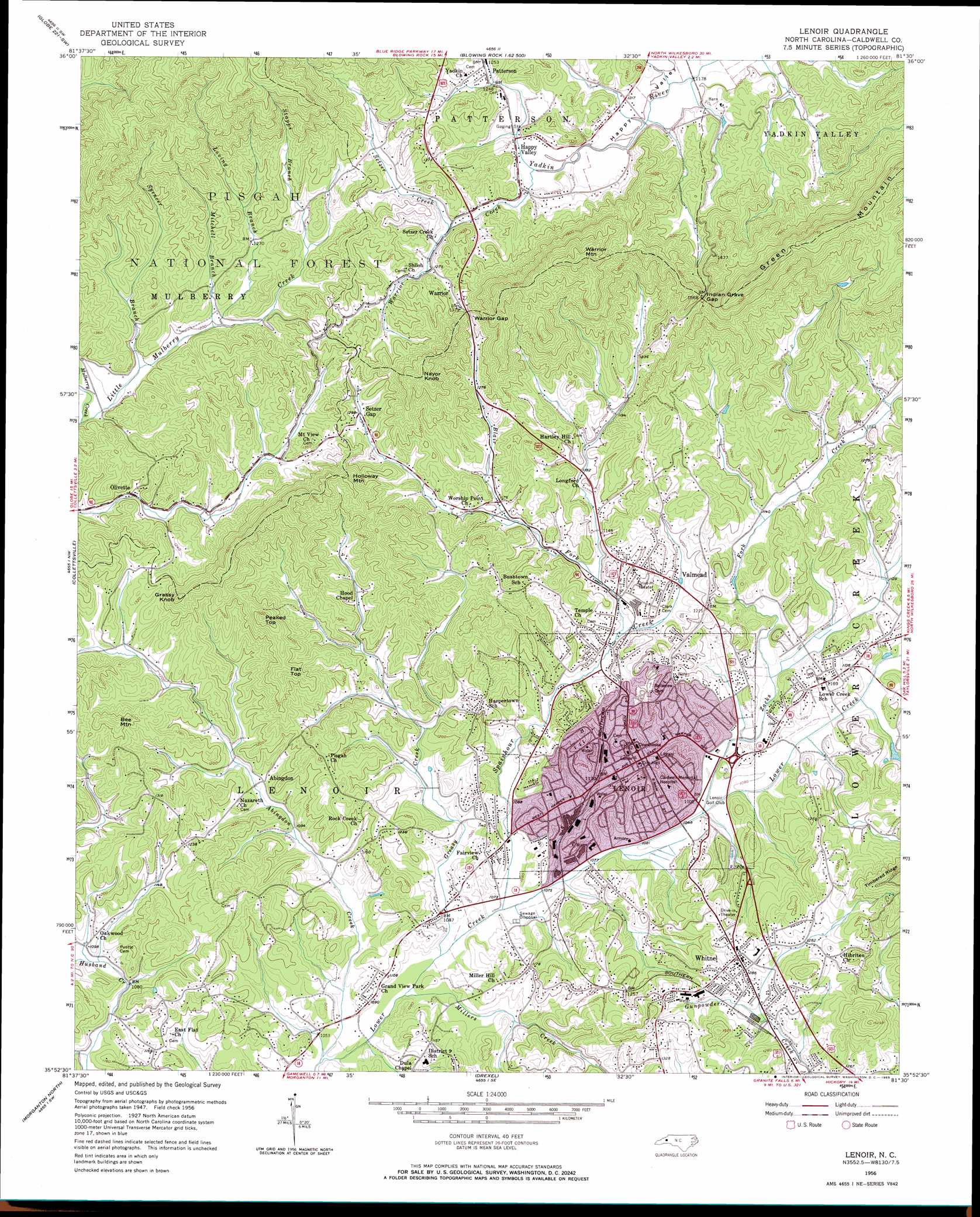
USGS Topo Quad 35081h5 - 1:24,000 scale
| Topo Map Name: | Lenoir |
| USGS Topo Quad ID: | 35081h5 |
| Print Size: | ca. 21 1/4" wide x 27" high |
| Southeast Coordinates: | 35.875° N latitude / 81.5° W longitude |
| Map Center Coordinates: | 35.9375° N latitude / 81.5625° W longitude |
| U.S. State: | NC |
| Filename: | o35081h5.jpg |
| Download Map JPG Image: | Lenoir topo map 1:24,000 scale |
| Map Type: | Topographic |
| Topo Series: | 7.5´ |
| Map Scale: | 1:24,000 |
| Source of Map Images: | United States Geological Survey (USGS) |
| Alternate Map Versions: |
Lenoir NC 1956, updated 1958 Download PDF Buy paper map Lenoir NC 1956, updated 1965 Download PDF Buy paper map Lenoir NC 1993, updated 1996 Download PDF Buy paper map Lenoir NC 1994, updated 1998 Download PDF Buy paper map Lenoir NC 2011 Download PDF Buy paper map Lenoir NC 2013 Download PDF Buy paper map Lenoir NC 2016 Download PDF Buy paper map |
| FStopo: | US Forest Service topo Lenoir is available: Download FStopo PDF Download FStopo TIF |
1:24,000 Topo Quads surrounding Lenoir
Valle Crucis |
Boone |
Deep Gap |
Maple Springs |
Purlear |
Grandfather Mountain |
Globe |
Buffalo Cove |
Grandin |
Boomer |
Chestnut Mountain |
Collettsville |
Lenoir |
Kings Creek |
Ellendale |
Oak Hill |
Morganton North |
Drexel |
Granite Falls |
Bethlehem |
Glen Alpine |
Morganton South |
Valdese |
Longview |
Hickory |
> Back to 35081e1 at 1:100,000 scale
> Back to 35080a1 at 1:250,000 scale
> Back to U.S. Topo Maps home
Lenoir topo map: Gazetteer
Lenoir: Dams
High Lake Dam elevation 472m 1548′Lenoir: Gaps
Indian Grave Gap elevation 482m 1581′Setzer Gap elevation 394m 1292′
Warrior Gap elevation 438m 1437′
Lenoir: Populated Places
Abingdon elevation 339m 1112′British Woods elevation 338m 1108′
Charlesmont elevation 360m 1181′
Corola Hills elevation 345m 1131′
Glenburine (historical) elevation 335m 1099′
Grand View Park elevation 331m 1085′
Happy Valley elevation 372m 1220′
Heritage Hills elevation 344m 1128′
Honey Hill elevation 335m 1099′
Indian Hills elevation 469m 1538′
Lenoir elevation 357m 1171′
Olivette elevation 355m 1164′
Patterson elevation 383m 1256′
Pinewood elevation 363m 1190′
Queens Acres elevation 341m 1118′
Tranquil Hill elevation 372m 1220′
Tremont Park elevation 382m 1253′
Valmead elevation 368m 1207′
Warrior elevation 405m 1328′
West Lenoir elevation 329m 1079′
Whitnel elevation 392m 1286′
Lenoir: Reservoirs
High Lake elevation 472m 1548′Lenoir: Ridges
Green Mountain elevation 640m 2099′Lenoir: Streams
Abingdon Creek elevation 318m 1043′Blair Fork elevation 321m 1053′
Coffey Branch elevation 359m 1177′
Greasy Creek elevation 319m 1046′
Little Mulberry Creek elevation 348m 1141′
Long Branch elevation 339m 1112′
Loving Branch elevation 363m 1190′
Mill Pond Branch elevation 354m 1161′
Millers Creek elevation 317m 1040′
Mitchell Branch elevation 362m 1187′
Setzer Creek elevation 380m 1246′
Spencer Branch elevation 354m 1161′
Stapps Branch elevation 383m 1256′
Warrior Creek elevation 368m 1207′
Zacks Fork Creek elevation 330m 1082′
Lenoir: Summits
Bee Mountain elevation 467m 1532′Flat Top elevation 480m 1574′
Grassy Knob elevation 498m 1633′
Holloway Mountain elevation 481m 1578′
Nayor Knob elevation 550m 1804′
Peaked Top elevation 525m 1722′
Warrior Mountain elevation 634m 2080′
Lenoir: Valleys
Happy Valley elevation 360m 1181′Lenoir digital topo map on disk
Buy this Lenoir topo map showing relief, roads, GPS coordinates and other geographical features, as a high-resolution digital map file on DVD:
South Carolina, Western North Carolina & Northeastern Georgia
Buy digital topo maps: South Carolina, Western North Carolina & Northeastern Georgia