Chestnut Mountain Topo Map North Carolina
To zoom in, hover over the map of Chestnut Mountain
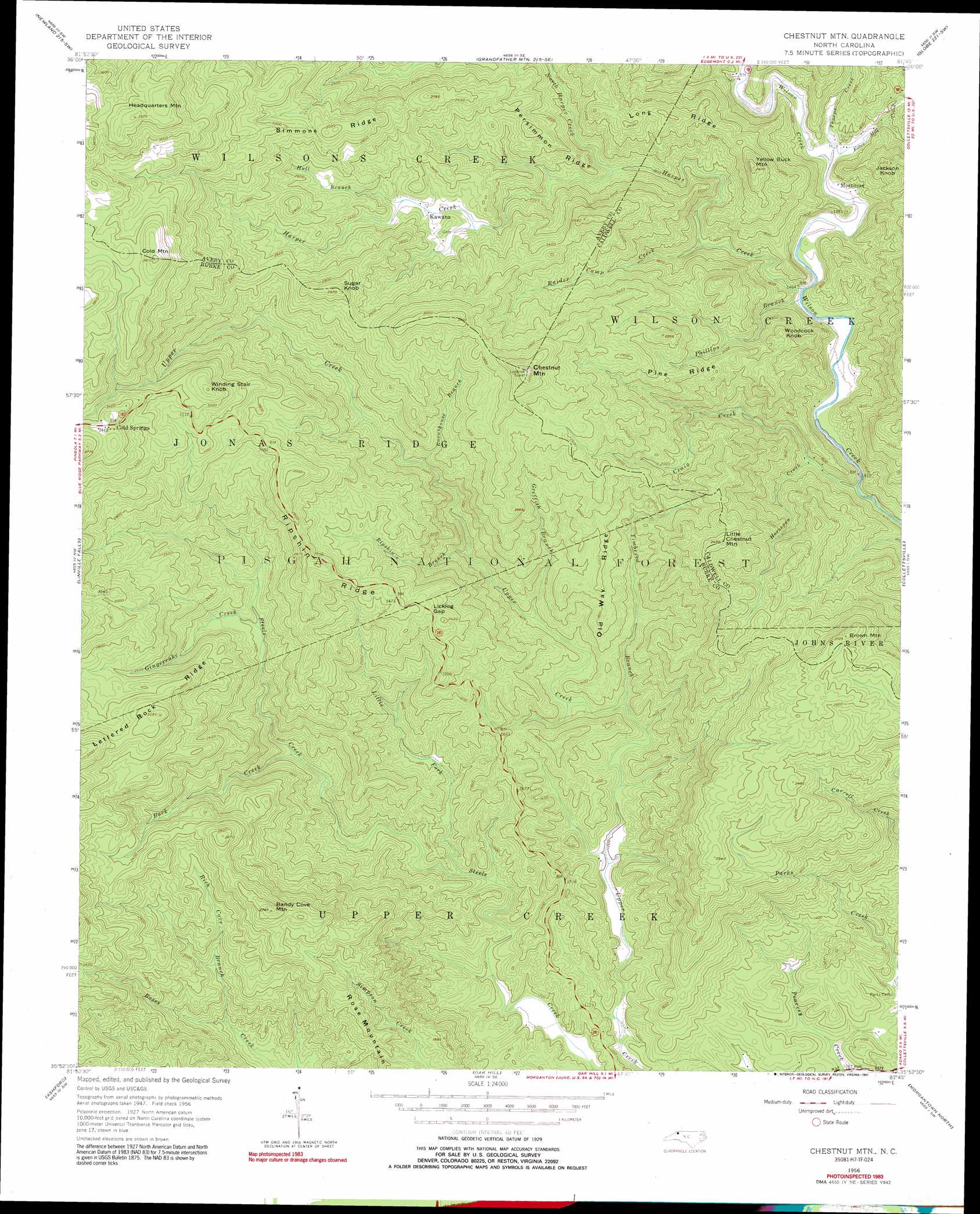
USGS Topo Quad 35081h7 - 1:24,000 scale
| Topo Map Name: | Chestnut Mountain |
| USGS Topo Quad ID: | 35081h7 |
| Print Size: | ca. 21 1/4" wide x 27" high |
| Southeast Coordinates: | 35.875° N latitude / 81.75° W longitude |
| Map Center Coordinates: | 35.9375° N latitude / 81.8125° W longitude |
| U.S. State: | NC |
| Filename: | o35081h7.jpg |
| Download Map JPG Image: | Chestnut Mountain topo map 1:24,000 scale |
| Map Type: | Topographic |
| Topo Series: | 7.5´ |
| Map Scale: | 1:24,000 |
| Source of Map Images: | United States Geological Survey (USGS) |
| Alternate Map Versions: |
Chestnut Mtn. NC 1956, updated 1958 Download PDF Buy paper map Chestnut Mtn. NC 1956, updated 1966 Download PDF Buy paper map Chestnut Mtn. NC 1956, updated 1973 Download PDF Buy paper map Chestnut Mountain NC 1956, updated 1991 Download PDF Buy paper map Chestnut Mountain NC 1993, updated 1995 Download PDF Buy paper map Chestnut Mountain NC 1994, updated 1998 Download PDF Buy paper map Chestnut Mountain NC 2011 Download PDF Buy paper map Chestnut Mountain NC 2013 Download PDF Buy paper map Chestnut Mountain NC 2016 Download PDF Buy paper map |
| FStopo: | US Forest Service topo Chestnut Mountain is available: Download FStopo PDF Download FStopo TIF |
1:24,000 Topo Quads surrounding Chestnut Mountain
White Rocks Mountain |
Elk Park |
Valle Crucis |
Boone |
Deep Gap |
Carvers Gap |
Newland |
Grandfather Mountain |
Globe |
Buffalo Cove |
Spruce Pine |
Linville Falls |
Chestnut Mountain |
Collettsville |
Lenoir |
Little Switzerland |
Ashford |
Oak Hill |
Morganton North |
Drexel |
Marion West |
Marion East |
Glen Alpine |
Morganton South |
Valdese |
> Back to 35081e1 at 1:100,000 scale
> Back to 35080a1 at 1:250,000 scale
> Back to U.S. Topo Maps home
Chestnut Mountain topo map: Gazetteer
Chestnut Mountain: Gaps
Licklog Gap elevation 719m 2358′Chestnut Mountain: Parks
Daniel Boone Wildlife Management Area elevation 737m 2417′Daniel Boone Wildlife Management Area elevation 927m 3041′
Chestnut Mountain: Populated Places
Cold Springs elevation 1052m 3451′Kawana elevation 700m 2296′
Mortimer elevation 456m 1496′
Chestnut Mountain: Ridges
Lettered Rock Ridge elevation 884m 2900′Old Way Ridge elevation 609m 1998′
Persimmon Ridge elevation 701m 2299′
Pine Ridge elevation 698m 2290′
Ripshin Ridge elevation 846m 2775′
Rose Mountain elevation 646m 2119′
Simmons Ridge elevation 926m 3038′
Chestnut Mountain: Streams
Buck Creek elevation 450m 1476′Burnthouse Branch elevation 586m 1922′
Craig Creek elevation 425m 1394′
Estes Mill Creek elevation 454m 1489′
Gingercake Creek elevation 605m 1984′
Griffith Branch elevation 418m 1371′
Harper Creek elevation 440m 1443′
Horsepen Creek elevation 446m 1463′
Hull Branch elevation 694m 2276′
Little Fork elevation 382m 1253′
Phillips Branch elevation 437m 1433′
Raider Camp Creek elevation 473m 1551′
Rich Cove Branch elevation 478m 1568′
Ripshin Branch elevation 468m 1535′
Thorps Creek elevation 454m 1489′
Timbered Branch elevation 381m 1250′
Chestnut Mountain: Summits
Bandy Cove Mountain elevation 822m 2696′Brown Mountain elevation 832m 2729′
Chestnut Mountain elevation 1010m 3313′
Cold Mountain elevation 1160m 3805′
Headquarters Mountain elevation 1212m 3976′
Jackson Knob elevation 641m 2103′
Little Chestnut Mountain elevation 756m 2480′
Sugar Knob elevation 909m 2982′
Windling Stair Knob elevation 1029m 3375′
Woodcock Knob elevation 635m 2083′
Yellow Buck Mountain elevation 751m 2463′
Chestnut Mountain digital topo map on disk
Buy this Chestnut Mountain topo map showing relief, roads, GPS coordinates and other geographical features, as a high-resolution digital map file on DVD:
South Carolina, Western North Carolina & Northeastern Georgia
Buy digital topo maps: South Carolina, Western North Carolina & Northeastern Georgia