Brevard Topo Map North Carolina
To zoom in, hover over the map of Brevard
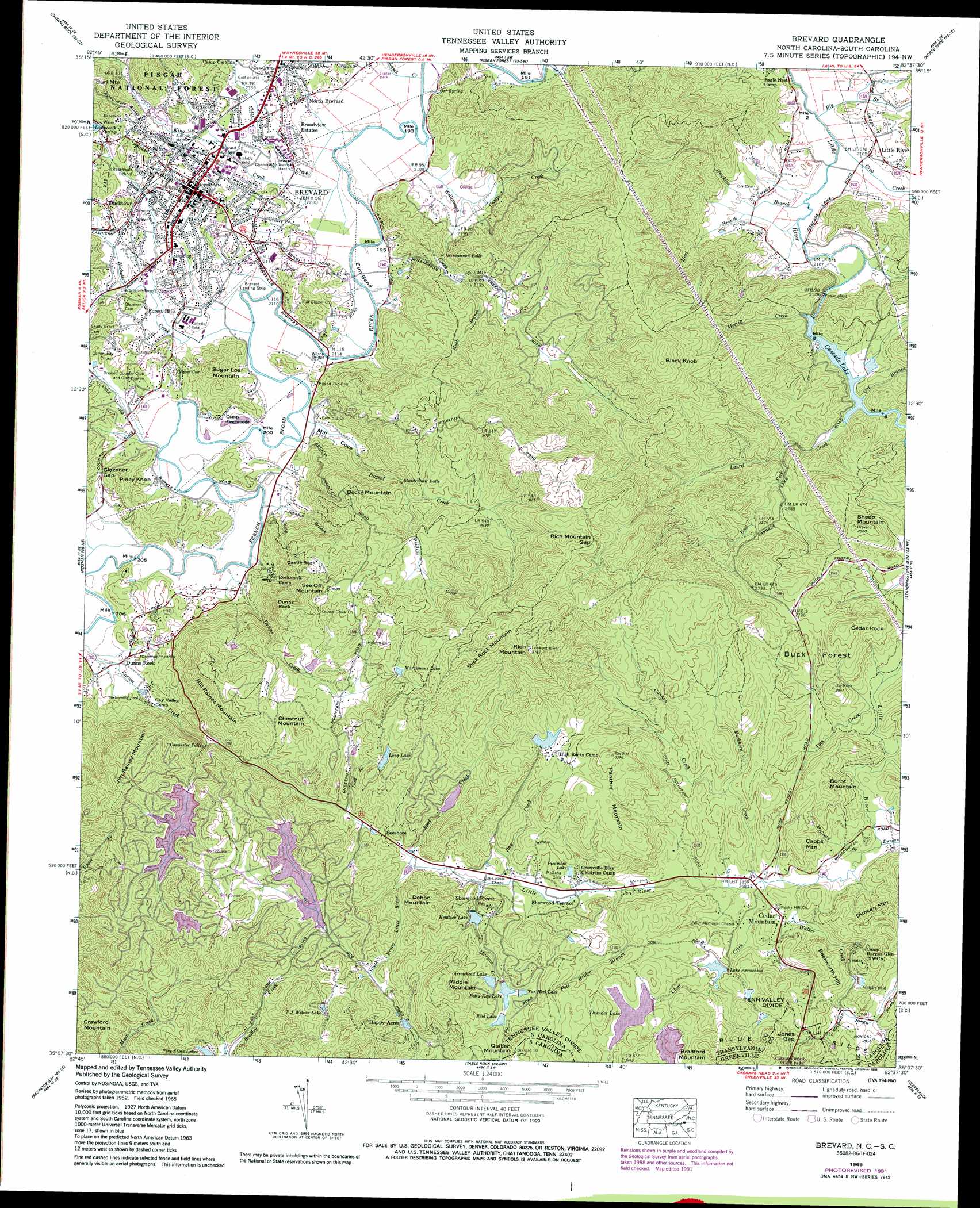
USGS Topo Quad 35082b6 - 1:24,000 scale
| Topo Map Name: | Brevard |
| USGS Topo Quad ID: | 35082b6 |
| Print Size: | ca. 21 1/4" wide x 27" high |
| Southeast Coordinates: | 35.125° N latitude / 82.625° W longitude |
| Map Center Coordinates: | 35.1875° N latitude / 82.6875° W longitude |
| U.S. States: | NC, SC |
| Filename: | o35082b6.jpg |
| Download Map JPG Image: | Brevard topo map 1:24,000 scale |
| Map Type: | Topographic |
| Topo Series: | 7.5´ |
| Map Scale: | 1:24,000 |
| Source of Map Images: | United States Geological Survey (USGS) |
| Alternate Map Versions: |
Brevard NC 1935 Download PDF Buy paper map Brevard NC 1945, updated 1956 Download PDF Buy paper map Brevard NC 1945, updated 1966 Download PDF Buy paper map Brevard NC 1946, updated 1947 Download PDF Buy paper map Brevard NC 1965, updated 1967 Download PDF Buy paper map Brevard NC 1965, updated 1972 Download PDF Buy paper map Brevard NC 1965, updated 1978 Download PDF Buy paper map Brevard NC 1965, updated 1991 Download PDF Buy paper map Brevard NC 1965, updated 1991 Download PDF Buy paper map Brevard NC 1997, updated 2001 Download PDF Buy paper map Brevard NC 2011 Download PDF Buy paper map Brevard NC 2013 Download PDF Buy paper map Brevard NC 2016 Download PDF Buy paper map |
| FStopo: | US Forest Service topo Brevard is available: Download FStopo PDF Download FStopo TIF |
1:24,000 Topo Quads surrounding Brevard
Waynesville |
Cruso |
Dunsmore Mountain |
Skyland |
Fruitland |
Sam Knob |
Shining Rock |
Pisgah Forest |
Horse Shoe |
Hendersonville |
Lake Toxaway |
Rosman |
Brevard |
Standingstone Mountain |
Zirconia |
Reid |
Eastatoe Gap |
Table Rock |
Cleveland |
Slater |
Salem |
Sunset |
Pickens |
Dacusville |
Paris Mountain |
> Back to 35082a1 at 1:100,000 scale
> Back to 35082a1 at 1:250,000 scale
> Back to U.S. Topo Maps home
Brevard topo map: Gazetteer
Brevard: Airports
Brevard Airport elevation 642m 2106′Brevard: Areas
Buck Forest elevation 835m 2739′Brevard: Bends
Elm Bend elevation 641m 2103′Brevard: Bridges
Elm Bend Bridge elevation 639m 2096′Wilson Bridge elevation 639m 2096′
Brevard: Cliffs
Castle Rock elevation 747m 2450′Dunns Rock elevation 786m 2578′
Brevard: Dams
Arrowhead Dam elevation 889m 2916′Artimus Owens Dam elevation 886m 2906′
Atagahi Lake Dam elevation 882m 2893′
Betty Kay Lake Dam elevation 887m 2910′
Boot Lake Dam elevation 888m 2913′
Camp Burgess Glen Dam elevation 903m 2962′
Cascade Lake Dam elevation 678m 2224′
Eagles Nest Dam elevation 910m 2985′
High Rock Dam elevation 960m 3149′
Lake Tiaroga Dam elevation 909m 2982′
Little River Camp Dam elevation 681m 2234′
Marchmans Dam elevation 915m 3001′
N Shore Lake Dam elevation 851m 2791′
Sequoyah Woods Lake Dam elevation 843m 2765′
Slick Rock Mountain Dam elevation 925m 3034′
Tarheel Lake Dam elevation 925m 3034′
Thunder Lake Dam elevation 895m 2936′
Ticoa Dam elevation 856m 2808′
Trout Lake Dam elevation 866m 2841′
W Cantrell Dam elevation 820m 2690′
Brevard: Falls
Connestee Falls elevation 772m 2532′Glencannon Falls elevation 705m 2312′
Maidenhair Falls elevation 713m 2339′
Brevard: Gaps
Glazener Gap elevation 687m 2253′Jones Gap elevation 905m 2969′
Jones Gap elevation 920m 3018′
Rich Mountain Gap elevation 968m 3175′
Brevard: Lakes
Betty-Kay Lake elevation 885m 2903′Brevard: Populated Places
Blue Ridge Overlook elevation 887m 2910′Brevard elevation 678m 2224′
Broadview Estates elevation 652m 2139′
Cedar Mountain elevation 830m 2723′
Connestee Falls elevation 864m 2834′
Deerwoods Estates elevation 676m 2217′
Ducktown elevation 672m 2204′
Dunns Rock elevation 657m 2155′
Emerald Hills Estates elevation 654m 2145′
Falls Creek elevation 737m 2417′
Fernwood elevation 699m 2293′
Forest Hills elevation 652m 2139′
Franklin Park elevation 655m 2148′
Glen Cannon elevation 709m 2326′
Hamilton Estates elevation 700m 2296′
Happy Acres elevation 970m 3182′
Hidden Valley elevation 745m 2444′
Knob Creek elevation 734m 2408′
Knob Hill elevation 738m 2421′
Knob Ridge elevation 753m 2470′
Little River elevation 644m 2112′
Loehencove Ridge elevation 663m 2175′
McCrary Acres elevation 657m 2155′
Millbrook Estates elevation 680m 2230′
Morgan Heights elevation 699m 2293′
North Brevard elevation 645m 2116′
Patton Mountain Estates elevation 638m 2093′
Pine Shore Lakes elevation 921m 3021′
Pisgah Forest Farms elevation 845m 2772′
Riverside Estates elevation 673m 2208′
Seeshore elevation 847m 2778′
Sequoyah Woods elevation 910m 2985′
Seven Springs elevation 679m 2227′
Sherwood Forest elevation 895m 2936′
Sherwood Ridge elevation 862m 2828′
Sherwood Terrace elevation 824m 2703′
Slick Rock elevation 909m 2982′
Stoney Brook elevation 721m 2365′
Sweetwater Farms elevation 741m 2431′
Brevard: Reservoirs
Arrowhead Lake elevation 889m 2916′Atagahi Lake elevation 882m 2893′
Betty Kay Lake elevation 887m 2910′
Boot Lake elevation 888m 2913′
Camp Burgess Glen Lake elevation 903m 2962′
Cascade Lake elevation 678m 2224′
Eagles Nest Lake elevation 910m 2985′
Hemlock Lake elevation 854m 2801′
High Rock Lake elevation 960m 3149′
Lake Arrowhead elevation 847m 2778′
Lake Taroga elevation 909m 2982′
Little River Camp Lake elevation 681m 2234′
Long Lake elevation 912m 2992′
Marchmans Lake elevation 915m 3001′
N Shore Lake elevation 851m 2791′
Noname elevation 889m 2916′
Noname elevation 886m 2906′
Piedmont Lake elevation 835m 2739′
Pine Shore Lakes elevation 851m 2791′
Sequoyah Woods Lake elevation 843m 2765′
Slick Rock Mountain Lake elevation 925m 3034′
Sonata Lake elevation 679m 2227′
T J Wilson Lake elevation 915m 3001′
Tar Heel Lake elevation 886m 2906′
Tarheel Lake elevation 925m 3034′
Thunder Lake elevation 895m 2936′
Ticoa Lake elevation 856m 2808′
Trout Lake elevation 866m 2841′
W Cantrell Lake elevation 820m 2690′
Brevard: Springs
Dodsworth Spring elevation 687m 2253′Orr Spring elevation 647m 2122′
Brevard: Streams
Big Branch elevation 637m 2089′Brushy Creek elevation 664m 2178′
Buckhorn Creek elevation 819m 2687′
Camp Creek elevation 643m 2109′
Cannon Creek elevation 833m 2732′
Clear Creek elevation 819m 2687′
Cox Branch elevation 679m 2227′
Crab Creek elevation 637m 2089′
Duncan Creek elevation 814m 2670′
Dunns Creek elevation 645m 2116′
East Fork Laurel Creek elevation 704m 2309′
Graham Creek elevation 657m 2155′
Hanty Branch elevation 649m 2129′
Hart Branch elevation 639m 2096′
Hawkins Branch elevation 638m 2093′
Hogsed Creek elevation 642m 2106′
Hunts Branch elevation 664m 2178′
Ibby Creek elevation 826m 2709′
Johnson Branch elevation 644m 2112′
King Creek elevation 640m 2099′
Knob Branch elevation 701m 2299′
Lamb Creek elevation 638m 2093′
Lambo Creek elevation 638m 2093′
Laurel Creek elevation 679m 2227′
Long Branch elevation 832m 2729′
Long Branch elevation 652m 2139′
McCall Branch elevation 639m 2096′
McCrary Branch elevation 815m 2673′
Merrill Creek elevation 687m 2253′
Morgan Creek elevation 829m 2719′
Nicholson Creek elevation 642m 2106′
Norton Creek elevation 644m 2112′
Orchard Branch elevation 693m 2273′
Phillips Creek elevation 771m 2529′
Pole Bridge Branch elevation 822m 2696′
South Prong Little River elevation 837m 2746′
Steel Creek elevation 837m 2746′
Tom Creek elevation 806m 2644′
Walker Creek elevation 817m 2680′
Williamson Creek elevation 640m 2099′
Brevard: Summits
Beckworth Hill elevation 938m 3077′Becky Mountain elevation 804m 2637′
Bill Raines Mountain elevation 940m 3083′
Black Knob elevation 979m 3211′
Bradford Mountain elevation 1004m 3293′
Bradford Mountain elevation 1004m 3293′
Burl Mountain elevation 809m 2654′
Burnt Mountain elevation 911m 2988′
Capps Mountain elevation 906m 2972′
Cedar Rock elevation 937m 3074′
Chestnut Mountain elevation 918m 3011′
Dehon Mountain elevation 982m 3221′
Jim Raines Mountain elevation 925m 3034′
Middle Mountain elevation 1019m 3343′
Panther Mountain elevation 997m 3270′
Piney Knob elevation 737m 2417′
Quillen Mountain elevation 992m 3254′
Rich Mountain elevation 1125m 3690′
See Off Mountain elevation 938m 3077′
Sheep Mountain elevation 871m 2857′
Slick Rock Mountain elevation 1093m 3585′
Sugar Loaf Mountain elevation 773m 2536′
Brevard: Valleys
Mill Cove elevation 644m 2112′Brevard digital topo map on disk
Buy this Brevard topo map showing relief, roads, GPS coordinates and other geographical features, as a high-resolution digital map file on DVD:
South Carolina, Western North Carolina & Northeastern Georgia
Buy digital topo maps: South Carolina, Western North Carolina & Northeastern Georgia