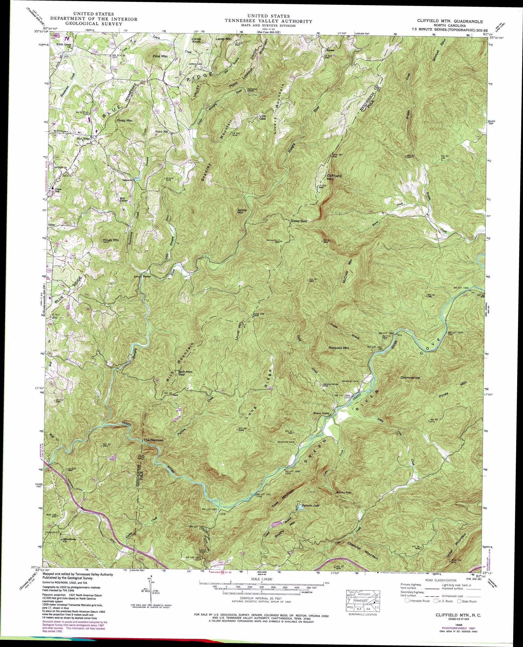
Cliffield Mountain Topo Map North Carolina
To zoom in, hover over the map of Cliffield Mountain
USGS Topo Quad 35082c3 - 1:24,000 scale
| Topo Map Name: | Cliffield Mountain |
| USGS Topo Quad ID: | 35082c3 |
| Print Size: | ca. 21 1/4" wide x 27" high |
| Southeast Coordinates: | 35.25° N latitude / 82.25° W longitude |
| Map Center Coordinates: | 35.3125° N latitude / 82.3125° W longitude |
| U.S. State: | NC |
| Filename: | o35082c3.jpg |
| Download Map JPG Image: | Cliffield Mountain topo map 1:24,000 scale |
| Map Type: | Topographic |
| Topo Series: | 7.5´ |
| Map Scale: | 1:24,000 |
| Source of Map Images: | United States Geological Survey (USGS) |
| Alternate Map Versions: |
Fishtop NC 1935 Download PDF Buy paper map Cliffield Mtn NC 1946, updated 1957 Download PDF Buy paper map Cliffield Mtn NC 1946, updated 1967 Download PDF Buy paper map Cliffield Mtn NC 1946, updated 1976 Download PDF Buy paper map Cliffield Mtn. NC 1946, updated 1991 Download PDF Buy paper map Cliffield Mtn NC 1947, updated 1947 Download PDF Buy paper map Cliffield Mtn. NC 1997, updated 2001 Download PDF Buy paper map Cliffield Mountain NC 2010 Download PDF Buy paper map Cliffield Mountain NC 2013 Download PDF Buy paper map Cliffield Mountain NC 2016 Download PDF Buy paper map |
1:24,000 Topo Quads surrounding Cliffield Mountain
Asheville |
Oteen |
Black Mountain |
Moffitt Hill |
Sugar Hill |
Skyland |
Fruitland |
Bat Cave |
Lake Lure |
Shingle Hollow |
Horse Shoe |
Hendersonville |
Cliffield Mountain |
Mill Spring |
Pea Ridge |
Standingstone Mountain |
Zirconia |
Saluda |
Landrum |
Fingerville West |
Cleveland |
Slater |
Tigerville |
Campobello |
Inman |
> Back to 35082a1 at 1:100,000 scale
> Back to 35082a1 at 1:250,000 scale
> Back to U.S. Topo Maps home
Cliffield Mountain topo map: Gazetteer
Cliffield Mountain: Dams
Larry Ball Dam elevation 668m 2191′Palmetto Lake Lower Dam elevation 494m 1620′
Palmetto Lake Upper Dam elevation 532m 1745′
Pegram Lake Dam elevation 601m 1971′
Cliffield Mountain: Falls
Bradley Falls elevation 449m 1473′Cliffield Mountain: Gaps
Deep Gap elevation 772m 2532′Low Gap elevation 795m 2608′
Rich Mountain Gap elevation 737m 2417′
The Narrows elevation 435m 1427′
Cliffield Mountain: Populated Places
Baxter elevation 554m 1817′Blue Ridge elevation 688m 2257′
Copper Ford elevation 708m 2322′
Horace elevation 846m 2775′
Mill Corner elevation 645m 2116′
Mount Valley elevation 312m 1023′
Saconon elevation 608m 1994′
Union Hill elevation 677m 2221′
Cliffield Mountain: Reservoirs
Larry Ball Lake elevation 668m 2191′Palmetto Lake elevation 494m 1620′
Palmetto Lake elevation 532m 1745′
Pegram Lake elevation 601m 1971′
Cliffield Mountain: Ridges
Long Ridge elevation 699m 2293′Wildcat Spur elevation 957m 3139′
Cliffield Mountain: Streams
Big Branch elevation 669m 2194′Byers Creek elevation 661m 2168′
Camp Creek elevation 358m 1174′
Casey Branch elevation 371m 1217′
Cove Creek elevation 306m 1003′
Gadd Creek elevation 305m 1000′
Harm Creek elevation 311m 1020′
Hungry River elevation 474m 1555′
Laurel Branch elevation 296m 971′
Little Cove Creek elevation 304m 997′
Little Hungry River elevation 574m 1883′
Mill Creek elevation 487m 1597′
Pulliam Creek elevation 390m 1279′
Saconon Creek elevation 616m 2020′
Tumblebug Creek elevation 559m 1833′
Cliffield Mountain: Summits
Annie Mountain elevation 768m 2519′Bradley Mountain elevation 837m 2746′
Brushy Mountain elevation 645m 2116′
Chestnut Mountain elevation 624m 2047′
Chimneytop elevation 581m 1906′
Cliffield Mountain elevation 913m 2995′
Cove Mountain elevation 637m 2089′
Jones Knob elevation 728m 2388′
Kings Mountain elevation 751m 2463′
Lamb Mountain elevation 792m 2598′
Laurel Mountain elevation 844m 2769′
Livert Mountain elevation 850m 2788′
McCraw Mountain elevation 741m 2431′
Miller Mountain elevation 778m 2552′
Pilot Mountain elevation 771m 2529′
Piney Mountain elevation 564m 1850′
Piney Mountain elevation 747m 2450′
Raccoon Mountain elevation 659m 2162′
Rich Mountain elevation 775m 2542′
Cliffield Mountain: Valleys
Green River Cove elevation 284m 931′Cliffield Mountain digital topo map on disk
Buy this Cliffield Mountain topo map showing relief, roads, GPS coordinates and other geographical features, as a high-resolution digital map file on DVD:
South Carolina, Western North Carolina & Northeastern Georgia
Buy digital topo maps: South Carolina, Western North Carolina & Northeastern Georgia