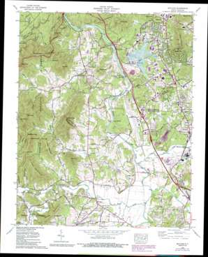
Skyland Topo Map North Carolina
To zoom in, hover over the map of Skyland
USGS Topo Quad 35082d5 - 1:24,000 scale
| Topo Map Name: | Skyland |
| USGS Topo Quad ID: | 35082d5 |
| Print Size: | ca. 21 1/4" wide x 27" high |
| Southeast Coordinates: | 35.375° N latitude / 82.5° W longitude |
| Map Center Coordinates: | 35.4375° N latitude / 82.5625° W longitude |
| U.S. State: | NC |
| Filename: | o35082d5.jpg |
| Download Map JPG Image: | Skyland topo map 1:24,000 scale |
| Map Type: | Topographic |
| Topo Series: | 7.5´ |
| Map Scale: | 1:24,000 |
| Source of Map Images: | United States Geological Survey (USGS) |
| Alternate Map Versions: |
Skyland NC 1936 Download PDF Buy paper map Skyland NC 1942, updated 1956 Download PDF Buy paper map Skyland NC 1942, updated 1965 Download PDF Buy paper map Skyland NC 1943 Download PDF Buy paper map Skyland NC 1965, updated 1966 Download PDF Buy paper map Skyland NC 1965, updated 1972 Download PDF Buy paper map Skyland NC 1965, updated 1979 Download PDF Buy paper map Skyland NC 1965, updated 1986 Download PDF Buy paper map Skyland NC 1965, updated 1991 Download PDF Buy paper map Skyland NC 1965, updated 1991 Download PDF Buy paper map Skyland NC 2011 Download PDF Buy paper map Skyland NC 2013 Download PDF Buy paper map Skyland NC 2016 Download PDF Buy paper map |
| FStopo: | US Forest Service topo Skyland is available: Download FStopo PDF Download FStopo TIF |
1:24,000 Topo Quads surrounding Skyland
> Back to 35082a1 at 1:100,000 scale
> Back to 35082a1 at 1:250,000 scale
> Back to U.S. Topo Maps home
Skyland topo map: Gazetteer
Skyland: Airports
Asheville Municipal Airport elevation 652m 2139′Ritter Airpark elevation 658m 2158′
Skyland: Bars
Buck Shoals elevation 620m 2034′Long Shoals elevation 616m 2020′
Skyland: Bends
Sandy Bottom elevation 614m 2014′Skyland: Bridges
Butler Bridge elevation 622m 2040′Fanning Bridge elevation 621m 2037′
Glenn Bridge elevation 619m 2030′
Long Shoals Bridge elevation 616m 2020′
Mills River Bridge elevation 630m 2066′
Skyland: Dams
Holloman Pond Dam elevation 649m 2129′Lake Powhatan Dam elevation 657m 2155′
NC Noname Two-Hundred Sixty Dam elevation 658m 2158′
Taylor Dam elevation 818m 2683′
Skyland: Gaps
Allen Gap elevation 820m 2690′Ball Gap elevation 776m 2545′
Reynolds Gap elevation 898m 2946′
Soapstone Gap elevation 862m 2828′
Terry Gap elevation 739m 2424′
Skyland: Populated Places
Arden elevation 676m 2217′Avery Creek elevation 670m 2198′
Brickton elevation 639m 2096′
Busbee elevation 695m 2280′
Fletcher elevation 645m 2116′
Midway elevation 677m 2221′
Mills River elevation 639m 2096′
Mountain View elevation 728m 2388′
Naples elevation 635m 2083′
Oak Forest elevation 696m 2283′
Oak Hill Court elevation 639m 2096′
Oak Park elevation 680m 2230′
Royal Pines elevation 693m 2273′
Skyland elevation 684m 2244′
West Haven elevation 661m 2168′
Skyland: Post Offices
Busbee Post Office (historical) elevation 695m 2280′Skyland: Reservoirs
Camp Deer Lake elevation 650m 2132′Capps Lake elevation 653m 2142′
Dubose Lake elevation 652m 2139′
Frady Lake elevation 653m 2142′
Hollaman Lake elevation 637m 2089′
Holloman Pond elevation 649m 2129′
Innisfree Lake elevation 631m 2070′
Lake Coma elevation 628m 2060′
Lake Julian elevation 658m 2158′
Lake Powhatan elevation 657m 2155′
Roberts Lake elevation 639m 2096′
Skyland: Ridges
Shut-in Ridge elevation 781m 2562′Skyland: Streams
Ashley Branch elevation 612m 2007′Avery Creek elevation 620m 2034′
Brandy Branch elevation 627m 2057′
Cane Creek elevation 623m 2043′
Clayton Creek elevation 612m 2007′
Cushion Branch elevation 631m 2070′
Ducker Creek elevation 615m 2017′
Foster Creek elevation 635m 2083′
Higgins Branch elevation 629m 2063′
Kimsey Creek elevation 622m 2040′
Ledford Branch elevation 645m 2116′
Line Creek elevation 620m 2034′
McCall Branch elevation 648m 2125′
McDowell Creek elevation 621m 2037′
Mills River elevation 623m 2043′
Mud Creek elevation 623m 2043′
Newman Branch elevation 677m 2221′
North Fork Mills River elevation 645m 2116′
Orton Branch elevation 612m 2007′
Soapstone Branch elevation 681m 2234′
South Fork Mills River elevation 645m 2116′
South Fork Mills River elevation 645m 2116′
Spain Branch elevation 664m 2178′
Wesley Creek elevation 619m 2030′
Wolf Branch elevation 637m 2089′
Skyland: Summits
Ball Mountain elevation 932m 3057′Blake Mountain elevation 760m 2493′
Britton Mountain elevation 768m 2519′
Brown Mountain elevation 912m 2992′
Bryson Mountain elevation 888m 2913′
Caney Mountain elevation 870m 2854′
Chestnut Top elevation 933m 3061′
Crescent Hill elevation 752m 2467′
Double Knob elevation 1030m 3379′
Ducker Mountain elevation 799m 2621′
Frady Mountain elevation 768m 2519′
Glenn Bald elevation 821m 2693′
Hogback Knob elevation 935m 3067′
Lance Mountain elevation 915m 3001′
Mills Knob elevation 840m 2755′
West Knob elevation 1003m 3290′
Skyland: Tunnels
Grassy Knob Tunnel elevation 920m 3018′Skyland: Valleys
Mullinax Cove elevation 648m 2125′Poplar Cove elevation 634m 2080′
Reed Cove elevation 714m 2342′
Whitaker Cove elevation 648m 2125′
Skyland digital topo map on disk
Buy this Skyland topo map showing relief, roads, GPS coordinates and other geographical features, as a high-resolution digital map file on DVD:
South Carolina, Western North Carolina & Northeastern Georgia
Buy digital topo maps: South Carolina, Western North Carolina & Northeastern Georgia


