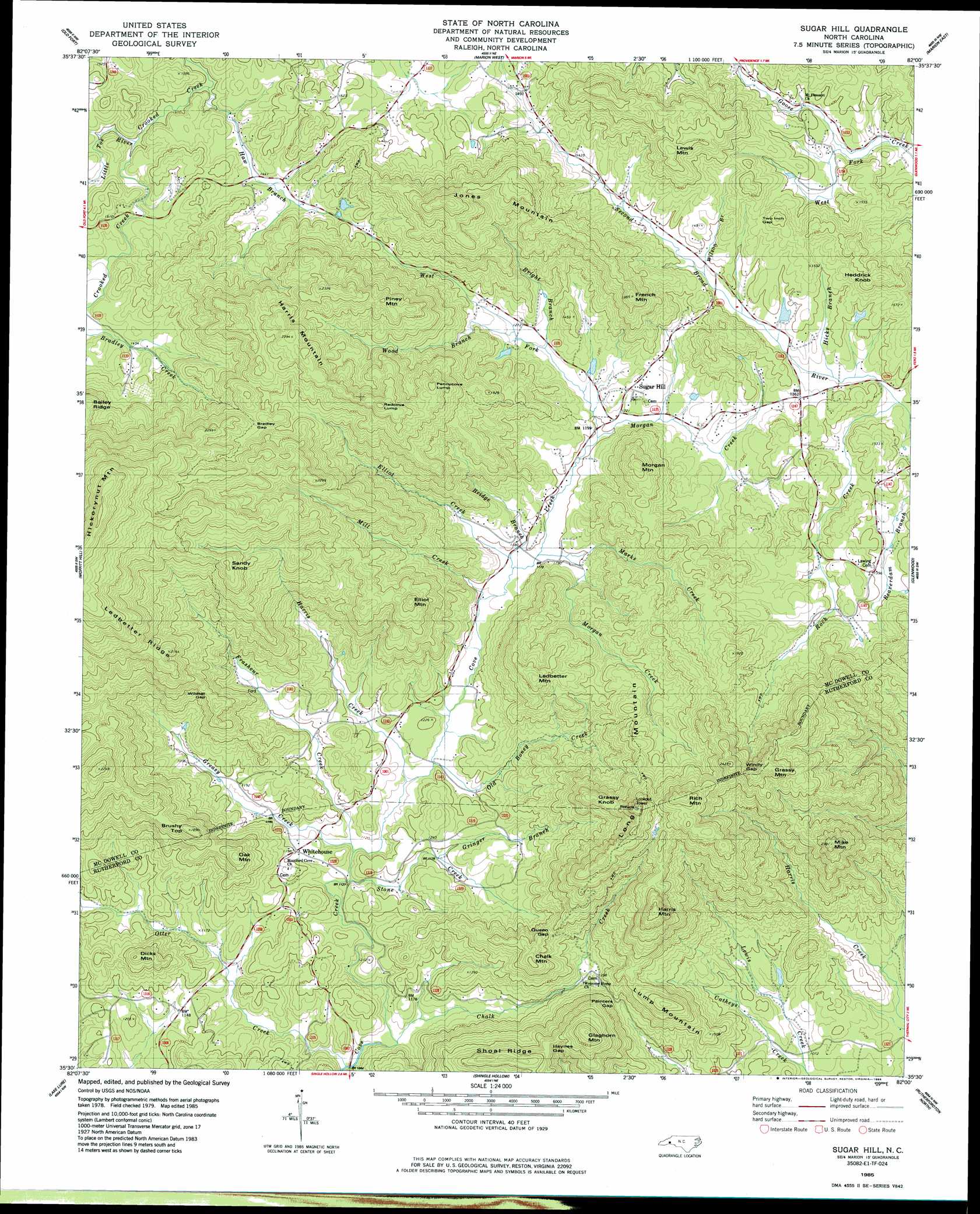
Sugar Hill Topo Map North Carolina
To zoom in, hover over the map of Sugar Hill
USGS Topo Quad 35082e1 - 1:24,000 scale
| Topo Map Name: | Sugar Hill |
| USGS Topo Quad ID: | 35082e1 |
| Print Size: | ca. 21 1/4" wide x 27" high |
| Southeast Coordinates: | 35.5° N latitude / 82° W longitude |
| Map Center Coordinates: | 35.5625° N latitude / 82.0625° W longitude |
| U.S. State: | NC |
| Filename: | o35082e1.jpg |
| Download Map JPG Image: | Sugar Hill topo map 1:24,000 scale |
| Map Type: | Topographic |
| Topo Series: | 7.5´ |
| Map Scale: | 1:24,000 |
| Source of Map Images: | United States Geological Survey (USGS) |
| Alternate Map Versions: |
Sugar Hill NC 1985, updated 1986 Download PDF Buy paper map Sugar Hill NC 2010 Download PDF Buy paper map Sugar Hill NC 2013 Download PDF Buy paper map Sugar Hill NC 2016 Download PDF Buy paper map |
1:24,000 Topo Quads surrounding Sugar Hill
Mount Mitchell |
Celo |
Little Switzerland |
Ashford |
Oak Hill |
Montreat |
Old Fort |
Marion West |
Marion East |
Glen Alpine |
Black Mountain |
Moffitt Hill |
Sugar Hill |
Glenwood |
Dysartsville |
Bat Cave |
Lake Lure |
Shingle Hollow |
Rutherfordton North |
Sunshine |
Cliffield Mountain |
Mill Spring |
Pea Ridge |
Rutherfordton South |
Forest City |
> Back to 35082e1 at 1:100,000 scale
> Back to 35082a1 at 1:250,000 scale
> Back to U.S. Topo Maps home
Sugar Hill topo map: Gazetteer
Sugar Hill: Gaps
Bradley Gap elevation 636m 2086′Haynes Gap elevation 509m 1669′
Painters Gap elevation 425m 1394′
Queen Gap elevation 419m 1374′
Two Inch Gap elevation 446m 1463′
Wildcat Gap elevation 504m 1653′
Windy Gap elevation 667m 2188′
Sugar Hill: Populated Places
Otter Creek (historical) elevation 365m 1197′Sugar Hill elevation 388m 1272′
Whitehouse elevation 365m 1197′
Sugar Hill: Ridges
Ledbetter Ridge elevation 616m 2020′Shoal Ridge elevation 586m 1922′
Sugar Hill: Streams
Bridge Branch elevation 355m 1164′Bright Branch elevation 376m 1233′
Chalk Creek elevation 318m 1043′
Elliot Creek elevation 355m 1164′
Frasheur Creek elevation 339m 1112′
Greasy Creek elevation 341m 1118′
Gringer Branch elevation 359m 1177′
Harris Creek elevation 344m 1128′
Haw Branch elevation 417m 1368′
Hicks Branch elevation 395m 1295′
Lewis Creek elevation 320m 1049′
Little Toe River elevation 421m 1381′
Marks Creek elevation 359m 1177′
Mill Creek elevation 351m 1151′
Morgan Creek elevation 356m 1167′
Morgan Creek elevation 364m 1194′
Old Boney Creek elevation 346m 1135′
Otter Creek elevation 316m 1036′
Rock Creek elevation 391m 1282′
Stone Creek elevation 339m 1112′
West Fork Cove Creek elevation 364m 1194′
West Fork Goose Creek elevation 401m 1315′
Wilson Branch elevation 411m 1348′
Wood Branch elevation 383m 1256′
Sugar Hill: Summits
Brushy Top elevation 563m 1847′Chalk Mountain elevation 557m 1827′
Dicks Mountain elevation 481m 1578′
Elliot Mountain elevation 609m 1998′
French Mountain elevation 593m 1945′
Glaghorn Mountain elevation 641m 2103′
Grassy Knob elevation 664m 2178′
Grassy Mountain elevation 724m 2375′
Harris Mountain elevation 748m 2454′
Harris Mountain elevation 737m 2417′
Heddrick Knob elevation 521m 1709′
Jones Mountain elevation 711m 2332′
Ledbetter Mountain elevation 584m 1916′
Lewis Mountain elevation 582m 1909′
Long Mountain elevation 588m 1929′
Lump Mountain elevation 547m 1794′
Mike Mountain elevation 689m 2260′
Morgan Mountain elevation 576m 1889′
Oak Mountain elevation 523m 1715′
Pennycove Lump elevation 673m 2208′
Piney Mountain elevation 654m 2145′
Pinnacle Mountain elevation 760m 2493′
Redcove Lump elevation 726m 2381′
Rich Mountain elevation 758m 2486′
Sandy Knob elevation 717m 2352′
Sugar Hill digital topo map on disk
Buy this Sugar Hill topo map showing relief, roads, GPS coordinates and other geographical features, as a high-resolution digital map file on DVD:
South Carolina, Western North Carolina & Northeastern Georgia
Buy digital topo maps: South Carolina, Western North Carolina & Northeastern Georgia