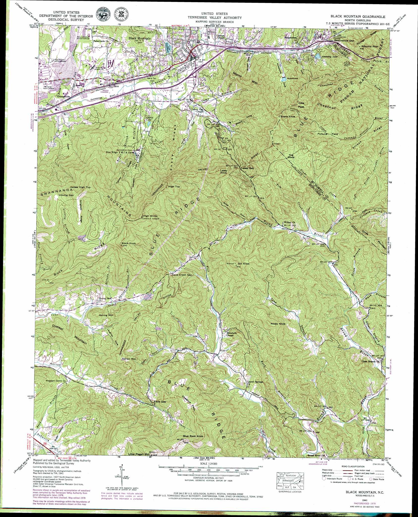
Black Mountain Topo Map North Carolina
To zoom in, hover over the map of Black Mountain
USGS Topo Quad 35082e3 - 1:24,000 scale
| Topo Map Name: | Black Mountain |
| USGS Topo Quad ID: | 35082e3 |
| Print Size: | ca. 21 1/4" wide x 27" high |
| Southeast Coordinates: | 35.5° N latitude / 82.25° W longitude |
| Map Center Coordinates: | 35.5625° N latitude / 82.3125° W longitude |
| U.S. State: | NC |
| Filename: | o35082e3.jpg |
| Download Map JPG Image: | Black Mountain topo map 1:24,000 scale |
| Map Type: | Topographic |
| Topo Series: | 7.5´ |
| Map Scale: | 1:24,000 |
| Source of Map Images: | United States Geological Survey (USGS) |
| Alternate Map Versions: |
Black Mountain NC 1935 Download PDF Buy paper map Black Mountain NC 1941, updated 1957 Download PDF Buy paper map Black Mountain NC 1941, updated 1965 Download PDF Buy paper map Black Mountain NC 1941, updated 1973 Download PDF Buy paper map Black Mountain NC 1941, updated 1979 Download PDF Buy paper map Black Mountain NC 1941, updated 1989 Download PDF Buy paper map Black Mountain NC 1943 Download PDF Buy paper map Black Mountain NC 1994, updated 1998 Download PDF Buy paper map Black Mountain NC 2011 Download PDF Buy paper map Black Mountain NC 2013 Download PDF Buy paper map Black Mountain NC 2016 Download PDF Buy paper map |
| FStopo: | US Forest Service topo Black Mountain is available: Download FStopo PDF Download FStopo TIF |
1:24,000 Topo Quads surrounding Black Mountain
Mars Hill |
Barnardsville |
Mount Mitchell |
Celo |
Little Switzerland |
Weaverville |
Craggy Pinnacle |
Montreat |
Old Fort |
Marion West |
Asheville |
Oteen |
Black Mountain |
Moffitt Hill |
Sugar Hill |
Skyland |
Fruitland |
Bat Cave |
Lake Lure |
Shingle Hollow |
Horse Shoe |
Hendersonville |
Cliffield Mountain |
Mill Spring |
Pea Ridge |
> Back to 35082e1 at 1:100,000 scale
> Back to 35082a1 at 1:250,000 scale
> Back to U.S. Topo Maps home
Black Mountain topo map: Gazetteer
Black Mountain: Basins
Fortune Field elevation 807m 2647′The Glade elevation 941m 3087′
Black Mountain: Dams
Black Mountain Reservoir Dam elevation 802m 2631′Camp Ridgecrest Dam elevation 796m 2611′
Echo Lake Dam elevation 813m 2667′
Lake Tomahawk Dam elevation 714m 2342′
Little Pisgah Camp Dam elevation 821m 2693′
Ponderosa Lake Dam elevation 1117m 3664′
Black Mountain: Flats
Chestnut Flats elevation 1074m 3523′Black Mountain: Gaps
Cane Creek Gap elevation 903m 2962′Eads Gap elevation 882m 2893′
Lakey Gap elevation 926m 3038′
Licklog Gap elevation 1165m 3822′
Swannanoa Gap elevation 819m 2687′
Black Mountain: Populated Places
Black Mountain elevation 731m 2398′Grovestone elevation 689m 2260′
Ridgecrest elevation 772m 2532′
Black Mountain: Reservoirs
Assembly Lake elevation 791m 2595′Black Mountain Reservoir elevation 802m 2631′
Camp Ridgecrest Lake elevation 796m 2611′
Echo Lake elevation 813m 2667′
Lake Evens elevation 821m 2693′
Lake Tomahawk elevation 714m 2342′
Laurel Lake elevation 735m 2411′
Ponderosa Lake elevation 1117m 3664′
Black Mountain: Ridges
Allison Ridge elevation 819m 2687′Buck Ridge elevation 1129m 3704′
Chestnut Ridge elevation 1019m 3343′
Isinglass Ridge elevation 1242m 4074′
Sheep Ridge elevation 920m 3018′
Turkey Ridge elevation 994m 3261′
Black Mountain: Streams
Briar Branch elevation 720m 2362′Camp Branch elevation 704m 2309′
Clear Branch elevation 667m 2188′
Duck Branch elevation 705m 2312′
Ellison Branch elevation 784m 2572′
Flat Branch elevation 811m 2660′
Flat Creek elevation 719m 2358′
Glade Creek elevation 767m 2516′
Grice Branch elevation 709m 2326′
Licklog Branch elevation 1043m 3421′
North Fork Swannanoa River elevation 678m 2224′
Reed Branch elevation 689m 2260′
Rock Creek elevation 637m 2089′
Rush Branch elevation 621m 2037′
Sand Branch elevation 620m 2034′
Spring Mountain Branch elevation 797m 2614′
Stepp Branch elevation 676m 2217′
Tom Creek elevation 776m 2545′
Tomahawk Branch elevation 695m 2280′
Wolfpit Branch elevation 692m 2270′
Black Mountain: Summits
Black Knob elevation 1286m 4219′Blue Rock Mountain elevation 1164m 3818′
Cross Mountain elevation 1045m 3428′
Dill Knob elevation 1151m 3776′
Dyeleaf Mountain elevation 918m 3011′
Evans Knob elevation 1058m 3471′
Garren Mountain elevation 1018m 3339′
High Top elevation 1274m 4179′
High Windy elevation 1318m 4324′
Jesses High Top elevation 1327m 4353′
Jobs Peak elevation 1009m 3310′
Kitsuma Peak elevation 965m 3166′
Lakey Knob elevation 1141m 3743′
Little Pisgah Mountain elevation 1340m 4396′
Miami Mountain elevation 947m 3106′
Rocky Knob elevation 1053m 3454′
Spring Mountain elevation 883m 2896′
Black Mountain: Tunnels
Swannanoa Tunnel elevation 808m 2650′Black Mountain: Valleys
Brittin Cove elevation 714m 2342′Burgin Cove elevation 739m 2424′
Cabin Cove elevation 760m 2493′
Dunsmore Cove elevation 752m 2467′
Glen Cove elevation 762m 2500′
Johnson Cove elevation 692m 2270′
Laughter Cove elevation 748m 2454′
Little Cove elevation 676m 2217′
Lynch Cove elevation 712m 2335′
McCoy Cove elevation 729m 2391′
Miller Cove elevation 831m 2726′
Sugar Hollow elevation 695m 2280′
Black Mountain digital topo map on disk
Buy this Black Mountain topo map showing relief, roads, GPS coordinates and other geographical features, as a high-resolution digital map file on DVD:
South Carolina, Western North Carolina & Northeastern Georgia
Buy digital topo maps: South Carolina, Western North Carolina & Northeastern Georgia