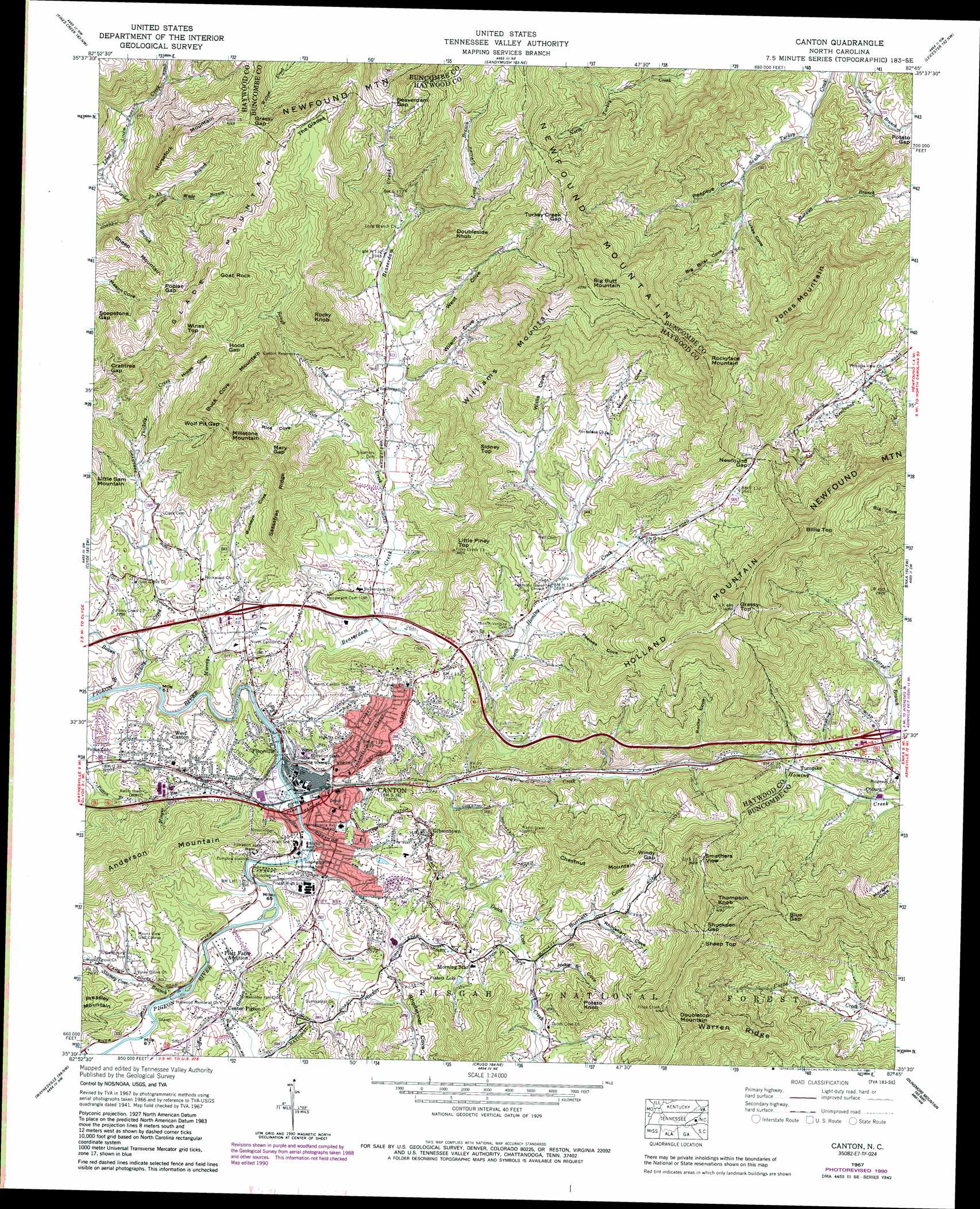
Canton Topo Map North Carolina
To zoom in, hover over the map of Canton
USGS Topo Quad 35082e7 - 1:24,000 scale
| Topo Map Name: | Canton |
| USGS Topo Quad ID: | 35082e7 |
| Print Size: | ca. 21 1/4" wide x 27" high |
| Southeast Coordinates: | 35.5° N latitude / 82.75° W longitude |
| Map Center Coordinates: | 35.5625° N latitude / 82.8125° W longitude |
| U.S. State: | NC |
| Filename: | o35082e7.jpg |
| Download Map JPG Image: | Canton topo map 1:24,000 scale |
| Map Type: | Topographic |
| Topo Series: | 7.5´ |
| Map Scale: | 1:24,000 |
| Source of Map Images: | United States Geological Survey (USGS) |
| Alternate Map Versions: |
Canton NC 1935 Download PDF Buy paper map Canton NC 1941, updated 1956 Download PDF Buy paper map Canton NC 1942 Download PDF Buy paper map Canton NC 1942 Download PDF Buy paper map Canton NC 1967, updated 1970 Download PDF Buy paper map Canton NC 1967, updated 1980 Download PDF Buy paper map Canton NC 1967, updated 1988 Download PDF Buy paper map Canton NC 1967, updated 1991 Download PDF Buy paper map Canton NC 2011 Download PDF Buy paper map Canton NC 2013 Download PDF Buy paper map Canton NC 2016 Download PDF Buy paper map |
| FStopo: | US Forest Service topo Canton is available: Download FStopo PDF Download FStopo TIF |
1:24,000 Topo Quads surrounding Canton
Waterville |
Lemon Gap |
Spring Creek |
Marshall |
Mars Hill |
Cove Creek Gap |
Fines Creek |
Sandymush |
Leicester |
Weaverville |
Dellwood |
Clyde |
Canton |
Enka |
Asheville |
Hazelwood |
Waynesville |
Cruso |
Dunsmore Mountain |
Skyland |
Tuckasegee |
Sam Knob |
Shining Rock |
Pisgah Forest |
Horse Shoe |
> Back to 35082e1 at 1:100,000 scale
> Back to 35082a1 at 1:250,000 scale
> Back to U.S. Topo Maps home
Canton topo map: Gazetteer
Canton: Gaps
Beaverdam Gap elevation 1147m 3763′Blue Gap elevation 1012m 3320′
Crabtree Gap elevation 1122m 3681′
Grassy Gap elevation 1238m 4061′
Hood Gap elevation 1162m 3812′
Mary Gap elevation 1047m 3435′
Newfound Gap elevation 925m 3034′
Poplar Gap elevation 1170m 3838′
Shuckpen Gap elevation 1200m 3937′
Turkey Creek Gap elevation 1206m 3956′
Windy Gap elevation 924m 3031′
Wolf Pit Gap elevation 1190m 3904′
Canton: Populated Places
Canton elevation 797m 2614′Center Pigeon elevation 809m 2654′
Coburn elevation 698m 2290′
Fibreville elevation 810m 2657′
Gibsontown elevation 846m 2775′
Morning Star elevation 859m 2818′
Plott Farm Addition elevation 801m 2627′
Turnpike elevation 693m 2273′
West Canton elevation 831m 2726′
Canton: Reservoirs
Canton Reservoir elevation 977m 3205′Fishers Lake elevation 853m 2798′
Canton: Ridges
Sassafras Ridge elevation 988m 3241′Warren Ridge elevation 949m 3113′
Canton: Streams
Beaverdam Creek elevation 782m 2565′Bowen Branch elevation 772m 2532′
Coffee Branch elevation 801m 2627′
Dutch Cove Creek elevation 731m 2398′
Garden Creek elevation 789m 2588′
Jo Ab Branch elevation 963m 3159′
Long Branch elevation 918m 3011′
Mingus Branch elevation 782m 2565′
Murray Branch elevation 777m 2549′
North Hominy Creek elevation 725m 2378′
Rice Cove Creek elevation 815m 2673′
Rough Creek elevation 830m 2723′
Stamey Cove Branch elevation 793m 2601′
Thickety Creek elevation 780m 2559′
Wade Branch elevation 1022m 3353′
Canton: Summits
Big Butt Mountain elevation 1453m 4767′Billie Top elevation 1224m 4015′
Buck Cove Mountain elevation 1330m 4363′
Chestnut Mountain elevation 1043m 3421′
Doubleside Knob elevation 1226m 4022′
Doubletop Mountain elevation 1258m 4127′
Glade Mountain elevation 1271m 4169′
Goat Rock elevation 1348m 4422′
Grassy Top elevation 1270m 4166′
Holland Mountain elevation 1262m 4140′
Horsefork Mountain elevation 1236m 4055′
Jones Mountain elevation 1237m 4058′
Little Piney Top elevation 1033m 3389′
Millstone Mountain elevation 1236m 4055′
Potato Knob elevation 1018m 3339′
Rocky Knob elevation 1264m 4146′
Rockyface Mountain elevation 1393m 4570′
Sheep Mountain elevation 1153m 3782′
Sheep Top elevation 1220m 4002′
Sidney Top elevation 1029m 3375′
Smathers View elevation 1115m 3658′
The Glades elevation 1322m 4337′
Thompson Knob elevation 1265m 4150′
Williams Mountain elevation 1365m 4478′
Wines Top elevation 1321m 4333′
Canton: Valleys
Big Briar Cove elevation 846m 2775′Buckeye Cove elevation 800m 2624′
Burnett Cove elevation 816m 2677′
Hipps Cove elevation 974m 3195′
Jodie B Cove elevation 818m 2683′
Lukes Cove elevation 806m 2644′
Peepeye Cove elevation 781m 2562′
Peewee Cove elevation 804m 2637′
Rhinehart Cove elevation 846m 2775′
Rhodarmer Cove elevation 806m 2644′
Rice Cove elevation 848m 2782′
Rocky Cove elevation 701m 2299′
Sorrels Cove elevation 772m 2532′
Stamey Cove elevation 793m 2601′
West Cove elevation 853m 2798′
Willis Cove elevation 811m 2660′
Wilson Cove elevation 839m 2752′
Worley Cove elevation 821m 2693′
Canton digital topo map on disk
Buy this Canton topo map showing relief, roads, GPS coordinates and other geographical features, as a high-resolution digital map file on DVD:
South Carolina, Western North Carolina & Northeastern Georgia
Buy digital topo maps: South Carolina, Western North Carolina & Northeastern Georgia