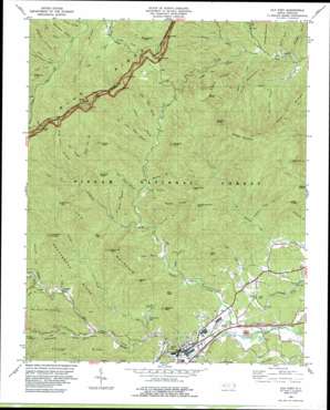
Old Fort Topo Map North Carolina
To zoom in, hover over the map of Old Fort
USGS Topo Quad 35082f2 - 1:24,000 scale
| Topo Map Name: | Old Fort |
| USGS Topo Quad ID: | 35082f2 |
| Print Size: | ca. 21 1/4" wide x 27" high |
| Southeast Coordinates: | 35.625° N latitude / 82.125° W longitude |
| Map Center Coordinates: | 35.6875° N latitude / 82.1875° W longitude |
| U.S. State: | NC |
| Filename: | o35082f2.jpg |
| Download Map JPG Image: | Old Fort topo map 1:24,000 scale |
| Map Type: | Topographic |
| Topo Series: | 7.5´ |
| Map Scale: | 1:24,000 |
| Source of Map Images: | United States Geological Survey (USGS) |
| Alternate Map Versions: |
Parts Of Old Fort and Montreat NC 1934 Download PDF Buy paper map Old Fort NC 1994, updated 1998 Download PDF Buy paper map Old Fort NC 2011 Download PDF Buy paper map Old Fort NC 2013 Download PDF Buy paper map Old Fort NC 2016 Download PDF Buy paper map |
| FStopo: | US Forest Service topo Old Fort is available: Download FStopo PDF Download FStopo TIF |
1:24,000 Topo Quads surrounding Old Fort
> Back to 35082e1 at 1:100,000 scale
> Back to 35082a1 at 1:250,000 scale
> Back to U.S. Topo Maps home
Old Fort topo map: Gazetteer
Old Fort: Airports
Neals Creek Heliport elevation 928m 3044′Old Fort: Cliffs
Point Lookout elevation 654m 2145′Old Fort: Dams
Camp Grier Dam elevation 511m 1676′Old Fort: Gaps
Big Laurel Gap elevation 991m 3251′Deep Gap elevation 1308m 4291′
Flinty Gap elevation 1438m 4717′
Horse Trail Gap elevation 1165m 3822′
Lead Mine Gap elevation 995m 3264′
Salt Gap elevation 556m 1824′
Star Gap elevation 709m 2326′
Old Fort: Parks
Old Fort Picnic Area elevation 502m 1646′Old Fort: Populated Places
Dendron elevation 519m 1702′Old Fort elevation 438m 1437′
Sunnyvale elevation 519m 1702′
Old Fort: Reservoirs
Camp Grier Lake elevation 474m 1555′Old Fort: Ridges
Big Fork Ridge elevation 1206m 3956′Black Ridge elevation 1421m 4662′
Flynn Ridge elevation 1084m 3556′
Grassy Ridge elevation 944m 3097′
Heartbreak Ridge elevation 695m 2280′
Lost Cove Ridge elevation 1213m 3979′
Moses Ridge elevation 814m 2670′
Poplar Ridge elevation 1041m 3415′
Sams Ridge elevation 888m 2913′
Whiteside Ridge elevation 1187m 3894′
Youngs Ridge elevation 742m 2434′
Old Fort: Springs
Andrews Geyser elevation 627m 2057′Old Fort: Streams
Bear Cave Branch elevation 546m 1791′Bear Drive Branch elevation 756m 2480′
Big Lost Cove Creek elevation 906m 2972′
Brevard Creek elevation 410m 1345′
Brushy Branch elevation 521m 1709′
Burgins Fork elevation 520m 1706′
Camp Creek elevation 941m 3087′
Camp Rock Branch elevation 651m 2135′
Cave Creek elevation 458m 1502′
Chute Branch elevation 737m 2417′
Curtis Creek elevation 416m 1364′
Deep Branch elevation 471m 1545′
Hickory Branch elevation 560m 1837′
Horse Branch elevation 548m 1797′
Jarrett Creek elevation 459m 1505′
Laurel Fork Creek elevation 494m 1620′
Laurel Log Branch elevation 880m 2887′
Left Prong Newberry Creek elevation 886m 2906′
Licklog Branch elevation 688m 2257′
Licklog Creek elevation 551m 1807′
Locust Creek elevation 505m 1656′
Long Branch elevation 560m 1837′
Long Branch elevation 561m 1840′
Lower Creek elevation 967m 3172′
Neals Creek elevation 929m 3047′
Newberry Creek elevation 505m 1656′
Paddys Branch elevation 458m 1502′
Parris Creek elevation 577m 1893′
Pritchard Creek elevation 569m 1866′
Right Prong South Toe River elevation 1051m 3448′
Sams Creek elevation 551m 1807′
Setrock Creek elevation 921m 3021′
Singecat Branch elevation 592m 1942′
Slick Falls Branch elevation 554m 1817′
Straight Branch elevation 509m 1669′
Sugar Cave Creek elevation 568m 1863′
Swannanoa Creek elevation 489m 1604′
Tantrough Branch elevation 497m 1630′
Upper Creek elevation 985m 3231′
Walnut Cove Creek elevation 639m 2096′
Old Fort: Summits
Bergen Mountain elevation 685m 2247′Bernard Mountain elevation 800m 2624′
Big Laurel Mountain elevation 1258m 4127′
Buckeye Knob elevation 971m 3185′
Chestnut Knob elevation 1223m 4012′
Chestnutwood Mountain elevation 1109m 3638′
Green Knob elevation 1538m 5045′
Iron Mountain elevation 1089m 3572′
Jerdon Mountain elevation 833m 2732′
Laurel Knob elevation 1300m 4265′
Licklog Knob elevation 972m 3188′
Long Ridge elevation 949m 3113′
Lost Cove Knob elevation 884m 2900′
Mackey Mountain elevation 1199m 3933′
Narrows Knob elevation 1032m 3385′
Pine Mountain elevation 802m 2631′
Piney Mountain elevation 787m 2582′
Rocky Mountain elevation 1089m 3572′
Sams Knob elevation 998m 3274′
Snooks Nose elevation 1136m 3727′
Old Fort digital topo map on disk
Buy this Old Fort topo map showing relief, roads, GPS coordinates and other geographical features, as a high-resolution digital map file on DVD:
South Carolina, Western North Carolina & Northeastern Georgia
Buy digital topo maps: South Carolina, Western North Carolina & Northeastern Georgia


