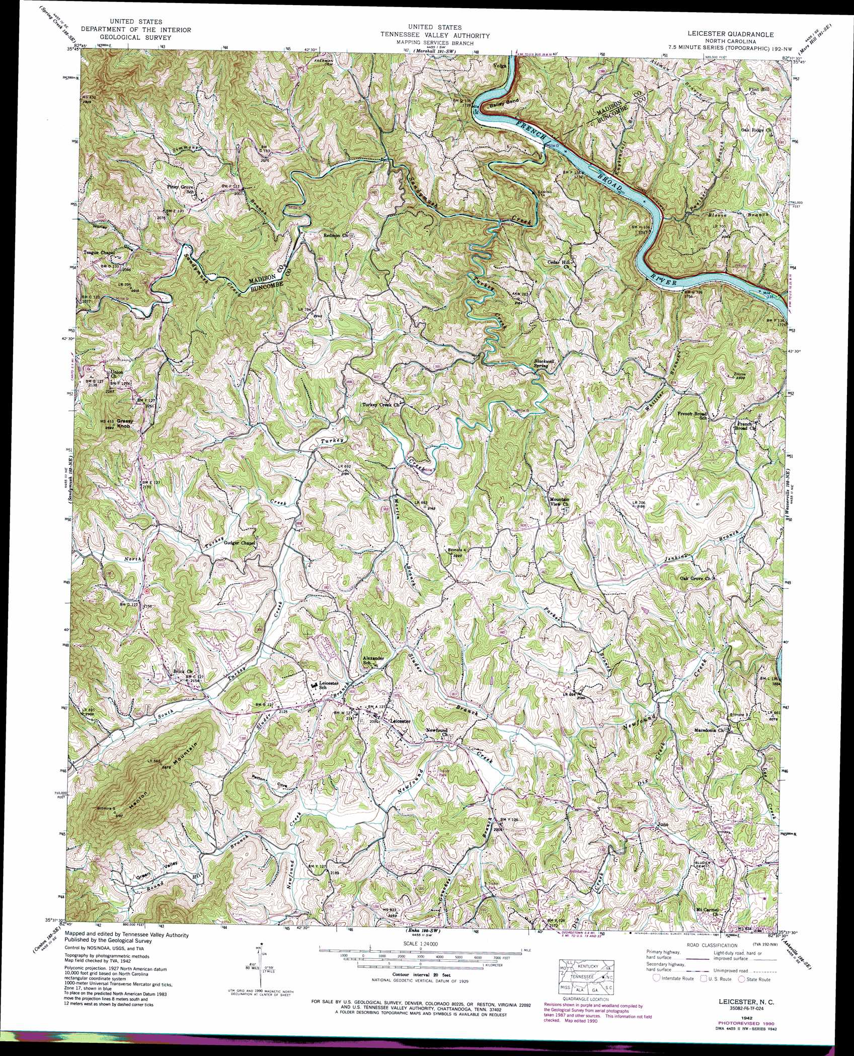
Leicester Topo Map North Carolina
To zoom in, hover over the map of Leicester
USGS Topo Quad 35082f6 - 1:24,000 scale
| Topo Map Name: | Leicester |
| USGS Topo Quad ID: | 35082f6 |
| Print Size: | ca. 21 1/4" wide x 27" high |
| Southeast Coordinates: | 35.625° N latitude / 82.625° W longitude |
| Map Center Coordinates: | 35.6875° N latitude / 82.6875° W longitude |
| U.S. State: | NC |
| Filename: | o35082f6.jpg |
| Download Map JPG Image: | Leicester topo map 1:24,000 scale |
| Map Type: | Topographic |
| Topo Series: | 7.5´ |
| Map Scale: | 1:24,000 |
| Source of Map Images: | United States Geological Survey (USGS) |
| Alternate Map Versions: |
Leicester NC 1936 Download PDF Buy paper map Leicester NC 1942, updated 1958 Download PDF Buy paper map Leicester NC 1942, updated 1966 Download PDF Buy paper map Leicester NC 1942, updated 1979 Download PDF Buy paper map Leicester NC 1942, updated 1991 Download PDF Buy paper map Leicester NC 1943 Download PDF Buy paper map Leicester NC 2010 Download PDF Buy paper map Leicester NC 2013 Download PDF Buy paper map Leicester NC 2016 Download PDF Buy paper map |
1:24,000 Topo Quads surrounding Leicester
Paint Rock |
Hot Springs |
White Rock |
Sams Gap |
Bald Creek |
Lemon Gap |
Spring Creek |
Marshall |
Mars Hill |
Barnardsville |
Fines Creek |
Sandymush |
Leicester |
Weaverville |
Craggy Pinnacle |
Clyde |
Canton |
Enka |
Asheville |
Oteen |
Waynesville |
Cruso |
Dunsmore Mountain |
Skyland |
Fruitland |
> Back to 35082e1 at 1:100,000 scale
> Back to 35082a1 at 1:250,000 scale
> Back to U.S. Topo Maps home
Leicester topo map: Gazetteer
Leicester: Bends
Bailey Bend elevation 619m 2030′Leicester: Populated Places
Juno elevation 605m 1984′Leicester elevation 636m 2086′
Leicester: Springs
Blackwell Spring elevation 578m 1896′Leicester: Streams
Blevin Branch elevation 550m 1804′Dix Creek elevation 644m 2112′
Flat Creek elevation 535m 1755′
Gouches Branch elevation 599m 1965′
Kuykendall Branch elevation 528m 1732′
Martin Branch elevation 602m 1975′
Newfound Creek elevation 567m 1860′
North Turkey Creek elevation 622m 2040′
Panther Branch elevation 529m 1735′
Parker Branch elevation 588m 1929′
Round Hill Branch elevation 622m 2040′
Sandymush Creek elevation 523m 1715′
Simmons Branch elevation 576m 1889′
Sluder Branch elevation 597m 1958′
South Turkey Creek elevation 618m 2027′
Turkey Creek elevation 540m 1771′
Whittier Branch elevation 531m 1742′
Leicester: Summits
Grassy Knob elevation 820m 2690′Hanlon Mountain elevation 972m 3188′
Leicester: Valleys
Green Valley elevation 622m 2040′Patton Cove elevation 614m 2014′
Worley Cove elevation 595m 1952′
Leicester digital topo map on disk
Buy this Leicester topo map showing relief, roads, GPS coordinates and other geographical features, as a high-resolution digital map file on DVD:
South Carolina, Western North Carolina & Northeastern Georgia
Buy digital topo maps: South Carolina, Western North Carolina & Northeastern Georgia