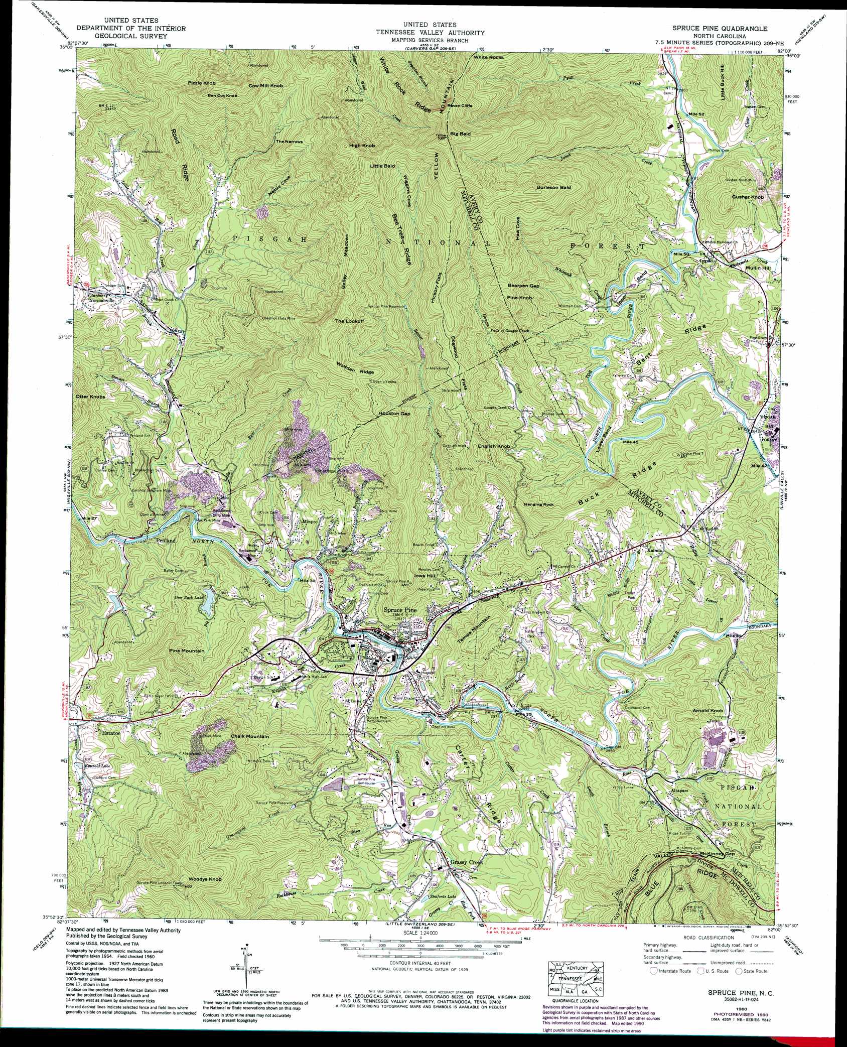
Spruce Pine Topo Map North Carolina
To zoom in, hover over the map of Spruce Pine
USGS Topo Quad 35082h1 - 1:24,000 scale
| Topo Map Name: | Spruce Pine |
| USGS Topo Quad ID: | 35082h1 |
| Print Size: | ca. 21 1/4" wide x 27" high |
| Southeast Coordinates: | 35.875° N latitude / 82° W longitude |
| Map Center Coordinates: | 35.9375° N latitude / 82.0625° W longitude |
| U.S. State: | NC |
| Filename: | o35082h1.jpg |
| Download Map JPG Image: | Spruce Pine topo map 1:24,000 scale |
| Map Type: | Topographic |
| Topo Series: | 7.5´ |
| Map Scale: | 1:24,000 |
| Source of Map Images: | United States Geological Survey (USGS) |
| Alternate Map Versions: |
Spruce Pine NC 1934 Download PDF Buy paper map Spruce Pine NC 1960, updated 1962 Download PDF Buy paper map Spruce Pine NC 1960, updated 1969 Download PDF Buy paper map Spruce Pine NC 1960, updated 1979 Download PDF Buy paper map Spruce Pine NC 1960, updated 1990 Download PDF Buy paper map Spruce Pine NC 1960, updated 1990 Download PDF Buy paper map Spruce Pine NC 1994, updated 1998 Download PDF Buy paper map Spruce Pine NC 2011 Download PDF Buy paper map Spruce Pine NC 2013 Download PDF Buy paper map Spruce Pine NC 2016 Download PDF Buy paper map |
| FStopo: | US Forest Service topo Spruce Pine is available: Download FStopo PDF Download FStopo TIF |
1:24,000 Topo Quads surrounding Spruce Pine
Unicoi |
Iron Mountain Gap |
White Rocks Mountain |
Elk Park |
Valle Crucis |
Huntdale |
Bakersville |
Carvers Gap |
Newland |
Grandfather Mountain |
Burnsville |
Micaville |
Spruce Pine |
Linville Falls |
Chestnut Mountain |
Mount Mitchell |
Celo |
Little Switzerland |
Ashford |
Oak Hill |
Montreat |
Old Fort |
Marion West |
Marion East |
Glen Alpine |
> Back to 35082e1 at 1:100,000 scale
> Back to 35082a1 at 1:250,000 scale
> Back to U.S. Topo Maps home
Spruce Pine topo map: Gazetteer
Spruce Pine: Bays
Haw Cove elevation 1242m 4074′Spruce Pine: Bends
Lower Bend elevation 872m 2860′Upper Bend elevation 876m 2874′
Spruce Pine: Cliffs
Raven Cliffs elevation 1479m 4852′Spruce Pine: Dams
Beaver Creek Spruce Pine Supply Dam elevation 1021m 3349′Deer Park Lake Dam elevation 810m 2657′
Gusher Knob Dam elevation 922m 3024′
Saylors Lake Dam elevation 877m 2877′
Swiss Pine Lake Dam elevation 809m 2654′
Spruce Pine: Falls
Falls of Gouges Creek elevation 964m 3162′Spruce Pine: Flats
Bailey Meadows elevation 1287m 4222′Dogwood Flats elevation 1104m 3622′
Hickory Flats elevation 1214m 3982′
Spruce Pine: Gaps
Bearpen Gap elevation 1129m 3704′Houston Gap elevation 1118m 3667′
McKinney Gap elevation 842m 2762′
Spruce Pine: Mines
Carolina Southern Mine elevation 822m 2696′Chalk Mine elevation 963m 3159′
Chestnut Flats Mine elevation 1052m 3451′
Deer Park Mine elevation 771m 2529′
Gudger Mine elevation 809m 2654′
Gusher Knob Mine elevation 895m 2936′
International Mine elevation 901m 2956′
Spruce Pine: Parks
Brad Ragan Memorial Recreation Park elevation 798m 2618′Spruce Pine: Populated Places
Altapass elevation 836m 2742′Estatoe elevation 803m 2634′
Grassy Creek elevation 800m 2624′
Ingalls elevation 843m 2765′
Kalmia elevation 861m 2824′
Minpro elevation 785m 2575′
Normanville elevation 842m 2762′
Penland elevation 750m 2460′
Spruce Pine elevation 780m 2559′
Spruce Pine: Reservoirs
Deer Park Lake elevation 810m 2657′Emerald Lake elevation 809m 2654′
Gusher Knob Lake elevation 922m 3024′
Noname elevation 1021m 3349′
Saylors Lake elevation 877m 2877′
Shafords Lake elevation 813m 2667′
Spruce Pine Reservoir elevation 1015m 3330′
Spruce Pine Reservoir elevation 854m 2801′
Swiss Pine Lake elevation 809m 2654′
Spruce Pine: Ridges
Bee Tree Ridge elevation 1260m 4133′Bent Ridge elevation 986m 3234′
Buck Ridge elevation 990m 3248′
Carter Ridge elevation 853m 2798′
Road Ridge elevation 1130m 3707′
The Narrows elevation 1021m 3349′
White Rock Ridge elevation 1184m 3884′
Wolfden Ridge elevation 1227m 4025′
Spruce Pine: Streams
Banjo Branch elevation 774m 2539′Bear Creek elevation 746m 2447′
Beaver Creek elevation 763m 2503′
Big Branch elevation 755m 2477′
Biggerstaff Branch elevation 788m 2585′
Bill Davenport Branch elevation 785m 2575′
Cathis Creek elevation 769m 2522′
Clear Creek elevation 846m 2775′
Cranberry Branch elevation 800m 2624′
East Fork Grassy Creek elevation 799m 2621′
English Creek elevation 760m 2493′
Gouges Creek elevation 814m 2670′
Grassy Creek elevation 765m 2509′
Graveyard Creek elevation 782m 2565′
Hanging Rock Branch elevation 794m 2604′
Holley Branch elevation 786m 2578′
Jakes Creek elevation 782m 2565′
Jones Creek elevation 842m 2762′
Little Bear Creek elevation 806m 2644′
Little Bear Creek elevation 757m 2483′
Little Laurel Branch elevation 785m 2575′
Little Rose Creek elevation 786m 2578′
Middle Ridge Branch elevation 805m 2641′
Pine Branch elevation 769m 2522′
Pyatt Creek elevation 849m 2785′
Rockhouse Creek elevation 952m 3123′
Roses Creek elevation 778m 2552′
Silver Run elevation 786m 2578′
Smith Branch elevation 779m 2555′
Stewart Branch elevation 783m 2568′
Sullins Branch elevation 761m 2496′
Threemile Creek elevation 837m 2746′
Whiteoak Creek elevation 825m 2706′
Spruce Pine: Summits
Arnold Knob elevation 935m 3067′Ben Cox Knob elevation 1288m 4225′
Big Bald elevation 1609m 5278′
Burleson Bald elevation 1415m 4642′
Chalk Mountain elevation 1086m 3562′
Cow Mill Knob elevation 1327m 4353′
English Knob elevation 1110m 3641′
Gusher Knob elevation 1015m 3330′
Hanging Rock elevation 1005m 3297′
High Knob elevation 1456m 4776′
Iowa Hill elevation 998m 3274′
Little Bald elevation 1511m 4957′
Mullin Hill elevation 902m 2959′
Pine Knob elevation 1181m 3874′
Pine Mountain elevation 1015m 3330′
Pizzle Knob elevation 1304m 4278′
Tempa Mountain elevation 948m 3110′
The Lookoff elevation 1335m 4379′
White Rocks elevation 1423m 4668′
Woodys Knob elevation 1272m 4173′
Yellow Mountain elevation 1609m 5278′
Spruce Pine: Tunnels
Rough Ridge Tunnel elevation 860m 2821′Vance Tunnel elevation 827m 2713′
Spruce Pine: Valleys
Nettle Cove elevation 854m 2801′Wiggins Cove elevation 1179m 3868′
Spruce Pine digital topo map on disk
Buy this Spruce Pine topo map showing relief, roads, GPS coordinates and other geographical features, as a high-resolution digital map file on DVD:
South Carolina, Western North Carolina & Northeastern Georgia
Buy digital topo maps: South Carolina, Western North Carolina & Northeastern Georgia